
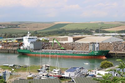
CELINA
General Cargo
Current Trip
| Time Travelled | 1 day |
|---|---|
| Remaining Time | --- |
| Distance Travelled | 248.06 nm |
| Remaining Distance | --- |
| AVG Speed | 9.5 Noeuds |
| MAX Speed | 10.1 Noeuds |
| AVG Wind | 10.6 knots |
| MAX Wind | 15 knots |
| MIN Temp | 7.7°C / 45.86°F |
| MAX Temp | 18.1°C / 64.58°F |
| Tirant d eau | 7.3 m |
| Position reçue | 1 m depuis |
Current Position
| Longitude | 22.31077° |
|---|---|
| Latitude | 59.41989° |
| Etat | Under way using engine |
| Vitesse | 9.6 Noeuds |
| Parcours | 233.6° |
| Zone | Baltic Sea |
| Station | T-AIS |
| Position reçue | 1 m depuis |
Info
Information
The current position of CELINA is in Baltic Sea with coordinates 59.41989° / 22.31077° as reported on 2024-05-16 11:13 by AIS to our vessel tracker app. The vessel's current speed is 9.6 Noeuds and is heading at the port of BILBAO. The estimated time of arrival as calculated by MyShipTracking vessel tracking app is 2024-05-23 15:00 LT
The vessel CELINA (IMO: 9019200, MMSI: 304099000) is a General Cargo that was built in 2001 ( 23 Age ). It's sailing under the flag of [AG] Antigua Barbuda.
In this page you can find informations about the vessels current position, last detected port calls, and current voyage information. If the vessels is not in coverage by AIS you will find the latest position.
The current position of CELINA is detected by our AIS receivers and we are not responsible for the reliability of the data. The last position was recorded while the vessel was in Coverage by the Ais receivers of our vessel tracking app.
The current draught of CELINA as reported by AIS is 7.3 meters
Weather
| Temperature | 8.7°C / 47.66°F |
|---|---|
| Wind Speed | 7 knots |
| Direction | 256° WSW |
| Pressure | 1025.9 hPa |
| Humidity | 78.8 % |
| Cloud Coverage | 11 % |
Featured Company
Last Port Calls
| Port | Arrival | Departure | Time In Port |
|---|---|---|---|
| 2024-05-12 16:51 | 2024-05-15 09:07 | 2 d | |
| 2024-04-28 20:52 | 2024-04-30 04:11 | 1 d | |
| 2024-04-21 15:41 | 2024-04-24 08:04 | 2 d | |
| 2024-04-17 03:50 | 2024-04-18 02:18 | 22 h | |
| 2024-04-12 09:18 | 2024-04-14 15:10 | 2 d | |
| 2024-04-12 08:25 | 2024-04-12 08:30 | 4 m | |
| 2024-04-09 10:34 | 2024-04-10 01:46 | 15 h | |
| 2024-04-07 04:02 | 2024-04-07 04:13 | 11 m | |
| 2024-04-06 02:16 | 2024-04-07 03:17 | 1 d | |
| 2024-04-02 20:20 | 2024-04-03 14:26 | 18 h |
Last Trips
| Origin | Departure | Destination | Arrival | Distance | |
|---|---|---|---|---|---|
| 2024-04-30 06:11 | 2024-05-12 19:51 | 1820.49 nm | |||
| 2024-04-24 11:04 | 2024-04-28 22:52 | 579.73 nm | |||
| 2024-04-18 04:18 | 2024-04-21 18:41 | 581.88 nm | |||
| 2024-04-14 18:10 | 2024-04-17 05:50 | 550.34 nm | |||
| 2024-04-12 11:30 | 2024-04-12 12:18 | 5.64 nm | |||
| 2024-04-10 03:46 | 2024-04-12 11:25 | 539.01 nm | |||
| 2024-04-07 07:13 | 2024-04-09 12:34 | 540.06 nm | |||
| 2024-04-07 06:17 | 2024-04-07 07:02 | 7.16 nm | |||
| 2024-04-03 16:26 | 2024-04-06 05:16 | 546.92 nm | |||
| 2024-03-31 14:57 | 2024-04-02 22:20 | 546.87 nm |
Events
| Heure | Evenement | Détails | Position/ Destination | Info |
|---|---|---|---|---|
| 2024-05-16 08:28 | Detecté en mer | Finnish part of the Baltic Sea |
59.59101 / 23.10041
Baltic Sea
ES BIO
|
Vitesse: 9.7 kn Parcours: 252.5° |
| 2024-05-16 03:01 | Detecté en mer | Finnish part of the Gulf of Finland |
59.83084 / 24.76976
Gulf of Finland
ES BIO
|
Vitesse: 9.8 kn Parcours: 257.7° |
| 2024-05-16 01:25 | Detecté en mer | Estonian part of the Gulf of Finland |
59.88280 / 25.26488
Gulf of Finland
ES BIO
|
Vitesse: 9.6 kn Parcours: 257.4° |
| 2024-05-15 22:54 | Etat Changé | Under way using engine Default |
59.96614 / 26.04247
ES BIO
|
Vitesse: 9.6 kn Parcours: 257° |
| 2024-05-15 22:45 | Etat Changé | Default Under way using engine |
59.97144 / 26.09166
ES BIO
|
Vitesse: 9.7 kn Parcours: 257.3° |
| 2024-05-15 22:23 | Detecté en mer | Finnish part of the Gulf of Finland |
59.98358 / 26.20381
Gulf of Finland
ES BIO
|
Vitesse: 9.7 kn Parcours: 256.3° |
| 2024-05-15 22:20 | Changement de zone | Estonian part of the Gulf of Finland Finnish part of the Gulf of Finland |
59.98538 / 26.21860
Gulf of Finland
ES BIO
|
Vitesse: 9.6 kn Parcours: 256.3° |
| 2024-05-15 21:56 | Detecté en mer | Finnish part of the Gulf of Finland |
59.99927 / 26.34432
Gulf of Finland
ES BIO
|
Vitesse: 9.7 kn Parcours: 258° |
| 2024-05-15 11:42 | Etat Changé | Under way using engine Default |
60.02842 / 29.39957
ES BIO
|
Vitesse: 9.7 kn Parcours: 273° |
| 2024-05-15 11:29 | Dans la zone couverte |
60.02889 / 29.38773
Gulf of Finland
ES BIO
|
Vitesse: 9.8 kn Parcours: 273.7° |