
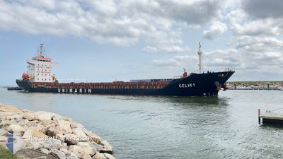
CELIK 1
General Cargo
Current Trip
| Time Travelled | 4 days |
|---|---|
| Remaining Time | --- |
| Distance Travelled | 276.61 nm |
| Remaining Distance | --- |
| AVG Speed | 9.2 Noeuds |
| MAX Speed | 11.5 Noeuds |
| AVG Wind | 19.6 knots |
| MAX Wind | 30 knots |
| MIN Temp | 3.2°C / 37.76°F |
| MAX Temp | 7.3°C / 45.14°F |
| Tirant d eau | 4.1 m |
| Position reçue | 4 d depuis |
Current Position
| Longitude | --- |
|---|---|
| Latitude | --- |
| Etat | Under way using engine |
| Vitesse | 9.8 Noeuds |
| Parcours | 142° |
| Zone | Black Sea |
| Station | T-AIS |
| Position reçue | 4 d depuis |
Info
Information
The current position of CELIK 1 is in Black Sea with coordinates 44.01430° / 28.76776° as reported on 2025-02-15 11:09 by AIS to our vessel tracker app. The vessel's current speed is 9.8 Noeuds
The vessel CELIK 1 (IMO: 9430791, MMSI: 636023014) is a General Cargo that was built in 2007 ( 18 Age ). It's sailing under the flag of [LR] Liberia.
In this page you can find informations about the vessels current position, last detected port calls, and current voyage information. If the vessels is not in coverage by AIS you will find the latest position.
The current position of CELIK 1 is detected by our AIS receivers and we are not responsible for the reliability of the data. The last position was recorded while the vessel was in Coverage by the Ais receivers of our vessel tracking app.
The current draught of CELIK 1 as reported by AIS is 4.1 meters
Weather
| Temperature | 2.7°C / 36.86°F |
|---|---|
| Wind Speed | 12 knots |
| Direction | 21° NNE |
| Pressure | 1029.5 hPa |
| Humidity | 61.1 % |
| Cloud Coverage | 100 % |
Featured Company
Last Port Calls
| Port | Arrival | Departure | Time In Port |
|---|---|---|---|
| 2025-02-12 08:26 | 2025-02-15 10:32 | 3 d | |
| 2025-01-30 14:16 | 2025-02-04 13:19 | 4 d | |
| 2025-01-23 12:20 | 2025-01-27 21:03 | 4 d | |
| 2025-01-16 05:58 | 2025-01-19 07:43 | 3 d | |
| 2025-01-08 07:52 | 2025-01-12 07:31 | 3 d | |
| 2024-12-19 07:20 | 2024-12-31 08:43 | 12 d | |
| 2024-12-06 21:23 | 2024-12-10 00:42 | 3 d | |
| 2024-12-02 17:52 |
Last Trips
| Origin | Departure | Destination | Arrival | Distance | |
|---|---|---|---|---|---|
| 2025-02-04 14:19 | 2025-02-12 10:26 | 1468.62 nm | |||
| 2025-01-27 22:03 | 2025-01-30 15:16 | 412.34 nm | |||
| 2025-01-19 08:43 | 2025-01-23 13:20 | 706.32 nm | |||
| 2025-01-12 08:31 | 2025-01-16 06:58 | 283.63 nm | |||
| 2024-12-31 09:43 | 2025-01-08 08:52 | 1447.48 nm | |||
| 2024-12-10 00:42 | 2024-12-19 08:20 | 2060.47 nm | |||
| 2024-12-02 17:52 | 2024-12-06 21:23 | 948.82 nm |
Events
| Heure | Evenement | Détails | Position/ Destination | Info |
|---|---|---|---|---|
| 2025-02-17 15:35 | Arret | 5.58 nm, South West of BARTIN |
41.64154 / 32.12425
TR BTN
|
Vitesse: 0.3 kn Parcours: 42° |
| 2025-02-17 14:25 | Démarrage | 1.63 nm, West of BARTIN |
41.68315 / 32.19783
TR BTN
|
Vitesse: 5.2 kn Parcours: 289° |
| 2025-02-16 14:41 | Arret | 1.34 nm, West of BARTIN |
41.68344 / 32.20434
TR BTN
|
Vitesse: 0.3 kn Parcours: 17° |
| 2025-02-15 11:13 | Etat Changé | Default Under way using engine |
44.00357 / 28.77886
TR BTN
|
Vitesse: 9.8 kn Parcours: 142° |
| 2025-02-15 11:09 | Hors de la zone couverte |
44.01430 / 28.76776
Black Sea
TR BTN
|
Vitesse: 9.8 kn Parcours: 142° |
|
| 2025-02-15 11:04 | Etat Changé | Under way using engine Default |
44.02472 / 28.75665
TR BTN
|
Vitesse: 9.6 kn Parcours: 142° |
| 2025-02-15 11:01 | Etat Changé | Default Moored |
44.02998 / 28.75096
TR BTN
|
Vitesse: 9.6 kn Parcours: 144.3° |
| 2025-02-15 10:32 | PORT DE DEPART |
|
44.09891 / 28.70424
TR BTN
|
Vitesse: 9.7 kn Parcours: 148° |
| 2025-02-15 10:20 | Tirant d'eau modifié | 4.1 6 |
44.10360 / 28.67752
[RO] CONSTANTA
|
Vitesse: 6.2 kn Parcours: 95° |
| 2025-02-15 10:20 | Changement de destination | TR BTN RO CND |
44.10360 / 28.67752
[RO] CONSTANTA
|
Vitesse: 6.2 kn Parcours: 95° |