
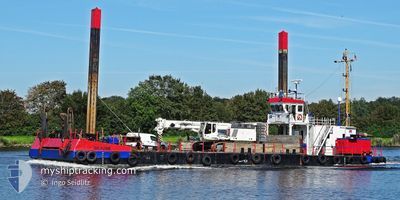
BRAUNE
Dredging or underwater ops
Current Trip
ROBBENPLATE
| Time Travelled | 1 day |
|---|---|
| Remaining Time | --- |
| Distance Travelled | 15.57 nm |
| Remaining Distance | --- |
| AVG Speed | 4.4 Noeuds |
| MAX Speed | 6.7 Noeuds |
| AVG Wind | 14.5 knots |
| MAX Wind | 16.4 knots |
| MIN Temp | 11°C / 51.8°F |
| MAX Temp | 14.3°C / 57.74°F |
| Tirant d eau | 1.5 m |
| Position reçue | Maintenant |
Current Position
| Longitude | 8.32784° |
|---|---|
| Latitude | 53.71863° |
| Etat | Restricted manoeuverability |
| Vitesse | |
| Parcours | 127° |
| Zone | North Sea |
| Station | T-AIS |
| Position reçue | Maintenant |
Info
Information
The current position of BRAUNE is in North Sea with coordinates 53.71863° / 8.32784° as reported on 2024-09-12 08:13 by AIS to our vessel tracker app. The vessel's current speed is 0 Noeuds
The vessel BRAUNE (MMSI: 211236860) is a Dredging or underwater ops It's sailing under the flag of [DE] Germany.
In this page you can find informations about the vessels current position, last detected port calls, and current voyage information. If the vessels is not in coverage by AIS you will find the latest position.
The current position of BRAUNE is detected by our AIS receivers and we are not responsible for the reliability of the data. The last position was recorded while the vessel was in Coverage by the Ais receivers of our vessel tracking app.
The current draught of BRAUNE as reported by AIS is 1.5 meters
Weather
| Temperature | 11.5°C / 52.7°F |
|---|---|
| Wind Speed | 15 knots |
| Direction | 230° SW |
| Pressure | 1009.4 hPa |
| Humidity | 80.5 % |
| Cloud Coverage | 71 % |
Featured Company
Last Port Calls
| Port | Arrival | Departure | Time In Port |
|---|---|---|---|
| 2024-09-10 18:08 | 2024-09-10 22:45 | 4 h | |
| 2024-09-05 12:12 | 2024-09-06 16:16 | 1 d | |
| 2024-08-28 04:00 | 2024-09-02 05:02 | 5 d | |
| 2024-08-24 16:12 | 2024-08-27 05:53 | 2 d | |
| 2024-08-22 16:25 | 2024-08-24 04:24 | 1 d | |
| 2024-08-19 20:36 | 2024-08-20 12:16 | 15 h | |
| 2024-08-14 16:21 | 2024-08-19 12:46 | 4 d | |
| 2024-08-06 12:19 | 2024-08-12 06:15 | 5 d | |
| 2024-08-06 07:43 | |||
| 2024-08-03 21:12 | 2024-08-05 02:15 | 1 d |
Most Visited Ports (Last year)
| Port | Arrivals | |
|---|---|---|
| 51 | ||
| 19 | ||
| 5 | ||
| 5 | ||
| 2 | ||
| 1 |
Last Trips
| Origin | Departure | Destination | Arrival | Distance | |
|---|---|---|---|---|---|
| 2024-09-06 18:16 | 2024-09-10 20:08 | 62.54 nm | |||
| 2024-09-02 07:02 | 2024-09-05 14:12 | 41.15 nm | |||
| 2024-08-27 07:53 | 2024-08-28 06:00 | 11.94 nm | |||
| 2024-08-24 06:24 | 2024-08-24 18:12 | 74.45 nm | |||
| 2024-08-20 14:16 | 2024-08-22 18:25 | 17.27 nm | |||
| 2024-08-19 14:46 | 2024-08-19 22:36 | 62.52 nm | |||
| 2024-08-12 08:15 | 2024-08-14 18:21 | 245.10 nm | |||
| 2024-08-06 09:43 | 2024-08-06 14:19 | 34.81 nm | |||
| 2024-08-03 14:19 | 2024-08-03 23:12 | 1.23 nm | |||
| 2024-07-30 07:51 | 2024-08-01 11:43 | 224.52 nm |
Events
| Heure | Evenement | Détails | Position/ Destination | Info |
|---|---|---|---|---|
| 2024-09-12 05:17 | Arret | 10.64 nm, North East of HOOKSIEL |
53.71864 / 8.32832
ROBBENPLATE
|
Vitesse: 0.2 kn Parcours: 206° |
| 2024-09-12 05:10 | Démarrage | 10.56 nm, North East of HOOKSIEL |
53.72355 / 8.32107
ROBBENPLATE
|
Vitesse: 3.2 kn Parcours: 138° |
| 2024-09-11 17:28 | Arret | 10.57 nm, North East of HOOKSIEL |
53.72541 / 8.31942
ROBBENPLATE
|
Vitesse: 0.1 kn Parcours: 176° |
| 2024-09-11 17:20 | Démarrage | 10.49 nm, North East of HOOKSIEL |
53.73002 / 8.31206
ROBBENPLATE
|
Vitesse: 3.1 kn Parcours: 137° |
| 2024-09-11 14:57 | Arret | 10.45 nm, North East of HOOKSIEL |
53.73145 / 8.30927
ROBBENPLATE
|
Vitesse: 0.2 kn Parcours: 135° |
| 2024-09-11 14:51 | Démarrage | 10.39 nm, North East of HOOKSIEL |
53.73407 / 8.30436
ROBBENPLATE
|
Vitesse: 3.6 kn Parcours: 143° |
| 2024-09-11 14:48 | Arret | 10.37 nm, North East of HOOKSIEL |
53.73538 / 8.30199
ROBBENPLATE
|
Vitesse: 0.2 kn Parcours: 131° |
| 2024-09-11 14:47 | Démarrage | 10.36 nm, North East of HOOKSIEL |
53.73591 / 8.30088
ROBBENPLATE
|
Vitesse: 3.5 kn Parcours: 134° |
| 2024-09-11 13:07 | Arret | 10.32 nm, North East of HOOKSIEL |
53.73706 / 8.29838
ROBBENPLATE
|
Vitesse: Parcours: 141° |
| 2024-09-11 13:00 | Démarrage | 10.2 nm, East of WANGERSIEL |
53.74186 / 8.29058
ROBBENPLATE
|
Vitesse: 4.3 kn Parcours: 142° |