
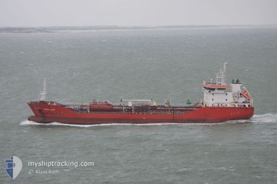
BOMAR MARS
Oil/Chemical Tanker
Current Trip
| Time Travelled | 3 days |
|---|---|
| Remaining Time | 1 day |
| Distance Travelled | 845.33 nm |
| Remaining Distance | 306.43 nm |
| AVG Speed | 10 Noeuds |
| MAX Speed | 12.6 Noeuds |
| AVG Wind | 9.2 knots |
| MAX Wind | 24.9 knots |
| MIN Temp | 9.3°C / 48.74°F |
| MAX Temp | 16.6°C / 61.88°F |
| Tirant d eau | 6.4 m |
| Position reçue | 9 h, 47 m depuis |
Current Position
| Longitude | --- |
|---|---|
| Latitude | --- |
| Etat | Under way using engine |
| Vitesse | 10.3 Noeuds |
| Parcours | 282.3° |
| Zone | North Atlantic Ocean |
| Station | T-AIS |
| Position reçue | 9 h, 47 m depuis |
Info
Information
The current position of BOMAR MARS is in North Atlantic Ocean with coordinates 35.96683° / -6.27500° as reported on 2025-02-17 00:30 by AIS to our vessel tracker app. The vessel's current speed is 10.3 Noeuds and is heading at the port of AVEIRO. The estimated time of arrival as calculated by MyShipTracking vessel tracking app is 2025-02-18 14:49 LT
The vessel BOMAR MARS (IMO: 9377030, MMSI: 256784000) is a Oil/Chemical Tanker that was built in 2007 ( 18 Age ). It's sailing under the flag of [MT] Malta.
In this page you can find informations about the vessels current position, last detected port calls, and current voyage information. If the vessels is not in coverage by AIS you will find the latest position.
The current position of BOMAR MARS is detected by our AIS receivers and we are not responsible for the reliability of the data. The last position was recorded while the vessel was in Coverage by the Ais receivers of our vessel tracking app.
The current draught of BOMAR MARS as reported by AIS is 6.4 meters
Weather
| Temperature | 15.6°C / 60.08°F |
|---|---|
| Wind Speed | 7 knots |
| Direction | 122° ESE |
| Pressure | 1016.4 hPa |
| Humidity | 73 % |
| Cloud Coverage | 100 % |
Featured Company
Last Port Calls
| Port | Arrival | Departure | Time In Port |
|---|---|---|---|
| 2025-02-12 23:35 | 2025-02-14 02:40 | 1 d | |
| 2025-02-11 18:15 | 2025-02-12 23:15 | 1 d | |
| 2025-02-06 15:53 | 2025-02-08 16:33 | 2 d | |
| 2025-02-03 05:46 | 2025-02-04 03:29 | 21 h | |
| 2025-01-21 15:14 | 2025-01-23 07:44 | 1 d | |
| 2025-01-11 02:07 | 2025-01-12 03:54 | 1 d | |
| 2025-01-04 18:48 | 2025-01-04 23:43 | 4 h | |
| 2025-01-03 09:36 | 2025-01-04 04:08 | 18 h | |
| 2024-12-29 21:15 | 2024-12-30 19:50 | 22 h | |
| 2024-12-27 12:06 | 2024-12-28 08:00 | 19 h |
Most Visited Ports (Last year)
| Port | Arrivals | |
|---|---|---|
| 8 | ||
| 4 | ||
| 4 | ||
| 4 | ||
| 3 | ||
| 3 |
Last Trips
| Origin | Departure | Destination | Arrival | Distance | |
|---|---|---|---|---|---|
| 2025-02-13 00:15 | 2025-02-13 00:35 | 3.23 nm | |||
| 2025-02-08 17:33 | 2025-02-11 19:15 | 776.88 nm | |||
| 2025-02-04 06:29 | 2025-02-06 16:53 | 635.12 nm | |||
| 2025-01-23 09:44 | 2025-02-03 08:46 | 240.91 nm | |||
| 2025-01-12 04:54 | 2025-01-21 17:14 | 1668.96 nm | |||
| 2025-01-05 00:43 | 2025-01-11 03:07 | 369.15 nm | |||
| 2025-01-04 05:08 | 2025-01-04 19:48 | 33.51 nm | |||
| 2024-12-30 20:50 | 2025-01-03 10:36 | 897.29 nm | |||
| 2024-12-28 09:00 | 2024-12-29 22:15 | 427.48 nm | |||
| 2024-12-23 09:06 | 2024-12-27 13:06 | 978.35 nm |
Events
| Heure | Evenement | Détails | Position/ Destination | Info |
|---|---|---|---|---|
| 2025-02-17 00:35 | Etat Changé | Default Under way using engine |
35.97033 / -6.29350
PTAVE
|
Vitesse: 10.3 kn Parcours: 282.3° |
| 2025-02-17 00:30 | Hors de la zone couverte |
35.96683 / -6.27500
North Atlantic Ocean
PTAVE
|
Vitesse: 10.3 kn Parcours: 282.3° |
|
| 2025-02-16 23:41 | Changement de zone | Spanish part of the North Atlantic Ocean Moroccan part of the North Atlantic Ocean |
35.95550 / -6.10733
North Atlantic Ocean
PTAVE
|
Vitesse: 9.8 kn Parcours: 270° |
| 2025-02-16 23:39 | Etat Changé | Under way using engine Default |
35.95517 / -6.10100
PTAVE
|
Vitesse: 10.2 kn Parcours: 272° |
| 2025-02-16 23:22 | Etat Changé | Default Under way using engine |
35.95533 / -6.04317
PTAVE
|
Vitesse: 10 kn Parcours: 268.3° |
| 2025-02-16 23:15 | Etat Changé | Under way using engine Default |
35.95517 / -6.01800
PTAVE
|
Vitesse: 10.2 kn Parcours: 273° |
| 2025-02-16 23:08 | Etat Changé | Default Under way using engine |
35.95500 / -5.99633
PTAVE
|
Vitesse: 10.1 kn Parcours: 269.9° |
| 2025-02-16 23:05 | Etat Changé | Under way using engine Default |
35.95483 / -5.98550
PTAVE
|
Vitesse: 10.3 kn Parcours: 271° |
| 2025-02-16 23:05 | Detecté en mer | Moroccan part of the North Atlantic Ocean |
35.95483 / -5.98550
North Atlantic Ocean
PTAVE
|
Vitesse: 10.1 kn Parcours: 269.9° |
| 2025-02-16 22:32 | Etat Changé | Default Under way using engine |
35.95400 / -5.87183
PTAVE
|
Vitesse: 10.1 kn Parcours: 271.1° |