
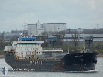
BLAIR MCKEIL
General Cargo
Current Trip
| Time Travelled | 23 h, 56 mins |
|---|---|
| Remaining Time | --- |
| Distance Travelled | 279.17 nm |
| Remaining Distance | 312.88 nm |
| AVG Speed | 13 Noeuds |
| MAX Speed | 17.4 Noeuds |
| AVG Wind | 5.1 knots |
| MAX Wind | 11.9 knots |
| MIN Temp | -0.9°C / 30.38°F |
| MAX Temp | 12.2°C / 53.96°F |
| Tirant d eau | 5.5 m |
| Position reçue | 8 h, 55 m depuis |
Current Position
| Longitude | -70.22601° |
|---|---|
| Latitude | 47.46910° |
| Etat | Under way using engine |
| Vitesse | 12.7 Noeuds |
| Parcours | 55.9° |
| Zone | Gulf of St-Lawrence |
| Station | T-AIS |
| Position reçue | 8 h, 55 m depuis |
Info
Information
The current position of BLAIR MCKEIL is in Gulf of St-Lawrence with coordinates 47.46910° / -70.22601° as reported on 2024-04-27 12:29 by AIS to our vessel tracker app. The vessel's current speed is 12.7 Noeuds and is heading at the port of BELLEDUNE. The estimated time of arrival as calculated by MyShipTracking vessel tracking app is 2024-04-29 11:00 LT
The vessel BLAIR MCKEIL (IMO: 9546045, MMSI: 316040355) is a General Cargo that was built in 2010 ( 14 Age ). It's sailing under the flag of [CA] Canada.
In this page you can find informations about the vessels current position, last detected port calls, and current voyage information. If the vessels is not in coverage by AIS you will find the latest position.
The current position of BLAIR MCKEIL is detected by our AIS receivers and we are not responsible for the reliability of the data. The last position was recorded while the vessel was in Coverage by the Ais receivers of our vessel tracking app.
The current draught of BLAIR MCKEIL as reported by AIS is 5.5 meters
Weather
| Temperature | 4.3°C / 39.74°F |
|---|---|
| Wind Speed | 6 knots |
| Direction | 166° SSE |
| Pressure | 1027.6 hPa |
| Humidity | 81.4 % |
| Cloud Coverage | 98 % |
Featured Company
Last Port Calls
| Port | Arrival | Departure | Time In Port |
|---|---|---|---|
| 2024-04-25 20:36 | 2024-04-26 21:29 | 1 d | |
| 2024-04-23 12:06 | 2024-04-24 10:05 | 21 h | |
| 2024-04-23 09:17 | 2024-04-23 09:48 | 30 m | |
| 2024-04-22 07:34 | 2024-04-23 01:48 | 18 h | |
| 2024-04-21 20:25 | 2024-04-21 22:01 | 1 h | |
| 2024-04-21 12:14 | 2024-04-21 12:49 | 35 m | |
| 2024-04-19 03:58 | 2024-04-21 01:08 | 1 d | |
| 2024-04-17 09:34 | 2024-04-17 10:12 | 38 m | |
| 2024-03-26 01:54 | 2024-03-26 21:24 | 19 h | |
| 2024-03-16 11:59 | 2024-03-19 01:05 | 2 d |
Most Visited Ports (Last year)
| Port | Arrivals | |
|---|---|---|
| 30 | ||
| 16 | ||
| 10 | ||
| 8 | ||
| 7 | ||
| 5 |
Last Trips
| Origin | Departure | Destination | Arrival | Distance | |
|---|---|---|---|---|---|
| 2024-04-24 06:05 | 2024-04-25 16:36 | 318.22 nm | |||
| 2024-04-23 05:48 | 2024-04-23 08:06 | 26.08 nm | |||
| 2024-04-22 21:48 | 2024-04-23 05:17 | 21.27 nm | |||
| 2024-04-21 18:01 | 2024-04-22 03:34 | 11.38 nm | |||
| 2024-04-21 08:49 | 2024-04-21 16:25 | 19.15 nm | |||
| 2024-04-20 21:08 | 2024-04-21 08:14 | 40.49 nm | |||
| 2024-04-17 06:12 | 2024-04-18 23:58 | 317.90 nm | |||
| 2024-03-26 22:24 | 2024-04-17 05:34 | 4103.82 nm | |||
| 2024-03-19 02:05 | 2024-03-26 02:54 | 1664.44 nm | |||
| 2024-03-16 08:13 | 2024-03-16 12:59 | 30.42 nm |
Events
| Heure | Evenement | Détails | Position/ Destination | Info |
|---|---|---|---|---|
| 2024-04-27 12:32 | Etat Changé | Default Under way using engine |
47.47734 / -70.21289
BELLEDUNE
|
Vitesse: 12.7 kn Parcours: 55.9° |
| 2024-04-27 12:29 | Etat Changé | Under way using engine Default |
47.46910 / -70.22601
BELLEDUNE
|
Vitesse: 12 kn Parcours: 67° |
| 2024-04-27 12:29 | Hors de la zone couverte |
47.46910 / -70.22601
Gulf of St-Lawrence
BELLEDUNE
|
Vitesse: 12.7 kn Parcours: 55.9° |
|
| 2024-04-27 12:13 | Dans la zone couverte |
47.46910 / -70.22601
Gulf of St-Lawrence
BELLEDUNE
|
Vitesse: 12.7 kn Parcours: 55.9° |
|
| 2024-04-27 11:30 | Etat Changé | Default Under way using engine |
47.39085 / -70.45388
BELLEDUNE
|
Vitesse: 8.7 kn Parcours: 25.5° |
| 2024-04-27 11:27 | Etat Changé | Under way using engine Default |
47.38234 / -70.45980
BELLEDUNE
|
Vitesse: 8 kn Parcours: 21° |
| 2024-04-27 11:27 | Hors de la zone couverte |
47.38234 / -70.45980
Gulf of St-Lawrence
BELLEDUNE
|
Vitesse: 8.7 kn Parcours: 25.5° |
|
| 2024-04-27 11:20 | Etat Changé | Default Under way using engine |
47.36833 / -70.46667
BELLEDUNE
|
Vitesse: 7.7 kn Parcours: 24.9° |
| 2024-04-27 11:00 | Etat Changé | Under way using engine Default |
47.32773 / -70.49550
BELLEDUNE
|
Vitesse: 7.8 kn Parcours: 27° |
| 2024-04-27 10:54 | Etat Changé | Default Under way using engine |
47.31669 / -70.50365
BELLEDUNE
|
Vitesse: 8.5 kn Parcours: 23.5° |