
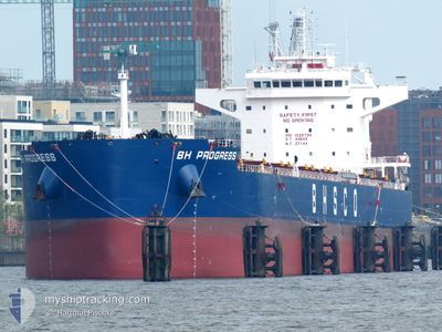
BH PROGRESS
Cargo
Current Trip
| Time Travelled | 3 days |
|---|---|
| Remaining Time | --- |
| Distance Travelled | 846.00 nm |
| Remaining Distance | --- |
| AVG Speed | 11.1 Noeuds |
| MAX Speed | 12.8 Noeuds |
| AVG Wind | 9.4 knots |
| MAX Wind | 21 knots |
| MIN Temp | 18.4°C / 65.12°F |
| MAX Temp | 26.7°C / 80.06°F |
| Tirant d eau | 14.5 m |
| Position reçue | 1 d depuis |
Current Position
| Longitude | --- |
|---|---|
| Latitude | --- |
| Etat | Under way using engine |
| Vitesse | 11.7 Noeuds |
| Parcours | 2.5° |
| Zone | Coral Sea |
| Station | T-AIS |
| Position reçue | 1 d depuis |
Info
Information
The current position of BH PROGRESS is in Coral Sea with coordinates -26.65696° / 154.29284° as reported on 2025-12-14 08:10 by AIS to our vessel tracker app. The vessel's current speed is 11.7 Noeuds and is heading at the port of NANSHA. The estimated time of arrival as calculated by MyShipTracking vessel tracking app is 2025-12-28 13:00 LT
The vessel BH PROGRESS (IMO: 102579600, MMSI: 636024708) is a Cargo It's sailing under the flag of [LR] Liberia.
In this page you can find informations about the vessels current position, last detected port calls, and current voyage information. If the vessels is not in coverage by AIS you will find the latest position.
The current position of BH PROGRESS is detected by our AIS receivers and we are not responsible for the reliability of the data. The last position was recorded while the vessel was in Coverage by the Ais receivers of our vessel tracking app.
The current draught of BH PROGRESS as reported by AIS is 14.5 meters
Weather
| Temperature | 26.4°C / 79.52°F |
|---|---|
| Wind Speed | 13 knots |
| Direction | 89° E |
| Pressure | 1011 hPa |
| Humidity | 74.6 % |
| Cloud Coverage | 8 % |
Featured Company
Last Port Calls
| Port | Arrival | Departure | Time In Port |
|---|---|---|---|
| 2025-12-12 00:25 | 2025-12-13 03:18 | 1 d | |
| 2025-11-12 15:22 | 2025-11-16 07:26 | 3 d | |
| 2025-10-05 10:32 | 2025-10-06 08:04 | 21 h |
Last Trips
| Origin | Departure | Destination | Arrival | Distance | |
|---|---|---|---|---|---|
| 2025-11-16 07:26 | 2025-12-12 00:25 | 5065.30 nm | |||
| 2025-10-06 08:04 | 2025-11-12 15:22 | 4102.99 nm | |||
| 2025-08-22 07:40 | 2025-10-05 10:32 | 3684.37 nm |
Events
| Heure | Evenement | Détails | Position/ Destination | Info |
|---|---|---|---|---|
| 2025-12-14 08:16 | Etat Changé | Default Under way using engine |
-26.63640 / 154.29352
CN XSA
|
Vitesse: 11.7 kn Parcours: 2.5° |
| 2025-12-14 08:10 | Hors de la zone couverte |
-26.65696 / 154.29284
Coral Sea
CN XSA
|
Vitesse: 11.7 kn Parcours: 2.5° |
|
| 2025-12-14 08:09 | Etat Changé | Under way using engine Default |
-26.65800 / 154.29279
CN XSA
|
Vitesse: 11.7 kn Parcours: 0° |
| 2025-12-14 07:56 | Dans la zone couverte |
-26.65696 / 154.29284
Coral Sea
CN XSA
|
Vitesse: 11.7 kn Parcours: 2.5° |
|
| 2025-12-14 07:03 | Etat Changé | Default Under way using engine |
-26.87413 / 154.29321
CN XSA
|
Vitesse: 11.7 kn Parcours: 359.1° |
| 2025-12-14 06:59 | Hors de la zone couverte |
-26.88772 / 154.29363
Coral Sea
CN XSA
|
Vitesse: 11.7 kn Parcours: 359.1° |
|
| 2025-12-14 06:49 | Etat Changé | Under way using engine Default |
-26.92125 / 154.29376
CN XSA
|
Vitesse: 11.7 kn Parcours: 0° |
| 2025-12-14 06:12 | Etat Changé | Default Under way using engine |
-27.04086 / 154.29416
CN XSA
|
Vitesse: 11.5 kn Parcours: 0.8° |
| 2025-12-14 06:02 | Etat Changé | Under way using engine Default |
-27.07296 / 154.29384
CN XSA
|
Vitesse: 11.5 kn Parcours: 359° |
| 2025-12-14 05:40 | Etat Changé | Default Under way using engine |
-27.14198 / 154.29338
CN XSA
|
Vitesse: 11.5 kn Parcours: 2.1° |