
BERGFJORD
General Cargo
Current Trip
| Time Travelled | 2 days |
|---|---|
| Remaining Time | 21 h, 47 mins |
| Distance Travelled | 591.39 nm |
| Remaining Distance | 240.26 nm |
| AVG Speed | 10.4 Noeuds |
| MAX Speed | 12.3 Noeuds |
| AVG Wind | 8.3 knots |
| MAX Wind | 30.8 knots |
| MIN Temp | -7.4°C / 18.68°F |
| MAX Temp | 1.5°C / 34.7°F |
| Tirant d eau | 5.7 m |
| Position reçue | 1 m depuis |
Current Position
| Longitude | --- |
|---|---|
| Latitude | --- |
| Etat | Under way using engine |
| Vitesse | 10.2 Noeuds |
| Parcours | 72.4° |
| Zone | Norwegian Sea |
| Station | T-AIS |
| Position reçue | 1 m depuis |
Info
Information
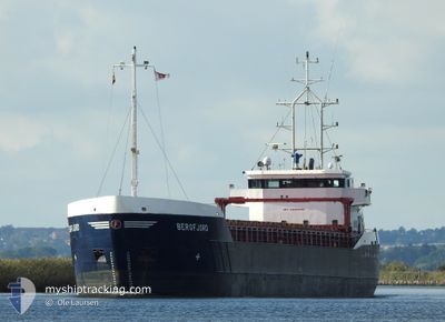
The current position of BERGFJORD is in Norwegian Sea with coordinates 63.45949° / 8.88479° as reported on 2026-01-09 17:25 by AIS to our vessel tracker app. The vessel's current speed is 10.2 Noeuds and is heading at the port of MOIRANA. The estimated time of arrival as calculated by MyShipTracking vessel tracking app is 2026-01-10 16:14 LT
The vessel BERGFJORD (IMO: 9166455, MMSI: 246483000) is a General Cargo that was built in 2000 ( 26 Age ). It's sailing under the flag of [NL] Netherlands.
In this page you can find informations about the vessels current position, last detected port calls, and current voyage information. If the vessels is not in coverage by AIS you will find the latest position.
The current position of BERGFJORD is detected by our AIS receivers and we are not responsible for the reliability of the data. The last position was recorded while the vessel was in Coverage by the Ais receivers of our vessel tracking app.
The current draught of BERGFJORD as reported by AIS is 5.7 meters
Weather
| Temperature | -6.6°C / 20.12°F |
|---|---|
| Wind Speed | 6 knots |
| Direction | 143° SE |
| Pressure | 1015.1 hPa |
| Humidity | 69.6 % |
| Cloud Coverage | 59 % |
Featured Company
Last Port Calls
| Port | Arrival | Departure | Time In Port |
|---|---|---|---|
| 2026-01-07 07:30 | 2026-01-07 09:35 | 2 h | |
| 2025-12-23 14:11 | 2025-12-23 14:30 | 19 m | |
| 2025-12-18 08:53 | 2025-12-18 09:53 | 59 m | |
| 2025-12-14 18:46 | 2025-12-16 20:22 | 2 d | |
| 2025-12-12 16:57 | 2025-12-13 08:20 | 15 h | |
| 2025-12-10 05:09 | 2025-12-10 11:49 | 6 h | |
| 2025-12-09 02:03 | 2025-12-09 11:05 | 9 h | |
| 2025-12-07 23:41 | 2025-12-08 17:25 | 17 h | |
| 2025-12-02 07:16 | 2025-12-04 02:36 | 1 d | |
| 2025-11-27 02:41 | 2025-11-28 11:44 | 1 d |
Most Visited Ports (Last year)
| Port | Arrivals | |
|---|---|---|
| 25 | ||
| 20 | ||
| 16 | ||
| 8 | ||
| 6 | ||
| 4 |
Last Trips
| Origin | Departure | Destination | Arrival | Distance | |
|---|---|---|---|---|---|
| 2025-12-23 14:30 | 2026-01-07 07:30 | 669.56 nm | |||
| 2025-12-18 09:53 | 2025-12-23 14:11 | 3.01 nm | |||
| 2025-12-16 20:22 | 2025-12-18 08:53 | 115.35 nm | |||
| 2025-12-13 08:20 | 2025-12-14 18:46 | 331.00 nm | |||
| 2025-12-10 11:49 | 2025-12-12 16:57 | 472.29 nm | |||
| 2025-12-09 11:05 | 2025-12-10 05:09 | 160.89 nm | |||
| 2025-12-08 17:25 | 2025-12-09 02:03 | 94.14 nm | |||
| 2025-12-04 02:36 | 2025-12-07 23:41 | 884.67 nm | |||
| 2025-11-28 11:44 | 2025-12-02 07:16 | 841.21 nm | |||
| 2025-11-26 10:52 | 2025-11-27 02:41 | 183.45 nm |
Events
| Heure | Evenement | Détails | Position/ Destination | Info |
|---|---|---|---|---|
| 2026-01-09 12:05 | Etat Changé | Under way using engine Default |
63.00347 / 7.03944
NOMQN
|
Vitesse: 10.8 kn Parcours: 70° |
| 2026-01-09 12:04 | Etat Changé | Default Under way using engine |
63.00236 / 7.03329
NOMQN
|
Vitesse: 10.9 kn Parcours: 68.8° |
| 2026-01-08 20:40 | Changement de zone | Norwegian part of the Norwegian Sea Norwegian part of the North Sea |
61.01067 / 4.75797
Norwegian Sea
NOMQN
|
Vitesse: 10.7 kn Parcours: 0° |
| 2026-01-08 16:08 | Démarrage | 1.38 nm, North West of HJELLESTAD |
60.26865 / 5.20132
NOMQN
|
Vitesse: 3.1 kn Parcours: 3° |
| 2026-01-08 15:04 | Arret | 1.51 nm, North West of HJELLESTAD |
60.26675 / 5.19391
NOMQN
|
Vitesse: 0.3 kn Parcours: 76° |
| 2026-01-08 07:21 | Changement d'ETA | 2026/01/10 19:00 2026/01/10 21:00 |
59.08840 / 5.34774
NOMQN
|
Vitesse: 11.1 kn Parcours: 6.7° |
| 2026-01-07 22:44 | Changement de zone | Norwegian part of the North Sea Norwegian part of the Skaggerak |
57.92619 / 7.11512
North Sea
NOMQN
|
Vitesse: 10.9 kn Parcours: 287.6° |
| 2026-01-07 16:23 | Changement de zone | Norwegian part of the Skaggerak Danish part of the Skaggerak |
57.87319 / 9.18372
Skaggerak
NOMQN
|
Vitesse: 9.7 kn Parcours: 270.6° |
| 2026-01-07 10:58 | Changement de zone | Danish part of the Skaggerak Danish part of the Kattegat |
57.77669 / 10.79445
Skaggerak
NOMQN
|
Vitesse: 10.9 kn Parcours: 2.9° |
| 2026-01-07 08:35 | PORT DE DEPART |
|
57.43145 / 10.55636
NOMQN
|
Vitesse: 8 kn Parcours: 130° |