
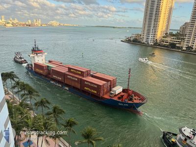
BELEN
General Cargo
Current Trip
DOHAI
| Time Travelled | 3 days |
|---|---|
| Remaining Time | --- |
| Distance Travelled | 806.73 nm |
| Remaining Distance | --- |
| AVG Speed | 11.4 Noeuds |
| MAX Speed | 13 Noeuds |
| AVG Wind | 11.3 knots |
| MAX Wind | 27.9 knots |
| MIN Temp | 21.4°C / 70.52°F |
| MAX Temp | 26.9°C / 80.42°F |
| Tirant d eau | 4.4 m |
| Position reçue | 3 d depuis |
Current Position
| Longitude | --- |
|---|---|
| Latitude | --- |
| Etat | Under way using engine |
| Vitesse | 11.4 Noeuds |
| Parcours | 215.8° |
| Zone | Caribbean Sea |
| Station | T-AIS |
| Position reçue | 3 d depuis |
Info
Information
The current position of BELEN is in Caribbean Sea with coordinates 18.31590° / -70.04307° as reported on 2025-02-15 02:42 by AIS to our vessel tracker app. The vessel's current speed is 11.4 Noeuds
The vessel BELEN (IMO: 9196230, MMSI: 334976000) is a General Cargo that was built in 1999 ( 26 Age ). It's sailing under the flag of [HN] Honduras.
In this page you can find informations about the vessels current position, last detected port calls, and current voyage information. If the vessels is not in coverage by AIS you will find the latest position.
The current position of BELEN is detected by our AIS receivers and we are not responsible for the reliability of the data. The last position was recorded while the vessel was in Coverage by the Ais receivers of our vessel tracking app.
The current draught of BELEN as reported by AIS is 4.4 meters
Weather
| Temperature | 23.9°C / 75.02°F |
|---|---|
| Wind Speed | 13 knots |
| Direction | 40° NE |
| Pressure | 1018.7 hPa |
| Humidity | 83.7 % |
| Cloud Coverage | 100 % |
Featured Company
Last Port Calls
| Port | Arrival | Departure | Time In Port |
|---|---|---|---|
| 2025-02-14 07:06 | 2025-02-15 02:03 | 18 h | |
| 2025-02-07 20:44 | 2025-02-07 21:51 | 1 h | |
| 2025-02-04 20:01 | 2025-02-05 12:09 | 16 h | |
| 2025-02-03 17:41 | 2025-02-04 01:07 | 7 h | |
| 2025-01-31 05:20 | 2025-01-31 06:44 | 1 h | |
| 2025-01-30 10:04 | 2025-01-30 11:06 | 1 h | |
| 2025-01-27 05:08 | 2025-01-27 13:03 | 7 h | |
| 2025-01-24 17:03 | 2025-01-26 00:36 | 1 d | |
| 2025-01-20 19:06 | 2025-01-20 19:31 | 25 m | |
| 2025-01-17 02:08 | 2025-01-17 03:07 | 59 m |
Most Visited Ports (Last year)
| Port | Arrivals | |
|---|---|---|
| 33 | ||
| 13 | ||
| 8 | ||
| 5 | ||
| 4 | ||
| 1 |
Last Trips
| Origin | Departure | Destination | Arrival | Distance | |
|---|---|---|---|---|---|
| 2025-02-07 16:51 | 2025-02-14 03:06 | 960.51 nm | |||
| 2025-02-05 07:09 | 2025-02-07 15:44 | 611.07 nm | |||
| 2025-02-03 20:07 | 2025-02-04 15:01 | 169.52 nm | |||
| 2025-01-31 01:44 | 2025-02-03 12:41 | 666.47 nm | |||
| 2025-01-30 06:06 | 2025-01-31 00:20 | 5.03 nm | |||
| 2025-01-27 09:03 | 2025-01-30 05:04 | 697.33 nm | |||
| 2025-01-25 20:36 | 2025-01-27 01:08 | 294.37 nm | |||
| 2025-01-20 14:31 | 2025-01-24 13:03 | 921.46 nm | |||
| 2025-01-16 22:07 | 2025-01-20 14:06 | 7.05 nm | |||
| 2025-01-13 08:03 | 2025-01-16 21:08 | 917.42 nm |
Events
| Heure | Evenement | Détails | Position/ Destination | Info |
|---|---|---|---|---|
| 2025-02-15 03:01 | Etat Changé | Default Under way using engine |
18.26572 / -70.07739
DOHAI
|
Vitesse: 11.4 kn Parcours: 215.8° |
| 2025-02-15 02:42 | Hors de la zone couverte |
18.31590 / -70.04307
Caribbean Sea
|
Vitesse: 11.4 kn Parcours: 215.8° |
|
| 2025-02-15 02:29 | Etat Changé | Under way using engine Default |
18.35118 / -70.01737
DOHAI
|
Vitesse: 11.1 kn Parcours: 181° |
| 2025-02-15 02:16 | Démarrage | 1.66 nm, South of RIO HAINA |
18.39093 / -70.01665
DOHAI
|
Vitesse: 9.6 kn Parcours: -1° |
| 2025-02-15 02:16 | Dans la zone couverte |
18.34998 / -70.01845
Caribbean Sea
|
Vitesse: 11.1 kn Parcours: 216.5° |
|
| 2025-02-15 02:03 | PORT DE DEPART |
|
18.39093 / -70.01665
DOHAI
|
Vitesse: 0.1 kn Parcours: -1° |
| 2025-02-14 07:06 | Port d'arrivée |
|
18.42447 / -70.01788
[DO] RIO HAINA
|
Vitesse: 7 kn Parcours: 296° |
| 2025-02-14 06:50 | Etat Changé | Default Under way using engine |
18.39731 / -70.00243
DOHAI
|
Vitesse: 1.9 kn Parcours: 511° |
| 2025-02-14 06:41 | Hors de la zone couverte |
18.39297 / -69.99778
Caribbean Sea
|
Vitesse: 1.9 kn Parcours: 67.4° |
|
| 2025-02-14 06:02 | Changement de zone | Domican Republic part of the Caribbean Sea Bahamas part of the North Atlantic Ocean |
18.33132 / -70.02810
Caribbean Sea
|
Vitesse: 9.4 kn Parcours: 23° |