
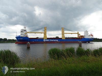
BBC RUBY
Cargo
Current Trip
| Time Travelled | 38 days |
|---|---|
| Remaining Time | --- |
| Distance Travelled | 10222.26 nm |
| Remaining Distance | --- |
| AVG Speed | 15 Noeuds |
| MAX Speed | 19.2 Noeuds |
| AVG Wind | 12 knots |
| MAX Wind | 33 knots |
| MIN Temp | 4.2°C / 39.56°F |
| MAX Temp | 28.8°C / 83.84°F |
| Tirant d eau | 8.2 m |
| Position reçue | 6 d depuis |
Current Position
| Longitude | --- |
|---|---|
| Latitude | --- |
| Etat | Under way using engine |
| Vitesse | 15.4 Noeuds |
| Parcours | 337.5° |
| Zone | South Atlantic Ocean |
| Station | T-AIS |
| Position reçue | 6 d depuis |
Info
Information
The current position of BBC RUBY is in South Atlantic Ocean with coordinates -34.08000° / 17.96207° as reported on 2026-02-23 08:47 by AIS to our vessel tracker app. The vessel's current speed is 15.4 Noeuds and is heading at the port of WALVIS BAY. The estimated time of arrival as calculated by MyShipTracking vessel tracking app is 2026-02-23 20:00 LT
The vessel BBC RUBY (IMO: 9563744, MMSI: 305908000) is a Cargo It's sailing under the flag of [AG] Antigua Barbuda.
In this page you can find informations about the vessels current position, last detected port calls, and current voyage information. If the vessels is not in coverage by AIS you will find the latest position.
The current position of BBC RUBY is detected by our AIS receivers and we are not responsible for the reliability of the data. The last position was recorded while the vessel was in Coverage by the Ais receivers of our vessel tracking app.
The current draught of BBC RUBY as reported by AIS is 8.2 meters
Weather
| Temperature | 27.2°C / 80.96°F |
|---|---|
| Wind Speed | 8 knots |
| Direction | 148° SSE |
| Pressure | 1007.6 hPa |
| Humidity | 68.9 % |
| Cloud Coverage | 27 % |
Featured Company
Last Trips
| Origin | Departure | Destination | Arrival | Distance | |
|---|---|---|---|---|---|
| 2026-01-19 21:17 | 2026-01-21 17:27 | 588.80 nm | |||
| 2025-12-28 10:03 | 2026-01-15 15:21 | 6538.02 nm |
Events
| Heure | Evenement | Détails | Position/ Destination | Info |
|---|---|---|---|---|
| 2026-02-25 19:48 | Démarrage | --- |
-22.88716 / 14.47979
NA WVB
|
Vitesse: 3.7 kn Parcours: 318° |
| 2026-02-25 09:36 | Arret | --- |
-22.88772 / 14.48297
NA WVB
|
Vitesse: Parcours: 250° |
| 2026-02-23 08:48 | Etat Changé | Default Under way using engine |
-34.07712 / 17.96059
NA WVB
|
Vitesse: 15.4 kn Parcours: 337.5° |
| 2026-02-23 08:47 | Hors de la zone couverte |
-34.08000 / 17.96207
South Atlantic Ocean
NA WVB
|
Vitesse: 15.4 kn Parcours: 337.5° |
|
| 2026-02-23 08:43 | Etat Changé | Under way using engine Default |
-34.09607 / 17.97028
NA WVB
|
Vitesse: 15.3 kn Parcours: 334° |
| 2026-02-23 08:40 | Etat Changé | Default Under way using engine |
-34.10864 / 17.97681
NA WVB
|
Vitesse: 15.3 kn Parcours: 333.4° |
| 2026-02-23 07:16 | Etat Changé | Under way using engine Default |
-34.39935 / 18.19201
NA WVB
|
Vitesse: 14.7 kn Parcours: 275° |
| 2026-02-23 07:08 | Etat Changé | Default Under way using engine |
-34.40379 / 18.23171
NA WVB
|
Vitesse: 14.7 kn Parcours: 289.7° |
| 2026-02-23 06:19 | Etat Changé | Under way using engine Default |
-34.48675 / 18.45817
NA WVB
|
Vitesse: 15.1 kn Parcours: 293° |
| 2026-02-23 06:06 | Etat Changé | Default Under way using engine |
-34.50678 / 18.51702
NA WVB
|
Vitesse: 14.9 kn Parcours: 292° |