
BAYREUTH
Pollution Control Vessel
Current Trip
| Time Travelled | 12 days |
|---|---|
| Remaining Time | 1 day |
| Distance Travelled | 436.55 nm |
| Remaining Distance | 332.12 nm |
| AVG Speed | 6.6 Noeuds |
| MAX Speed | 19.6 Noeuds |
| AVG Wind | 9.1 knots |
| MAX Wind | 16.8 knots |
| MIN Temp | 2.4°C / 36.32°F |
| MAX Temp | 13.2°C / 55.76°F |
| Tirant d eau | 3.4 m |
| Position reçue | 1 m depuis |
Current Position
| Longitude | 12.36725° |
|---|---|
| Latitude | 54.37810° |
| Etat | Under way using engine |
| Vitesse | |
| Parcours | 115° |
| Zone | Baltic Sea |
| Station | T-AIS |
| Position reçue | 1 m depuis |
Info
Information
The current position of BAYREUTH is in Baltic Sea with coordinates 54.37810° / 12.36725° as reported on 2024-04-28 04:44 by AIS to our vessel tracker app. The vessel's current speed is 0 Noeuds and is heading at the port of LIEPAJA. The estimated time of arrival as calculated by MyShipTracking vessel tracking app is 2024-04-29 06:15 LT
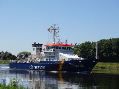
The vessel BAYREUTH (IMO: 9252632, MMSI: 211386450) is a Pollution Control Vessel that was built in 2003 ( 21 Age ). It's sailing under the flag of [DE] Germany.
In this page you can find informations about the vessels current position, last detected port calls, and current voyage information. If the vessels is not in coverage by AIS you will find the latest position.
The current position of BAYREUTH is detected by our AIS receivers and we are not responsible for the reliability of the data. The last position was recorded while the vessel was in Coverage by the Ais receivers of our vessel tracking app.
The current draught of BAYREUTH as reported by AIS is 3.4 meters
Weather
| Temperature | 9.5°C / 49.1°F |
|---|---|
| Wind Speed | 15 knots |
| Direction | 146° SE |
| Pressure | 1011.7 hPa |
| Humidity | 81.7 % |
| Cloud Coverage | 48 % |
Featured Company
Last Port Calls
| Port | Arrival | Departure | Time In Port |
|---|---|---|---|
| 2024-04-05 11:19 | 2024-04-15 07:50 | 9 d | |
| 2024-04-02 10:09 | 2024-04-02 15:13 | 5 h | |
| 2024-03-28 11:15 | 2024-03-28 16:22 | 5 h | |
| 2024-03-02 18:37 | 2024-03-03 08:13 | 13 h | |
| 2024-03-01 10:36 | 2024-03-01 13:46 | 3 h | |
| 2024-02-04 09:46 | 2024-02-04 10:36 | 49 m | |
| 2024-02-04 09:07 | 2024-02-04 09:42 | 35 m |
Most Visited Ports (Last year)
| Port | Arrivals | |
|---|---|---|
| 11 | ||
| 6 | ||
| 4 | ||
| 1 |
Last Trips
| Origin | Departure | Destination | Arrival | Distance | |
|---|---|---|---|---|---|
| 2024-04-02 17:13 | 2024-04-05 13:19 | 287.01 nm | |||
| 2024-03-28 17:22 | 2024-04-02 12:09 | 398.54 nm | |||
| 2024-03-03 09:13 | 2024-03-28 12:15 | 399.65 nm | |||
| 2024-03-01 14:46 | 2024-03-02 19:37 | 108.61 nm | |||
| 2024-02-04 11:36 | 2024-03-01 11:36 | 911.27 nm | |||
| 2024-02-04 10:42 | 2024-02-04 10:46 | 0.28 nm | |||
| 2024-01-31 16:14 | 2024-02-04 10:07 | 162.28 nm |
Events
| Heure | Evenement | Détails | Position/ Destination | Info |
|---|---|---|---|---|
| 2024-04-27 17:40 | Arret | 11.72 nm, West of ZINGST |
54.37798 / 12.36710
BALTIC SEA
|
Vitesse: 0.3 kn Parcours: 130° |
| 2024-04-27 05:01 | Démarrage | 2.36 nm, South East of BURGSTAAKEN |
54.37732 / 11.22127
BALTIC SEA
|
Vitesse: 3.1 kn Parcours: 220° |
| 2024-04-27 04:27 | Arret | 2.51 nm, South East of BURGSTAAKEN |
54.37463 / 11.22180
BALTIC SEA
|
Vitesse: 0.3 kn Parcours: 273° |
| 2024-04-26 08:53 | Dans la zone couverte |
54.67728 / 13.54913
Baltic Sea
BALTIC SEA
|
Vitesse: 8.6 kn Parcours: 357.7° |
|
| 2024-04-26 07:34 | Hors de la zone couverte |
54.59100 / 13.50250
Baltic Sea
BALTIC SEA
|
Vitesse: 7.2 kn Parcours: 81° |
|
| 2024-04-26 07:27 | Démarrage | 7.4 nm, North West of SASSNITZ |
54.58902 / 13.47768
BALTIC SEA
|
Vitesse: 7 kn Parcours: 81.3° |
| 2024-04-26 07:07 | Arret | 7.69 nm, North West of SASSNITZ |
54.58930 / 13.46768
BALTIC SEA
|
Vitesse: 0.3 kn Parcours: 240° |
| 2024-04-26 06:59 | Dans la zone couverte |
54.58910 / 13.46872
Baltic Sea
BALTIC SEA
|
Vitesse: 0.6 kn Parcours: 290.9° |
|
| 2024-04-26 05:35 | Hors de la zone couverte |
54.68623 / 13.48030
Baltic Sea
BALTIC SEA
|
Vitesse: 5.6 kn Parcours: 106.9° |
|
| 2024-04-25 16:43 | Dans la zone couverte |
54.18287 / 11.60153
Baltic Sea
BALTIC SEA
|
Vitesse: 11.9 kn Parcours: 71.6° |