
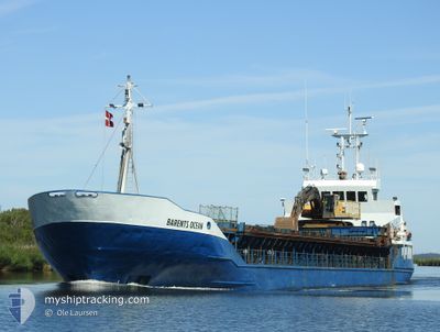
BARENTS OCEAN
General Cargo
Current Trip
TYTTEBERVIKA
| Time Travelled | 1 day |
|---|---|
| Remaining Time | --- |
| Distance Travelled | 101.62 nm |
| Remaining Distance | --- |
| AVG Speed | 8.7 Noeuds |
| MAX Speed | 9.6 Noeuds |
| AVG Wind | 6.6 knots |
| MAX Wind | 10.5 knots |
| MIN Temp | -18.5°C / -1.3°F |
| MAX Temp | -8°C / 17.6°F |
| Tirant d eau | 3.5 m |
| Position reçue | 1 m depuis |
Current Position
| Longitude | --- |
|---|---|
| Latitude | --- |
| Etat | Under way using engine |
| Vitesse | |
| Parcours | 265° |
| Zone | Norwegian Sea |
| Station | T-AIS |
| Position reçue | 1 m depuis |
Info
Information
The current position of BARENTS OCEAN is in Norwegian Sea with coordinates 69.59843° / 19.96150° as reported on 2026-01-10 18:07 by AIS to our vessel tracker app. The vessel's current speed is 0 Noeuds
The vessel BARENTS OCEAN (IMO: 8318063, MMSI: 257080050) is a General Cargo that was built in 1984 ( 42 Age ). It's sailing under the flag of [NO] Norway.
In this page you can find informations about the vessels current position, last detected port calls, and current voyage information. If the vessels is not in coverage by AIS you will find the latest position.
The current position of BARENTS OCEAN is detected by our AIS receivers and we are not responsible for the reliability of the data. The last position was recorded while the vessel was in Coverage by the Ais receivers of our vessel tracking app.
The current draught of BARENTS OCEAN as reported by AIS is 3.5 meters
Weather
| Temperature | -17.2°C / 1.04°F |
|---|---|
| Wind Speed | 12 knots |
| Direction | 193° SSW |
| Pressure | 1020.9 hPa |
| Humidity | 80.4 % |
| Cloud Coverage | 2 % |
Featured Company
Last Port Calls
| Port | Arrival | Departure | Time In Port |
|---|---|---|---|
| 2026-01-09 08:23 | 2026-01-09 19:06 | 10 h | |
| 2026-01-08 07:07 | 2026-01-08 19:03 | 11 h | |
| 2026-01-06 14:36 | 2026-01-07 01:38 | 11 h | |
| 2025-12-18 20:37 | 2026-01-04 17:40 | 16 d | |
| 2025-12-18 05:59 | 2025-12-18 16:07 | 10 h | |
| 2025-12-12 06:58 | 2025-12-12 13:50 | 6 h | |
| 2025-12-11 07:04 | 2025-12-11 09:34 | 2 h | |
| 2025-12-05 17:14 | 2025-12-06 09:07 | 15 h | |
| 2025-12-05 13:19 | 2025-12-05 13:34 | 14 m | |
| 2025-12-04 18:48 | 2025-12-04 23:30 | 4 h |
Last Trips
| Origin | Departure | Destination | Arrival | Distance | |
|---|---|---|---|---|---|
| 2026-01-08 19:03 | 2026-01-09 08:23 | 65.36 nm | |||
| 2026-01-07 01:38 | 2026-01-08 07:07 | 184.56 nm | |||
| 2026-01-04 17:40 | 2026-01-06 14:36 | 230.19 nm | |||
| 2025-12-18 16:07 | 2025-12-18 20:37 | 37.00 nm | |||
| 2025-12-12 13:50 | 2025-12-18 05:59 | 471.01 nm | |||
| 2025-12-11 09:34 | 2025-12-12 06:58 | 71.64 nm | |||
| 2025-12-06 09:07 | 2025-12-11 07:04 | 406.57 nm | |||
| 2025-12-05 13:34 | 2025-12-05 17:14 | 30.16 nm | |||
| 2025-12-04 23:30 | 2025-12-05 13:19 | 116.47 nm | |||
| 2025-12-04 18:21 | 2025-12-04 18:48 | 3.80 nm |
Events
| Heure | Evenement | Détails | Position/ Destination | Info |
|---|---|---|---|---|
| 2026-01-10 15:22 | Arret | 21.04 nm, East of TROMSO |
69.59841 / 19.96157
TYTTEBERVIKA
|
Vitesse: 0.1 kn Parcours: 266° |
| 2026-01-10 11:27 | Démarrage | 2.27 nm, North East of TROMSO |
69.70147 / 19.03170
TYTTEBERVIKA
|
Vitesse: 7.6 kn Parcours: 49.5° |
| 2026-01-10 11:16 | Tirant d'eau modifié | 3.5 4.2 |
69.69881 / 19.02147
TYTTEBERVIKA
|
Vitesse: Parcours: 5° |
| 2026-01-10 11:16 | Changement de destination | TYTTEBERVIKA TROMSO |
69.69881 / 19.02147
TYTTEBERVIKA
|
Vitesse: Parcours: 5° |
| 2026-01-10 11:16 | Changement d'ETA | 2026/01/10 16:30 2026/10/01 07:30 |
69.69881 / 19.02147
TYTTEBERVIKA
|
Vitesse: Parcours: 5° |
| 2026-01-10 06:51 | Arret | 2.04 nm, North East of TROMSO |
69.69869 / 19.02350
TROMSO
|
Vitesse: 0.1 kn Parcours: 322° |
| 2026-01-10 03:22 | Tirant d'eau modifié | 4.2 4.5 |
69.63275 / 19.80818
TROMSO
|
Vitesse: 8.5 kn Parcours: 335.7° |
| 2026-01-10 03:22 | Changement d'ETA | 2026/10/01 07:30 2026/12/06 10:01 |
69.63275 / 19.80818
TROMSO
|
Vitesse: 8.5 kn Parcours: 335.7° |
| 2026-01-10 02:54 | Démarrage | 20.84 nm, East of TROMSO |
69.59679 / 19.95078
TROMSO
|
Vitesse: 7 kn Parcours: 262.4° |
| 2026-01-09 23:17 | Etat Changé | Under way using engine Moored |
69.59845 / 19.96157
TROMSO
|
Vitesse: Parcours: 264° |