
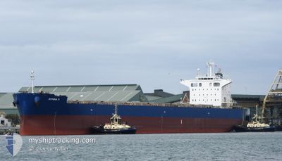
ATHINA III
Bulk Carrier
Current Trip
| Time Travelled | 14 days |
|---|---|
| Remaining Time | --- |
| Distance Travelled | 4189.43 nm |
| Remaining Distance | --- |
| AVG Speed | 12.1 Noeuds |
| MAX Speed | 15.2 Noeuds |
| AVG Wind | 11.2 knots |
| MAX Wind | 31.2 knots |
| MIN Temp | 8.8°C / 47.84°F |
| MAX Temp | 30.4°C / 86.72°F |
| Tirant d eau | 7.3 m |
| Position reçue | 1 m depuis |
Current Position
| Longitude | 27.66483° |
|---|---|
| Latitude | 40.72368° |
| Etat | Under way using engine |
| Vitesse | 12.3 Noeuds |
| Parcours | 83° |
| Zone | Sea of Marmara |
| Station | T-AIS |
| Position reçue | 1 m depuis |
Info
Information
The current position of ATHINA III is in Sea of Marmara with coordinates 40.72368° / 27.66483° as reported on 2024-05-15 00:18 by AIS to our vessel tracker app. The vessel's current speed is 12.3 Noeuds and is heading at the port of CANAKKALE. The estimated time of arrival as calculated by MyShipTracking vessel tracking app is 2024-05-14 17:00 LT
The vessel ATHINA III (IMO: 9247285, MMSI: 215015000) is a Bulk Carrier that was built in 2004 ( 20 Age ). It's sailing under the flag of [MT] Malta.
In this page you can find informations about the vessels current position, last detected port calls, and current voyage information. If the vessels is not in coverage by AIS you will find the latest position.
The current position of ATHINA III is detected by our AIS receivers and we are not responsible for the reliability of the data. The last position was recorded while the vessel was in Coverage by the Ais receivers of our vessel tracking app.
The current draught of ATHINA III as reported by AIS is 7.3 meters
Weather
| Temperature | 14.5°C / 58.1°F |
|---|---|
| Wind Speed | 9 knots |
| Direction | 66° ENE |
| Pressure | 1017 hPa |
| Humidity | 55.7 % |
| Cloud Coverage | 48 % |
Featured Company
Last Port Calls
| Port | Arrival | Departure | Time In Port |
|---|---|---|---|
| 2024-05-12 05:11 | 2024-05-12 14:25 | 9 h | |
| 2024-04-19 07:03 | 2024-04-30 08:28 | 11 d | |
| 2024-04-02 04:08 | 2024-04-02 13:03 | 8 h | |
| 2024-03-28 17:44 | 2024-03-28 19:01 | 1 h | |
| 2024-03-19 08:43 | 2024-03-26 23:11 | 7 d | |
| 2024-03-12 04:19 | 2024-03-12 13:53 | 9 h |
Most Visited Ports (Last year)
| Port | Arrivals | |
|---|---|---|
| 7 | ||
| 3 | ||
| 2 | ||
| 1 | ||
| 1 | ||
| 1 |
Last Trips
| Origin | Departure | Destination | Arrival | Distance | |
|---|---|---|---|---|---|
| 2024-04-30 12:58 | 2024-05-12 07:11 | 3362.52 nm | |||
| 2024-03-28 22:01 | 2024-04-19 11:33 | 4281.80 nm | |||
| 2024-03-28 22:01 | 2024-04-02 06:08 | 832.06 nm | |||
| 2024-03-27 01:11 | 2024-03-28 20:44 | 210.02 nm | |||
| 2024-02-29 13:49 | 2024-03-19 10:43 | 4382.10 nm | |||
| 2024-02-29 13:49 | 2024-03-12 06:19 | 3164.52 nm |
Events
| Heure | Evenement | Détails | Position/ Destination | Info |
|---|---|---|---|---|
| 2024-05-14 21:48 | Etat Changé | Under way using engine Default |
40.51978 / 27.02837
DARDANELLES
|
Vitesse: 12.7 kn Parcours: 65° |
| 2024-05-14 21:48 | Dans la zone couverte |
40.52228 / 27.03548
Sea of Marmara
DARDANELLES
|
Vitesse: 12.8 kn Parcours: 64° |
|
| 2024-05-14 20:16 | Etat Changé | Default Under way using engine |
40.37730 / 26.67438
DARDANELLES
|
Vitesse: 11.3 kn Parcours: 35° |
| 2024-05-14 20:08 | Hors de la zone couverte |
40.35870 / 26.65705
Sea of Marmara
DARDANELLES
|
Vitesse: 11.3 kn Parcours: 35° |
|
| 2024-05-14 17:29 | Detecté en mer | Turkish part of the Sea of Marmara |
40.01775 / 26.19210
Sea of Marmara
DARDANELLES
|
Vitesse: 6.8 kn Parcours: 75° |
| 2024-05-14 17:07 | Changement de zone | Turkish part of the Aegean Sea Greek part of the Aegean Sea |
40.00648 / 26.13710
Aegean Sea
DARDANELLES
|
Vitesse: 11.2 kn Parcours: 73° |
| 2024-05-14 17:07 | Dans la zone couverte |
40.00648 / 26.13710
Aegean Sea
DARDANELLES
|
Vitesse: 11.2 kn Parcours: 73° |
|
| 2024-05-14 17:05 | Etat Changé | Under way using engine Default |
40.00477 / 26.12910
DARDANELLES
|
Vitesse: 11.5 kn Parcours: 73° |
| 2024-05-14 15:49 | Etat Changé | Default Under way using engine |
39.84737 / 25.87075
DARDANELLES
|
Vitesse: 13.3 kn Parcours: 9° |
| 2024-05-14 15:41 | Hors de la zone couverte |
39.82080 / 25.85475
Aegean Sea
DARDANELLES
|
Vitesse: 13.3 kn Parcours: 9° |