
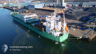
ARKLOW ROVER
Cargo
Current Trip
| Time Travelled | 3 days |
|---|---|
| Remaining Time | --- |
| Distance Travelled | 996.60 nm |
| Remaining Distance | --- |
| AVG Speed | 11.1 Noeuds |
| MAX Speed | 13.4 Noeuds |
| AVG Wind | 10 knots |
| MAX Wind | 20.7 knots |
| MIN Temp | 4.9°C / 40.82°F |
| MAX Temp | 11.2°C / 52.16°F |
| Tirant d eau | 6.7 m |
| Position reçue | 1 m depuis |
Current Position
| Longitude | --- |
|---|---|
| Latitude | --- |
| Etat | Under way using engine |
| Vitesse | 0.1 Noeuds |
| Parcours | 112° |
| Zone | Celtic Sea |
| Station | T-AIS |
| Position reçue | 1 m depuis |
Info
Information
The current position of ARKLOW ROVER is in Celtic Sea with coordinates 52.13592° / -6.96302° as reported on 2025-03-11 14:49 by AIS to our vessel tracker app. The vessel's current speed is 0.1 Noeuds
The vessel ARKLOW ROVER (IMO: 9923279, MMSI: 250014194) is a Cargo It's sailing under the flag of [IE] Ireland.
In this page you can find informations about the vessels current position, last detected port calls, and current voyage information. If the vessels is not in coverage by AIS you will find the latest position.
The current position of ARKLOW ROVER is detected by our AIS receivers and we are not responsible for the reliability of the data. The last position was recorded while the vessel was in Coverage by the Ais receivers of our vessel tracking app.
The current draught of ARKLOW ROVER as reported by AIS is 6.7 meters
Weather
| Temperature | 8.1°C / 46.58°F |
|---|---|
| Wind Speed | 9 knots |
| Direction | 48° NE |
| Pressure | 1011.7 hPa |
| Humidity | 56.2 % |
| Cloud Coverage | 97 % |
Featured Company
Last Port Calls
| Port | Arrival | Departure | Time In Port |
|---|---|---|---|
| 2025-03-06 21:52 | 2025-03-07 19:54 | 22 h | |
| 2025-03-01 12:23 | 2025-03-03 22:59 | 2 d | |
| 2025-02-20 08:29 | 2025-02-21 20:29 | 1 d | |
| 2025-02-17 22:35 | 2025-02-17 23:06 | 31 m | |
| 2025-02-15 10:31 | 2025-02-17 22:01 | 2 d | |
| 2025-02-15 09:06 | 2025-02-15 09:40 | 34 m | |
| 2025-02-13 18:54 | 2025-02-13 21:21 | 2 h | |
| 2025-02-11 18:45 | 2025-02-13 18:18 | 1 d | |
| 2025-02-06 17:28 | |||
| 2025-02-02 11:09 | 2025-02-05 22:49 | 3 d |
Most Visited Ports (Last year)
| Port | Arrivals | |
|---|---|---|
| 2 | ||
| 2 | ||
| 2 | ||
| 2 | ||
| 2 | ||
| 2 |
Last Trips
| Origin | Departure | Destination | Arrival | Distance | |
|---|---|---|---|---|---|
| 2025-03-03 22:59 | 2025-03-06 22:52 | 815.27 nm | |||
| 2025-02-21 21:29 | 2025-03-01 12:23 | 1005.05 nm | |||
| 2025-02-18 00:06 | 2025-02-20 09:29 | 594.72 nm | |||
| 2025-02-17 23:01 | 2025-02-17 23:35 | 2.98 nm | |||
| 2025-02-15 10:40 | 2025-02-15 11:31 | 3.57 nm | |||
| 2025-02-13 22:21 | 2025-02-15 10:06 | 276.52 nm | |||
| 2025-02-13 19:18 | 2025-02-13 19:54 | 4.49 nm | |||
| 2025-02-05 23:49 | 2025-02-06 18:28 | 225.73 nm | |||
| 2025-01-29 17:25 | 2025-02-02 12:09 | 871.45 nm | |||
| 2025-01-20 20:53 | 2025-01-22 13:23 | 460.28 nm |
Events
| Heure | Evenement | Détails | Position/ Destination | Info |
|---|---|---|---|---|
| 2025-03-11 12:04 | Arret | 1.3 nm, South East of DUNMORE EAST |
52.13603 / -6.96139
WATERFORD
|
Vitesse: 0.3 kn Parcours: 159° |
| 2025-03-11 10:32 | Changement de zone | Irish part of the Celtic Sea United Kingdom part of the Celtic Sea |
51.89338 / -6.86856
Celtic Sea
WATERFORD
|
Vitesse: 10.6 kn Parcours: 338.7° |
| 2025-03-11 10:32 | Dans la zone couverte |
51.89338 / -6.86856
Celtic Sea
WATERFORD
|
Vitesse: 10.6 kn Parcours: 338.7° |
|
| 2025-03-11 02:06 | Hors de la zone couverte |
50.45653 / -5.96406
Celtic Sea
WATERFORD
|
Vitesse: 11.5 kn Parcours: 339° |
|
| 2025-03-10 23:58 | Detecté en mer | United Kingdom part of the Celtic Sea |
50.04042 / -5.87000
Celtic Sea
WATERFORD
|
Vitesse: 12 kn Parcours: 348.3° |
| 2025-03-10 23:58 | Dans la zone couverte |
50.04042 / -5.87000
Celtic Sea
WATERFORD
|
Vitesse: 12 kn Parcours: 348.3° |
|
| 2025-03-10 22:37 | Hors de la zone couverte |
49.95038 / -5.52187
English Channel
WATERFORD
|
Vitesse: 11.5 kn Parcours: 280.9° |
|
| 2025-03-10 15:12 | Dans la zone couverte |
50.12469 / -3.40794
English Channel
WATERFORD
|
Vitesse: 10.8 kn Parcours: 259.5° |
|
| 2025-03-10 13:41 | Hors de la zone couverte |
50.19229 / -2.97895
English Channel
WATERFORD
|
Vitesse: 11.7 kn Parcours: 260.9° |
|
| 2025-03-10 11:48 | Dans la zone couverte |
50.25533 / -2.37321
English Channel
WATERFORD
|
Vitesse: 13.4 kn Parcours: 259.8° |