

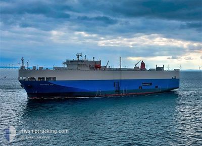
AQUARIUS ACE
Ro-Ro/Passenger Ship

Current Trip
| Time Travelled | 1 day |
|---|---|
| Remaining Time | 1 h, 14 mins |
| Distance Travelled | 399.22 nm |
| Remaining Distance | 14.23 nm |
| AVG Speed | 13.2 Noeuds |
| MAX Speed | 17.4 Noeuds |
| AVG Wind | 8.5 knots |
| MAX Wind | 14 knots |
| MIN Temp | -3.5°C / 25.7°F |
| MAX Temp | 9°C / 48.2°F |
| Tirant d eau | 7.1 m |
| Position reçue | Maintenant |
Current Position
| Longitude | --- |
|---|---|
| Latitude | --- |
| Etat | Under way using engine |
| Vitesse | 2.8 Noeuds |
| Parcours | 336° |
| Zone | Aegean Sea |
| Station | T-AIS |
| Position reçue | Maintenant |
Information
The current position of AQUARIUS ACE is in Aegean Sea with coordinates 37.74130° / 23.72225° as reported on 2025-02-24 02:53 by AIS to our vessel tracker app. The vessel's current speed is 2.8 Noeuds and is heading at the port of PIRAEUS. The estimated time of arrival as calculated by MyShipTracking vessel tracking app is 2025-02-24 04:07 LT
The vessel AQUARIUS ACE (IMO: 9150339, MMSI: 354123000) is a Ro-Ro/Passenger Ship that was built in 1998 ( 27 Age ). It's sailing under the flag of [PA] Panama.
In this page you can find informations about the vessels current position, last detected port calls, and current voyage information. If the vessels is not in coverage by AIS you will find the latest position.
The current position of AQUARIUS ACE is detected by our AIS receivers and we are not responsible for the reliability of the data. The last position was recorded while the vessel was in Coverage by the Ais receivers of our vessel tracking app.
The current draught of AQUARIUS ACE as reported by AIS is 7.1 meters
Weather
| Temperature | 7.9°C / 46.22°F |
|---|---|
| Wind Speed | 5 knots |
| Direction | 55° NE |
| Pressure | 1030.8 hPa |
| Humidity | 67.5 % |
| Cloud Coverage | 46 % |


Featured Company
Last Port Calls
| Port | Arrival | Departure | Time In Port |
|---|---|---|---|
| 2025-02-22 11:37 | 2025-02-22 20:03 | 8 h | |
| 2025-02-10 18:45 | 2025-02-12 07:43 | 1 d | |
| 2025-02-08 03:37 | 2025-02-09 14:19 | 1 d | |
| 2025-01-31 06:59 | 2025-02-01 13:52 | 1 d | |
| 2025-01-27 11:50 | 2025-01-28 07:12 | 19 h | |
| 2025-01-19 11:21 | 2025-01-21 07:32 | 1 d | |
| 2025-01-17 12:06 | 2025-01-18 14:50 | 1 d | |
| 2025-01-10 09:57 | 2025-01-11 00:30 | 14 h | |
| 2025-01-06 08:25 | 2025-01-06 18:31 | 10 h | |
| 2025-01-03 04:16 | 2025-01-03 13:04 | 8 h |
Last Trips
| Origin | Departure | Destination | Arrival | Distance | |
|---|---|---|---|---|---|
| 2025-02-12 07:43 | 2025-02-22 14:37 | 3467.35 nm | |||
| 2025-02-09 15:19 | 2025-02-10 18:45 | 297.28 nm | |||
| 2025-02-01 14:52 | 2025-02-08 04:37 | 2225.90 nm | |||
| 2025-01-28 08:12 | 2025-01-31 07:59 | 483.71 nm | |||
| 2025-01-21 07:32 | 2025-01-27 12:50 | 2121.43 nm | |||
| 2025-01-18 15:50 | 2025-01-19 11:21 | 295.71 nm | |||
| 2025-01-11 01:30 | 2025-01-17 13:06 | 2284.55 nm | |||
| 2025-01-06 18:31 | 2025-01-10 10:57 | 1208.11 nm | |||
| 2025-01-03 14:04 | 2025-01-06 08:25 | 646.56 nm | |||
| 2024-12-30 12:17 | 2025-01-03 05:16 | 951.43 nm |
Events
| Heure | Evenement | Détails | Position/ Destination | Info |
|---|---|---|---|---|
| 2025-02-24 01:47 | Changement d'ETA | 2025/02/24 04:00 2026/01/01 04:00 |
37.66324 / 23.77430
GRPIR
|
Vitesse: 10.7 kn Parcours: 326.5° |
| 2025-02-24 01:41 | Changement d'ETA | 2026/01/01 04:00 2025/02/24 04:00 |
37.64926 / 23.78823
GRPIR
|
Vitesse: 10.6 kn Parcours: 317.5° |
| 2025-02-23 21:46 | Etat Changé | Under way using engine Default |
37.96520 / 24.60409
GRPIR
|
Vitesse: 13.5 kn Parcours: 208° |
| 2025-02-23 21:46 | Dans la zone couverte |
37.96520 / 24.60409
Aegean Sea
GRPIR
|
Vitesse: 13.5 kn Parcours: 235.3° |
|
| 2025-02-23 16:45 | Etat Changé | Default Under way using engine |
39.03670 / 25.27105
GRPIR
|
Vitesse: 14.6 kn Parcours: 207.1° |
| 2025-02-23 16:32 | Hors de la zone couverte |
39.08267 / 25.29986
Aegean Sea
GRPIR
|
Vitesse: 14.6 kn Parcours: 207.1° |
|
| 2025-02-23 16:24 | Etat Changé | Under way using engine Default |
39.11310 / 25.31987
GRPIR
|
Vitesse: 15.6 kn Parcours: 206° |
| 2025-02-23 16:13 | Etat Changé | Default Under way using engine |
39.15535 / 25.34716
GRPIR
|
Vitesse: 15.4 kn Parcours: 206.6° |
| 2025-02-23 16:06 | Etat Changé | Under way using engine Default |
39.18120 / 25.36336
GRPIR
|
Vitesse: 15.6 kn Parcours: 207° |
| 2025-02-23 15:59 | Etat Changé | Default Under way using engine |
39.20683 / 25.38013
GRPIR
|
Vitesse: 15.6 kn Parcours: 201.6° |