
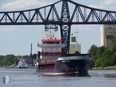
AMBER SPIRIT
General Cargo
Current Trip
| Time Travelled | 2 days |
|---|---|
| Remaining Time | --- |
| Distance Travelled | 468.03 nm |
| Remaining Distance | 27.34 nm |
| AVG Speed | 10.9 Noeuds |
| MAX Speed | 11.6 Noeuds |
| AVG Wind | 6.9 knots |
| MAX Wind | 14.8 knots |
| MIN Temp | 5.7°C / 42.26°F |
| MAX Temp | 9.2°C / 48.56°F |
| Tirant d eau | 4.9 m |
| Position reçue | 3 h, 24 m depuis |
Current Position
| Longitude | 29.31765° |
|---|---|
| Latitude | 60.01360° |
| Etat | At anchor |
| Vitesse | |
| Parcours | 101° |
| Zone | Gulf of Finland |
| Station | T-AIS |
| Position reçue | 3 h, 24 m depuis |
Info
Information
The current position of AMBER SPIRIT is in Gulf of Finland with coordinates 60.01360° / 29.31765° as reported on 2024-05-14 07:12 by AIS to our vessel tracker app. The vessel's current speed is 0 Noeuds and is heading at the port of ST PETERSBURG. The estimated time of arrival as calculated by MyShipTracking vessel tracking app is 2024-05-13 14:00 LT
The vessel AMBER SPIRIT (IMO: 9142643, MMSI: 305391000) is a General Cargo that was built in 1997 ( 27 Age ). It's sailing under the flag of [AG] Antigua Barbuda.
In this page you can find informations about the vessels current position, last detected port calls, and current voyage information. If the vessels is not in coverage by AIS you will find the latest position.
The current position of AMBER SPIRIT is detected by our AIS receivers and we are not responsible for the reliability of the data. The last position was recorded while the vessel was in Coverage by the Ais receivers of our vessel tracking app.
The current draught of AMBER SPIRIT as reported by AIS is 4.9 meters
Weather
| Temperature | 9.2°C / 48.56°F |
|---|---|
| Wind Speed | 10 knots |
| Direction | 63° ENE |
| Pressure | 1022.7 hPa |
| Humidity | 79 % |
| Cloud Coverage | 97 % |
Featured Company
Last Port Calls
| Port | Arrival | Departure | Time In Port |
|---|---|---|---|
| 2024-05-09 11:40 | 2024-05-11 18:33 | 2 d | |
| 2024-05-07 19:40 | 2024-05-08 22:33 | 1 d | |
| 2024-05-05 15:01 | 2024-05-05 15:16 | 15 m | |
| 2024-05-04 09:48 | 2024-05-05 14:04 | 1 d | |
| 2024-05-04 08:44 | 2024-05-04 09:01 | 17 m | |
| 2024-05-03 04:57 | 2024-05-03 20:19 | 15 h | |
| 2024-04-30 17:14 | 2024-05-01 10:12 | 16 h | |
| 2024-04-27 02:07 | 2024-04-27 02:19 | 12 m | |
| 2024-04-24 18:23 | 2024-04-25 17:58 | 23 h | |
| 2024-04-22 13:22 | 2024-04-23 06:01 | 16 h |
Most Visited Ports (Last year)
| Port | Arrivals | |
|---|---|---|
| 14 | ||
| 12 | ||
| 6 | ||
| 6 | ||
| 5 | ||
| 5 |
Last Trips
| Origin | Departure | Destination | Arrival | Distance | |
|---|---|---|---|---|---|
| 2024-05-09 00:33 | 2024-05-09 14:40 | 122.16 nm | |||
| 2024-05-05 18:16 | 2024-05-07 21:40 | 542.37 nm | |||
| 2024-05-05 17:04 | 2024-05-05 18:01 | 7.65 nm | |||
| 2024-05-04 12:01 | 2024-05-04 12:48 | 3.51 nm | |||
| 2024-05-03 23:19 | 2024-05-04 11:44 | 106.90 nm | |||
| 2024-05-01 13:12 | 2024-05-03 07:57 | 308.00 nm | |||
| 2024-04-27 04:19 | 2024-04-30 20:14 | 839.93 nm | |||
| 2024-04-25 19:58 | 2024-04-27 04:07 | 342.96 nm | |||
| 2024-04-23 08:01 | 2024-04-24 20:23 | 347.80 nm | |||
| 2024-04-17 14:36 | 2024-04-22 15:22 | 619.38 nm |
Events
| Heure | Evenement | Détails | Position/ Destination | Info |
|---|---|---|---|---|
| 2024-05-14 07:16 | Etat Changé | Default At anchor |
60.01350 / 29.31762
ST PETERSBURG
|
Vitesse: Parcours: 101° |
| 2024-05-14 07:12 | Hors de la zone couverte |
60.01360 / 29.31765
Gulf of Finland
|
Vitesse: Parcours: 101° |
|
| 2024-05-14 07:12 | Dans la zone couverte |
60.01360 / 29.31765
Gulf of Finland
|
Vitesse: Parcours: 101° |
|
| 2024-05-14 05:32 | Etat Changé | Default At anchor |
60.01395 / 29.31759
ST PETERSBURG
|
Vitesse: 1 kn Parcours: 122° |
| 2024-05-14 05:22 | Hors de la zone couverte |
60.01395 / 29.31767
Gulf of Finland
|
Vitesse: 1 kn Parcours: 122° |
|
| 2024-05-14 05:01 | Etat Changé | At anchor Default |
60.01380 / 29.31770
ST PETERSBURG
|
Vitesse: 0.3 kn Parcours: 124° |
| 2024-05-14 04:43 | Etat Changé | Default At anchor |
60.01377 / 29.31779
ST PETERSBURG
|
Vitesse: 0.1 kn Parcours: 124° |
| 2024-05-14 04:31 | Etat Changé | At anchor Default |
60.01374 / 29.31778
ST PETERSBURG
|
Vitesse: 0.6 kn Parcours: 122° |
| 2024-05-14 04:22 | Etat Changé | Default At anchor |
60.01380 / 29.31775
ST PETERSBURG
|
Vitesse: Parcours: 124° |
| 2024-05-14 03:33 | Etat Changé | At anchor Default |
60.01384 / 29.31783
ST PETERSBURG
|
Vitesse: 0.3 kn Parcours: 125° |