
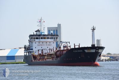
ALSIA SWAN
Oil/Chemical Tanker
Current Trip
| Time Travelled | 6 days |
|---|---|
| Remaining Time | --- |
| Distance Travelled | 1352.14 nm |
| Remaining Distance | --- |
| AVG Speed | 10.5 Noeuds |
| MAX Speed | 13.8 Noeuds |
| AVG Wind | 12.6 knots |
| MAX Wind | 30.9 knots |
| MIN Temp | 25.2°C / 77.36°F |
| MAX Temp | 28.8°C / 83.84°F |
| Tirant d eau | 5.4 m |
| Position reçue | 19 h, 25 m depuis |
Current Position
| Longitude | -94.43527° |
|---|---|
| Latitude | 29.19264° |
| Etat | Under way using engine |
| Vitesse | 10 Noeuds |
| Parcours | 303.8° |
| Zone | Gulf of Mexico |
| Station | T-AIS |
| Position reçue | 19 h, 25 m depuis |
Info
Information
The current position of ALSIA SWAN is in Gulf of Mexico with coordinates 29.19264° / -94.43527° as reported on 2024-06-20 10:55 by AIS to our vessel tracker app. The vessel's current speed is 10 Noeuds
The vessel ALSIA SWAN (IMO: 9400356, MMSI: 248359000) is a Oil/Chemical Tanker that was built in 2009 ( 15 Age ). It's sailing under the flag of [MT] Malta.
In this page you can find informations about the vessels current position, last detected port calls, and current voyage information. If the vessels is not in coverage by AIS you will find the latest position.
The current position of ALSIA SWAN is detected by our AIS receivers and we are not responsible for the reliability of the data. The last position was recorded while the vessel was in Coverage by the Ais receivers of our vessel tracking app.
The current draught of ALSIA SWAN as reported by AIS is 5.4 meters
Weather
| Temperature | 28.1°C / 82.58°F |
|---|---|
| Wind Speed | 18 knots |
| Direction | 108° ESE |
| Pressure | 1018.1 hPa |
| Humidity | 78.7 % |
| Cloud Coverage | 3 % |
Featured Company
Last Port Calls
| Port | Arrival | Departure | Time In Port |
|---|---|---|---|
| 2024-06-14 08:21 | 2024-06-14 19:48 | 11 h | |
| 2024-06-12 11:29 | 2024-06-13 09:28 | 21 h | |
| 2024-05-28 07:20 | 2024-05-30 22:05 | 2 d | |
| 2024-05-22 19:07 | 2024-05-23 13:35 | 18 h | |
| 2024-05-17 02:11 | 2024-05-19 16:49 | 2 d | |
| 2024-05-07 22:30 | 2024-05-10 03:38 | 2 d | |
| 2024-05-07 00:49 | 2024-05-07 00:53 | 3 m | |
| 2024-04-27 14:15 | 2024-04-27 22:55 | 8 h | |
| 2024-04-23 22:22 | 2024-04-24 08:06 | 9 h |
Most Visited Ports (Last year)
| Port | Arrivals | |
|---|---|---|
| 4 | ||
| 4 | ||
| 3 | ||
| 2 | ||
| 2 | ||
| 2 |
Last Trips
| Origin | Departure | Destination | Arrival | Distance | |
|---|---|---|---|---|---|
| 2024-06-13 09:28 | 2024-06-14 08:21 | 229.86 nm | |||
| 2024-05-30 22:05 | 2024-06-12 11:29 | 3465.29 nm | |||
| 2024-05-23 13:35 | 2024-05-28 07:20 | 897.89 nm | |||
| 2024-05-19 16:49 | 2024-05-22 19:07 | 777.05 nm | |||
| 2024-05-10 03:38 | 2024-05-17 02:11 | 936.61 nm | |||
| 2024-05-07 00:53 | 2024-05-07 22:30 | 240.25 nm | |||
| 2024-04-27 22:55 | 2024-05-07 00:49 | 2085.90 nm | |||
| 2024-04-24 08:06 | 2024-04-27 14:15 | 863.91 nm | |||
| 2024-03-27 14:12 | 2024-04-23 22:22 | 4597.65 nm |
Events
| Heure | Evenement | Détails | Position/ Destination | Info |
|---|---|---|---|---|
| 2024-06-20 12:22 | Arret | 10.34 nm, South East of BOLIVAR |
29.31295 / -94.59097
USHOU
|
Vitesse: 0.3 kn Parcours: 79° |
| 2024-06-20 10:59 | Etat Changé | Default Under way using engine |
29.19991 / -94.44737
USHOU
|
Vitesse: 10 kn Parcours: 303.8° |
| 2024-06-20 10:55 | Changement de zone | United States part of the Gulf of Mexico United States part of the North Atlantic Ocean |
29.19264 / -94.43527
Gulf of Mexico
|
Vitesse: 10 kn Parcours: 303.8° |
| 2024-06-20 10:55 | Etat Changé | Under way using engine Default |
29.19264 / -94.43527
USHOU
|
Vitesse: 10 kn Parcours: 304° |
| 2024-06-20 10:55 | Hors de la zone couverte |
29.19264 / -94.43527
Gulf of Mexico
|
Vitesse: 10 kn Parcours: 303.8° |
|
| 2024-06-20 10:43 | Dans la zone couverte |
29.19264 / -94.43527
Gulf of Mexico
|
Vitesse: 10 kn Parcours: 303.8° |
|
| 2024-06-17 01:13 | Etat Changé | Default Under way using engine |
24.46987 / -80.63912
USHOU
|
Vitesse: 9.9 kn Parcours: 242.6° |
| 2024-06-17 01:05 | Hors de la zone couverte |
24.48008 / -80.61735
North Atlantic Ocean
USHOU
|
Vitesse: 9.9 kn Parcours: 242.6° |
|
| 2024-06-16 21:05 | Dans la zone couverte |
24.87431 / -80.04847
North Atlantic Ocean
USHOU
|
Vitesse: 10 kn Parcours: 213.6° |
|
| 2024-06-16 18:06 | Hors de la zone couverte |
25.30283 / -79.81652
North Atlantic Ocean
USHOU
|
Vitesse: 9.3 kn Parcours: 185° |