
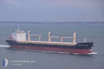
ALICIA G
Bulk Carrier
Current Trip
| Trip Time | --- |
|---|---|
| Trip Distance | --- |
| AVG Speed | --- |
| MAX Speed | --- |
| Tirant d eau | --- |
| AVG Wind | --- |
| MAX Wind | --- |
| MIN Temp | --- |
| MAX Temp | --- |
| Position reçue | 4 d depuis |
Current Position
| Longitude | --- |
|---|---|
| Latitude | --- |
| Etat | Under way using engine |
| Vitesse | 5.9 Noeuds |
| Parcours | 291.8° |
| Zone | Gulf of St-Lawrence |
| Station | T-AIS |
| Position reçue | 4 d depuis |
Info
Information
The current position of ALICIA G is in Gulf of St-Lawrence with coordinates 45.40397° / -73.64477° as reported on 2024-12-15 02:57 by AIS to our vessel tracker app. The vessel's current speed is 5.9 Noeuds and is currently inside the port of OSHAWA.
The vessel ALICIA G (IMO: 9459955, MMSI: 255915608) is a Bulk Carrier that was built in 2011 ( 13 Age ). It's sailing under the flag of [PT] Portugal.
In this page you can find informations about the vessels current position, last detected port calls, and current voyage information. If the vessels is not in coverage by AIS you will find the latest position.
The current position of ALICIA G is detected by our AIS receivers and we are not responsible for the reliability of the data. The last position was recorded while the vessel was in Coverage by the Ais receivers of our vessel tracking app.
The current draught of ALICIA G as reported by AIS is 8 meters
Weather
| Temperature | 2.3°C / 36.14°F |
|---|---|
| Wind Speed | 18 knots |
| Direction | 292° WNW |
| Pressure | 1019.4 hPa |
| Humidity | 74.2 % |
| Cloud Coverage | 39 % |
Featured Company
Last Port Calls
| Port | Arrival | Departure | Time In Port |
|---|---|---|---|
| 2024-12-14 23:46 | 2024-12-15 00:44 | 58 m | |
| 2024-12-10 00:27 | 2024-12-14 18:42 | 4 d | |
| 2024-10-31 19:19 | 2024-11-16 17:25 | 15 d | |
| 2024-10-21 01:39 | 2024-10-24 14:51 | 3 d | |
| 2024-10-05 11:17 | 2024-10-09 19:04 | 4 d | |
| 2024-10-04 11:23 |
Most Visited Ports (Last year)
| Port | Arrivals | |
|---|---|---|
| 6 | ||
| 3 | ||
| 3 | ||
| 2 | ||
| 2 | ||
| 2 |
Last Trips
| Origin | Departure | Destination | Arrival | Distance | |
|---|---|---|---|---|---|
| 2024-12-14 13:42 | 2024-12-14 18:46 | 39.55 nm | |||
| 2024-11-16 20:25 | 2024-12-09 19:27 | 5266.44 nm | |||
| 2024-10-24 15:51 | 2024-10-31 22:19 | 2021.19 nm | |||
| 2024-10-09 15:04 | 2024-10-21 02:39 | 3076.80 nm | |||
| 2024-10-04 07:23 | 2024-10-05 07:17 | 281.12 nm |
Events
| Heure | Evenement | Détails | Position/ Destination | Info |
|---|---|---|---|---|
| 2024-12-15 16:27 | Démarrage | 3.24 nm, North East of CARDINAL |
44.82532 / -75.31664
CAOSH
|
Vitesse: 6.2 kn Parcours: 210° |
| 2024-12-15 15:59 | Arret | 3.63 nm, North East of CARDINAL |
44.83145 / -75.31234
CAOSH
|
Vitesse: 0.2 kn Parcours: 206° |
| 2024-12-15 13:19 | Démarrage | 7.1 nm, West of CORNWALL |
44.97651 / -74.86822
CAOSH
|
Vitesse: 6.6 kn Parcours: 258° |
| 2024-12-15 12:52 | Arret | 6.26 nm, West of CORNWALL |
44.97944 / -74.84888
CAOSH
|
Vitesse: Parcours: 260° |
| 2024-12-15 12:11 | Démarrage | 5.15 nm, West of CORNWALL |
44.98245 / -74.82258
CAOSH
|
Vitesse: 3.9 kn Parcours: 259° |
| 2024-12-15 11:26 | Arret | 3.24 nm, South West of CORNWALL |
44.98792 / -74.77685
CAOSH
|
Vitesse: Parcours: 260° |
| 2024-12-15 06:26 | Démarrage | 7.21 nm, North East of VALLEYFIELD |
45.27965 / -73.94342
CAOSH
|
Vitesse: 9.8 kn Parcours: 208° |
| 2024-12-15 02:57 | Hors de la zone couverte |
45.40397 / -73.64477
Gulf of St-Lawrence
CAOSH
|
Vitesse: 5.9 kn Parcours: 291.8° |
|
| 2024-12-15 02:34 | Etat Changé | Under way using engine Default |
45.40779 / -73.59045
CAOSH
|
Vitesse: 5.7 kn Parcours: 266° |
| 2024-12-15 02:27 | Etat Changé | Default Under way using engine |
45.40803 / -73.57412
CAOSH
|
Vitesse: 2.5 kn Parcours: 269° |