
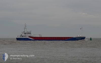
ALDEBARAN
General Cargo
Current Trip
| Time Travelled | 1 day |
|---|---|
| Remaining Time | --- |
| Distance Travelled | 263.67 nm |
| Remaining Distance | --- |
| AVG Speed | 8.8 Noeuds |
| MAX Speed | 10.4 Noeuds |
| AVG Wind | 11.1 knots |
| MAX Wind | 17 knots |
| MIN Temp | 1.4°C / 34.52°F |
| MAX Temp | 8.4°C / 47.12°F |
| Tirant d eau | 4.6 m |
| Position reçue | 12 h, 27 m depuis |
Current Position
| Longitude | --- |
|---|---|
| Latitude | --- |
| Etat | Under way using engine |
| Vitesse | 9 Noeuds |
| Parcours | 187.8° |
| Zone | North Sea |
| Station | T-AIS |
| Position reçue | 12 h, 27 m depuis |
Info
Information
The current position of ALDEBARAN is in North Sea with coordinates 56.02519° / 3.83064° as reported on 2024-12-28 20:14 by AIS to our vessel tracker app. The vessel's current speed is 9 Noeuds and is heading at the port of ISKENDERUN. The estimated time of arrival as calculated by MyShipTracking vessel tracking app is 2025-01-16 08:00 LT
The vessel ALDEBARAN (IMO: 9238387, MMSI: 275523000) is a General Cargo that was built in 2001 ( 23 Age ). It's sailing under the flag of [LV] Latvia.
In this page you can find informations about the vessels current position, last detected port calls, and current voyage information. If the vessels is not in coverage by AIS you will find the latest position.
The current position of ALDEBARAN is detected by our AIS receivers and we are not responsible for the reliability of the data. The last position was recorded while the vessel was in Coverage by the Ais receivers of our vessel tracking app.
The current draught of ALDEBARAN as reported by AIS is 4.6 meters
Weather
| Temperature | 8°C / 46.4°F |
|---|---|
| Wind Speed | 17 knots |
| Direction | 261° W |
| Pressure | 1023.7 hPa |
| Humidity | 94.7 % |
| Cloud Coverage | 21 % |
Featured Company
Last Port Calls
| Port | Arrival | Departure | Time In Port |
|---|---|---|---|
| 2024-12-26 14:58 | 2024-12-27 17:29 | 1 d | |
| 2024-12-17 08:10 | 2024-12-18 18:25 | 1 d | |
| 2024-12-06 04:44 | 2024-12-09 18:32 | 3 d | |
| 2024-12-04 19:14 | 2024-12-05 00:19 | 5 h | |
| 2024-11-16 15:46 | 2024-11-27 12:55 | 10 d | |
| 2024-11-07 21:37 | 2024-11-13 02:02 | 5 d | |
| 2024-11-04 23:11 | 2024-11-06 07:29 | 1 d | |
| 2024-11-04 21:44 | 2024-11-04 21:47 | 2 m | |
| 2024-10-25 15:46 | 2024-10-26 09:38 | 17 h | |
| 2024-10-19 08:42 | 2024-10-22 11:48 | 3 d |
Most Visited Ports (Last year)
| Port | Arrivals | |
|---|---|---|
| 2 | ||
| 2 | ||
| 2 | ||
| 2 | ||
| 2 | ||
| 2 |
Last Trips
| Origin | Departure | Destination | Arrival | Distance | |
|---|---|---|---|---|---|
| 2024-12-18 19:25 | 2024-12-26 15:58 | 667.39 nm | |||
| 2024-12-09 21:32 | 2024-12-17 09:10 | 1183.31 nm | |||
| 2024-12-05 02:19 | 2024-12-06 07:44 | 188.30 nm | |||
| 2024-11-27 13:55 | 2024-12-04 21:14 | 620.35 nm | |||
| 2024-11-13 03:02 | 2024-11-16 16:46 | 731.21 nm | |||
| 2024-11-06 08:29 | 2024-11-07 22:37 | 336.80 nm | |||
| 2024-11-04 22:47 | 2024-11-05 00:11 | 2.30 nm | |||
| 2024-11-04 22:47 | 2024-11-04 22:44 | 2.11 nm | |||
| 2024-10-22 12:48 | 2024-10-25 17:46 | 617.17 nm | |||
| 2024-10-17 16:10 | 2024-10-19 09:42 | 292.46 nm |
Events
| Heure | Evenement | Détails | Position/ Destination | Info |
|---|---|---|---|---|
| 2024-12-28 21:08 | Etat Changé | Default Under way using engine |
55.89295 / 3.79383
TRISK
|
Vitesse: 9 kn Parcours: 187.8° |
| 2024-12-28 20:14 | Hors de la zone couverte |
56.02519 / 3.83064
North Sea
TRISK
|
Vitesse: 9 kn Parcours: 187.8° |
|
| 2024-12-28 19:56 | Etat Changé | Under way using engine Default |
56.07063 / 3.84254
TRISK
|
Vitesse: 8.9 kn Parcours: 187° |
| 2024-12-28 19:46 | Etat Changé | Default Under way using engine |
56.09472 / 3.84894
TRISK
|
Vitesse: 8.8 kn Parcours: 189° |
| 2024-12-28 18:31 | Detecté en mer | Danish part of the North Sea |
56.27150 / 3.91258
North Sea
TRISK
|
Vitesse: 8.7 kn Parcours: 202° |
| 2024-12-28 18:05 | Etat Changé | Under way using engine Default |
56.32928 / 3.95580
TRISK
|
Vitesse: 8.7 kn Parcours: 203° |
| 2024-12-28 17:52 | Etat Changé | Default Under way using engine |
56.35904 / 3.97808
TRISK
|
Vitesse: 8.7 kn Parcours: 199° |
| 2024-12-28 17:24 | Etat Changé | Under way using engine Default |
56.42092 / 4.01824
TRISK
|
Vitesse: 8.7 kn Parcours: 201° |
| 2024-12-28 17:17 | Etat Changé | Default Under way using engine |
56.43837 / 4.02960
TRISK
|
Vitesse: 8.7 kn Parcours: 201° |
| 2024-12-28 16:45 | Tirant d'eau modifié | 4.6 4.8 |
56.51398 / 4.07975
TRISK
|
Vitesse: 8.7 kn Parcours: 200.7° |