
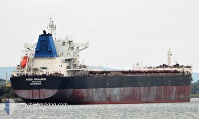
AGIOS MAKARIOS
Cargo
Current Trip
CN SON
| Time Travelled | 8 days |
|---|---|
| Remaining Time | --- |
| Distance Travelled | 1691.38 nm |
| Remaining Distance | --- |
| AVG Speed | 12.2 Noeuds |
| MAX Speed | 15 Noeuds |
| AVG Wind | 8.1 knots |
| MAX Wind | 18.3 knots |
| MIN Temp | 19.4°C / 66.92°F |
| MAX Temp | 30.7°C / 87.26°F |
| Tirant d eau | 12.2 m |
| Position reçue | 8 d depuis |
Current Position
| Longitude | 119.85209° |
|---|---|
| Latitude | 22.55750° |
| Etat | Under way using engine |
| Vitesse | 11.8 Noeuds |
| Parcours | 181.4° |
| Zone | South China Sea |
| Station | T-AIS |
| Position reçue | 8 d depuis |
Info
Information
The current position of AGIOS MAKARIOS is in South China Sea with coordinates 22.55750° / 119.85209° as reported on 2024-05-04 19:51 by AIS to our vessel tracker app. The vessel's current speed is 11.8 Noeuds
The vessel AGIOS MAKARIOS (IMO: 9474709, MMSI: 215849000) is a Cargo It's sailing under the flag of [MT] Malta.
In this page you can find informations about the vessels current position, last detected port calls, and current voyage information. If the vessels is not in coverage by AIS you will find the latest position.
The current position of AGIOS MAKARIOS is detected by our AIS receivers and we are not responsible for the reliability of the data. The last position was recorded while the vessel was in Coverage by the Ais receivers of our vessel tracking app.
The current draught of AGIOS MAKARIOS as reported by AIS is 12.2 meters
Weather
| Temperature | 27.7°C / 81.86°F |
|---|---|
| Wind Speed | 4 knots |
| Direction | 239° WSW |
| Pressure | 1010.3 hPa |
| Humidity | 81.4 % |
| Cloud Coverage | 14 % |
Featured Company
Most Visited Ports (Last year)
| Port | Arrivals | |
|---|---|---|
| 2 | ||
| 2 | ||
| 1 | ||
| 1 | ||
| 1 | ||
| 1 |
Events
| Heure | Evenement | Détails | Position/ Destination | Info |
|---|---|---|---|---|
| 2024-05-09 16:55 | Arret |
-.28054 / 117.68610
CN SON
|
Vitesse: Parcours: 115° |
|
| 2024-05-04 19:54 | Etat Changé | Default Under way using engine |
22.54925 / 119.85191
CN SON
|
Vitesse: 11.8 kn Parcours: 181.4° |
| 2024-05-04 19:51 | Hors de la zone couverte |
22.55750 / 119.85209
South China Sea
|
Vitesse: 11.8 kn Parcours: 181.4° |
|
| 2024-05-04 19:46 | Changement de zone | Taiwanese part of the South China Sea Chinese part of the South China Sea |
22.57499 / 119.85259
South China Sea
|
Vitesse: 11.7 kn Parcours: 184.9° |
| 2024-05-04 19:45 | Etat Changé | Under way using engine Default |
22.57717 / 119.85277
CN SON
|
Vitesse: 11.6 kn Parcours: 184° |
| 2024-05-04 19:45 | Dans la zone couverte |
22.57499 / 119.85259
South China Sea
|
Vitesse: 11.7 kn Parcours: 184.9° |
|
| 2024-05-04 02:49 | Démarrage | 0.76 nm, South of SONGXIA |
25.73604 / 119.63829
CN SON
|
Vitesse: 12 kn Parcours: 98° |
| 2024-05-04 02:48 | PORT DE DEPART |
|
25.73604 / 119.63829
CN SON
|
Vitesse: 0.3 kn Parcours: 208° |