
ADAM-A
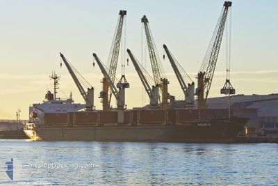
Bulk Carrier
Current Trip
| Time Travelled | 10 days |
|---|---|
| Remaining Time | --- |
| Distance Travelled | 2127.76 nm |
| Remaining Distance | --- |
| AVG Speed | 9.3 Noeuds |
| MAX Speed | 12.4 Noeuds |
| AVG Wind | 10.9 knots |
| MAX Wind | 20 knots |
| MIN Temp | 25.5°C / 77.9°F |
| MAX Temp | 32.7°C / 90.86°F |
| Tirant d eau | 5.4 m |
| Position reçue | 5 m depuis |
Current Position
| Longitude | --- |
|---|---|
| Latitude | --- |
| Etat | At anchor |
| Vitesse | 0.2 Noeuds |
| Parcours | 288° |
| Zone | Persian Gulf |
| Station | T-AIS |
| Position reçue | 5 m depuis |
Info
Information
The current position of ADAM-A is in Persian Gulf with coordinates 25.16941° / 54.82991° as reported on 2024-10-05 20:12 by AIS to our vessel tracker app. The vessel's current speed is 0.2 Noeuds
The vessel ADAM-A (IMO: 9114543, MMSI: 511100696) is a Bulk Carrier that was built in 1995 ( 29 Age ). It's sailing under the flag of [PW] Palau.
In this page you can find informations about the vessels current position, last detected port calls, and current voyage information. If the vessels is not in coverage by AIS you will find the latest position.
The current position of ADAM-A is detected by our AIS receivers and we are not responsible for the reliability of the data. The last position was recorded while the vessel was in Coverage by the Ais receivers of our vessel tracking app.
The current draught of ADAM-A as reported by AIS is 5.4 meters
Weather
| Temperature | 31.3°C / 88.34°F |
|---|---|
| Wind Speed | 7 knots |
| Direction | 271° W |
| Pressure | 1006.5 hPa |
| Humidity | 54.5 % |
| Cloud Coverage | --- |
Featured Company
Last Port Calls
| Port | Arrival | Departure | Time In Port |
|---|---|---|---|
| 2024-09-22 13:46 | 2024-09-25 12:36 | 2 d | |
| 2024-09-16 20:45 | 2024-09-17 11:56 | 15 h | |
| 2024-09-07 05:05 | 2024-09-07 15:12 | 10 h | |
| 2024-08-06 12:57 | 2024-08-09 17:09 | 3 d | |
| 2024-08-03 23:33 | 2024-08-05 12:35 | 1 d |
Most Visited Ports (Last year)
| Port | Arrivals | |
|---|---|---|
| 4 | ||
| 2 | ||
| 2 | ||
| 2 | ||
| 1 | ||
| 1 |
Last Trips
| Origin | Departure | Destination | Arrival | Distance | |
|---|---|---|---|---|---|
| 2024-09-17 14:56 | 2024-09-22 16:46 | 291.10 nm | |||
| 2024-08-09 18:09 | 2024-09-16 23:45 | 7095.50 nm | |||
| 2024-08-09 18:09 | 2024-09-07 07:05 | 5655.34 nm | |||
| 2024-08-05 13:35 | 2024-08-06 13:57 | 9.87 nm | |||
| 2024-07-11 18:02 | 2024-08-04 00:33 | 2463.02 nm |
Events
| Heure | Evenement | Détails | Position/ Destination | Info |
|---|---|---|---|---|
| 2024-10-05 20:12 | Etat Changé | At anchor Default |
25.16941 / 54.82991
JEBEL ALI
|
Vitesse: Parcours: 300° |
| 2024-10-05 19:45 | Etat Changé | Default At anchor |
25.16945 / 54.82989
JEBEL ALI
|
Vitesse: Parcours: 284° |
| 2024-10-05 19:27 | Etat Changé | At anchor Default |
25.16913 / 54.82963
JEBEL ALI
|
Vitesse: 0.3 kn Parcours: 276° |
| 2024-10-05 19:06 | Etat Changé | Default At anchor |
25.16942 / 54.82977
JEBEL ALI
|
Vitesse: 0.2 kn Parcours: 280° |
| 2024-10-05 18:56 | Etat Changé | At anchor Default |
25.16966 / 54.82984
JEBEL ALI
|
Vitesse: 0.1 kn Parcours: 291° |
| 2024-10-05 18:42 | Etat Changé | Default At anchor |
25.17002 / 54.82980
JEBEL ALI
|
Vitesse: 0.1 kn Parcours: 262° |
| 2024-10-05 18:35 | Etat Changé | At anchor Default |
25.16994 / 54.82984
JEBEL ALI
|
Vitesse: 0.6 kn Parcours: 301° |
| 2024-10-05 18:06 | Etat Changé | Default At anchor |
25.16971 / 54.82967
JEBEL ALI
|
Vitesse: 0.1 kn Parcours: 285° |
| 2024-10-05 17:38 | Etat Changé | At anchor Default |
25.16964 / 54.82994
JEBEL ALI
|
Vitesse: 0.3 kn Parcours: 270° |
| 2024-10-05 17:12 | Etat Changé | Default At anchor |
25.17002 / 54.82985
JEBEL ALI
|
Vitesse: 0.4 kn Parcours: 281° |