
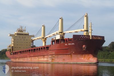
AAL GEELONG
General Cargo
Current Trip
| Time Travelled | 1 day |
|---|---|
| Remaining Time | 3 days |
| Distance Travelled | 427.51 nm |
| Remaining Distance | 906.74 nm |
| AVG Speed | 12.5 Noeuds |
| MAX Speed | 16.4 Noeuds |
| AVG Wind | 13.1 knots |
| MAX Wind | 27 knots |
| MIN Temp | 1.6°C / 34.88°F |
| MAX Temp | 11.1°C / 51.98°F |
| Tirant d eau | 7.5 m |
| Position reçue | 10 h, 48 m depuis |
Current Position
| Longitude | --- |
|---|---|
| Latitude | --- |
| Etat | Under way using engine |
| Vitesse | 11.1 Noeuds |
| Parcours | 241.1° |
| Zone | English Channel |
| Station | T-AIS |
| Position reçue | 10 h, 48 m depuis |
Info
Information
The current position of AAL GEELONG is in English Channel with coordinates 49.74885° / -3.43572° as reported on 2024-11-22 12:00 by AIS to our vessel tracker app. The vessel's current speed is 11.1 Noeuds and is heading at the port of HUELVA. The estimated time of arrival as calculated by MyShipTracking vessel tracking app is 2024-11-26 06:25 LT
The vessel AAL GEELONG (IMO: 9393539, MMSI: 210998000) is a General Cargo that was built in 2009 ( 15 Age ). It's sailing under the flag of [CY] Cyprus.
In this page you can find informations about the vessels current position, last detected port calls, and current voyage information. If the vessels is not in coverage by AIS you will find the latest position.
The current position of AAL GEELONG is detected by our AIS receivers and we are not responsible for the reliability of the data. The last position was recorded while the vessel was in Coverage by the Ais receivers of our vessel tracking app.
The current draught of AAL GEELONG as reported by AIS is 7.5 meters
Weather
| Temperature | 12.4°C / 54.32°F |
|---|---|
| Wind Speed | 22 knots |
| Direction | 190° S |
| Pressure | 1013 hPa |
| Humidity | 59.5 % |
| Cloud Coverage | 100 % |
Featured Company
Last Port Calls
| Port | Arrival | Departure | Time In Port |
|---|---|---|---|
| 2024-11-18 23:39 | 2024-11-21 08:40 | 2 d | |
| 2024-11-15 05:25 | 2024-11-17 16:30 | 2 d | |
| 2024-11-07 08:08 | 2024-11-11 18:29 | 4 d | |
| 2024-10-17 07:04 | 2024-10-18 06:52 | 23 h | |
| 2024-09-26 02:37 | 2024-09-30 08:09 | 4 d | |
| 2024-09-04 06:28 | 2024-09-06 08:44 | 2 d |
Most Visited Ports (Last year)
| Port | Arrivals | |
|---|---|---|
| 3 | ||
| 2 | ||
| 2 | ||
| 1 | ||
| 1 | ||
| 1 |
Last Trips
| Origin | Departure | Destination | Arrival | Distance | |
|---|---|---|---|---|---|
| 2024-11-17 17:30 | 2024-11-19 00:39 | 297.20 nm | |||
| 2024-11-11 19:29 | 2024-11-15 06:25 | 951.55 nm | |||
| 2024-10-18 08:52 | 2024-11-07 09:08 | 6131.64 nm | |||
| 2024-09-30 13:39 | 2024-10-17 09:04 | 4585.73 nm | |||
| 2024-09-06 16:44 | 2024-09-26 08:07 | 4089.97 nm | |||
| 2024-08-30 07:08 | 2024-09-04 14:28 | 1373.21 nm |
Events
| Heure | Evenement | Détails | Position/ Destination | Info |
|---|---|---|---|---|
| 2024-11-22 12:06 | Etat Changé | Default Under way using engine |
49.74021 / -3.46062
HUELVA
|
Vitesse: 11.1 kn Parcours: 241.1° |
| 2024-11-22 12:00 | Etat Changé | Under way using engine Default |
49.74885 / -3.43572
HUELVA
|
Vitesse: 11.3 kn Parcours: 241° |
| 2024-11-22 12:00 | Hors de la zone couverte |
49.74885 / -3.43572
English Channel
|
Vitesse: 11.1 kn Parcours: 241.1° |
|
| 2024-11-22 11:50 | Dans la zone couverte |
49.74885 / -3.43572
English Channel
|
Vitesse: 11.1 kn Parcours: 241.1° |
|
| 2024-11-22 02:38 | Etat Changé | Default Under way using engine |
50.35584 / -.87941
HUELVA
|
Vitesse: 10.7 kn Parcours: 257.8° |
| 2024-11-22 02:32 | Etat Changé | Under way using engine Default |
50.35982 / -.85182
HUELVA
|
Vitesse: 10.6 kn Parcours: 257° |
| 2024-11-22 02:32 | Hors de la zone couverte |
50.35982 / -.85182
English Channel
|
Vitesse: 10.7 kn Parcours: 257.8° |
|
| 2024-11-22 02:26 | Etat Changé | Default Under way using engine |
50.36348 / -.82586
HUELVA
|
Vitesse: 10.2 kn Parcours: 257.4° |
| 2024-11-22 01:47 | Etat Changé | Under way using engine Default |
50.38876 / -.65489
HUELVA
|
Vitesse: 10.4 kn Parcours: 256° |
| 2024-11-22 01:30 | Etat Changé | Default Under way using engine |
50.39932 / -.58390
HUELVA
|
Vitesse: 10.3 kn Parcours: 257.6° |