
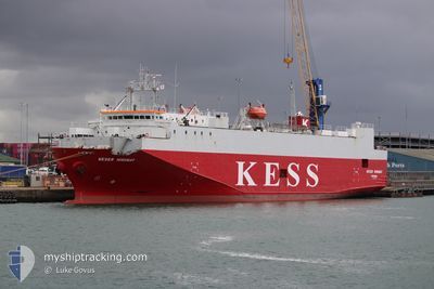
WESER HIGHWAY
Vehicles Carrier
Current Trip
| Trip Time | 1 day |
|---|---|
| Trip Distance | 425.85 nm |
| AVG Speed | 11.7 Noeuds |
| MAX Speed | 14.7 Noeuds |
| Tirant d eau | 4.6 m |
| AVG Wind | 17.8 knots |
| MAX Wind | 30.1 knots |
| MIN Temp | -9.7°C / 14.54°F |
| MAX Temp | -0.2°C / 31.64°F |
| Position reçue | 7 m depuis |
Current Position
| Longitude | --- |
|---|---|
| Latitude | --- |
| Etat | Moored |
| Vitesse | |
| Parcours | 352° |
| Zone | Baltic Sea |
| Station | T-AIS |
| Position reçue | 7 m depuis |
Info
Information
The current position of WESER HIGHWAY is in Baltic Sea with coordinates 54.14589° / 12.10462° as reported on 2026-02-04 03:45 by AIS to our vessel tracker app. The vessel's current speed is 0 Noeuds and is currently inside the port of ROSTOCK.
The vessel WESER HIGHWAY (IMO: 9065417, MMSI: 355390000) is a Vehicles Carrier that was built in 1994 ( 32 Age ). It's sailing under the flag of [PA] Panama.
In this page you can find informations about the vessels current position, last detected port calls, and current voyage information. If the vessels is not in coverage by AIS you will find the latest position.
The current position of WESER HIGHWAY is detected by our AIS receivers and we are not responsible for the reliability of the data. The last position was recorded while the vessel was in Coverage by the Ais receivers of our vessel tracking app.
The current draught of WESER HIGHWAY as reported by AIS is 4.6 meters
Weather
| Temperature | -6.3°C / 20.66°F |
|---|---|
| Wind Speed | 21 knots |
| Direction | 100° E |
| Pressure | 1010.9 hPa |
| Humidity | 76.8 % |
| Cloud Coverage | 13 % |
Featured Company
Last Port Calls
| Port | Arrival | Departure | Time In Port |
|---|---|---|---|
| 2026-02-04 03:11 | |||
| 2026-02-02 13:10 | 2026-02-02 18:04 | 4 h | |
| 2026-01-31 04:11 | 2026-01-31 16:45 | 12 h | |
| 2026-01-28 11:13 | 2026-01-29 13:39 | 1 d | |
| 2026-01-26 02:11 | 2026-01-26 15:52 | 13 h | |
| 2026-01-23 00:36 | 2026-01-24 14:54 | 1 d | |
| 2026-01-21 03:54 | 2026-01-21 14:56 | 11 h | |
| 2026-01-17 20:35 | 2026-01-19 17:56 | 1 d | |
| 2026-01-16 04:10 | 2026-01-16 13:46 | 9 h | |
| 2026-01-13 11:12 | 2026-01-13 11:40 | 27 m |
Last Trips
| Origin | Departure | Destination | Arrival | Distance | |
|---|---|---|---|---|---|
| 2026-02-02 18:04 | 2026-02-04 03:11 | 425.85 nm | |||
| 2026-01-31 16:45 | 2026-02-02 13:10 | 430.35 nm | |||
| 2026-01-29 13:39 | 2026-01-31 04:11 | 425.17 nm | |||
| 2026-01-26 15:52 | 2026-01-28 11:13 | 444.31 nm | |||
| 2026-01-24 14:54 | 2026-01-26 02:11 | 398.63 nm | |||
| 2026-01-21 14:56 | 2026-01-23 00:36 | 420.31 nm | |||
| 2026-01-19 17:56 | 2026-01-21 03:54 | 398.54 nm | |||
| 2026-01-16 13:46 | 2026-01-17 20:35 | 396.89 nm | |||
| 2026-01-13 11:40 | 2026-01-16 04:10 | 704.33 nm | |||
| 2026-01-13 00:09 | 2026-01-13 11:12 | 0.82 nm |
Events
| Heure | Evenement | Détails | Position/ Destination | Info |
|---|---|---|---|---|
| 2026-02-04 02:54 | Etat Changé | Moored Under way using engine |
54.14592 / 12.10456
[DE] ROSTOCK
|
Vitesse: 0.1 kn Parcours: 350° |
| 2026-02-04 02:42 | Arret |
54.14597 / 12.10387
[DE] ROSTOCK
|
Vitesse: 0.3 kn Parcours: 131° |
|
| 2026-02-04 02:11 | Port d'arrivée |
|
54.18829 / 12.08881
[DE] ROSTOCK
|
Vitesse: 8.8 kn Parcours: 162.3° |
| 2026-02-04 00:40 | Changement de zone | German part of the Baltic Sea Danish part of the Baltic Sea |
54.36237 / 11.83884
Baltic Sea
DERSK
|
Vitesse: 9.2 kn Parcours: 129° |
| 2026-02-03 20:13 | Changement de zone | Danish part of the Baltic Sea German part of the Baltic Sea |
54.84092 / 12.93622
Baltic Sea
DERSK
|
Vitesse: 13 kn Parcours: 255° |
| 2026-02-03 18:06 | Etat Changé | Under way using engine Default |
55.00101 / 13.70754
DERSK
|
Vitesse: 13.4 kn Parcours: 248° |
| 2026-02-03 18:05 | Etat Changé | Default Under way using engine |
55.00238 / 13.71375
DERSK
|
Vitesse: 13.5 kn Parcours: 248.2° |
| 2026-02-03 17:55 | Changement de zone | German part of the Baltic Sea Swedish part of the Baltic Sea |
55.01527 / 13.77562
Baltic Sea
DERSK
|
Vitesse: 13.2 kn Parcours: 251.4° |
| 2026-02-03 14:48 | Changement de zone | Swedish part of the Baltic Sea Danish part of the Kattegat |
55.44512 / 14.66072
Baltic Sea
DERSK
|
Vitesse: 12 kn Parcours: 247.7° |
| 2026-02-03 12:13 | Detecté en mer | Danish part of the Kattegat |
55.56523 / 15.57269
Kattegat
DERSK
|
Vitesse: 12.5 kn Parcours: 256.3° |