
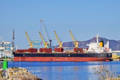
LAGONDA
Bulk Carrier
Current Trip
| Trip Time | 7 days |
|---|---|
| Trip Distance | 1700.03 nm |
| AVG Speed | 12.3 Knoten |
| MAX Speed | 15.7 Knoten |
| Tiefgang | 10.4 m |
| AVG Wind | 10.3 knots |
| MAX Wind | 20.9 knots |
| MIN Temp | 23.9°C / 75.02°F |
| MAX Temp | 30.2°C / 86.36°F |
| Position erhalten | 11 m alt |
Current Position
| Länge | -38.47420° |
|---|---|
| Breite | -3.70903° |
| Zustand | Moored |
| Geschwindigkeit | |
| Kurs | 199° |
| Gebiet | South Atlantic Ocean |
| Station | T-AIS |
| Position erhalten | 11 m alt |
Info
Information
Die aktuelle Position von LAGONDA befindet sich in South Atlantic Ocean mit den Koordinaten -3.70903° / -38.47420°, wie von AIS am 2024-05-14 13:24 an unsere Schiffsverfolgungs-App. Die aktuelle Geschwindigkeit des Schiffes betragt 0 Knoten und befindet sich derzeit im Port von FORTALEZA .
Das Schiff LAGONDA (IMO: 9456549, MMSI: 538004260) ist Bulk Carrier das wurde im Jahr 2011 ( 13 Jahre alt ) gebaut. Es segelt unter der Flagge [MH] Marshall Is.
Auf dieser Seite finden Sie Informationen zur aktuellen Position des Schiffes, zu den zuletzt erkannten Hafenanlaufen und zu aktuellen Reiseinformationen. Wenn die Schiffe nicht von AIS abgedeckt werden, finden Sie die neueste Position.
Die aktuelle Position von LAGONDA wird von unseren AIS-Empfangern erkannt und wir sind nicht fur die Zuverlassigkeit der Daten verantwortlich. Die letzte Position wurde von den Ais-Empfangern unserer Schiffsverfolgungs-App aufgezeichnet, wahrend sich das Schiff in Deckung befand.
Der aktuelle Entwurf von LAGONDA, wie von AIS gemeldet, betragt 10.4 meter
Weather
| Temperature | 27.7°C / 81.86°F |
|---|---|
| Wind Speed | 8 knots |
| Direction | 139° SE |
| Pressure | 1012.9 hPa |
| Humidity | 84.2 % |
| Cloud Coverage | 100 % |
Featured Company
Last Trips
Events
| Zeit | Ereignis | Details | Position / Ziel | Information |
|---|---|---|---|---|
| 2024-05-14 13:27 | geänderter Status | Default Moored |
-3.70900 / -38.47420
[BR] FORTALEZA
|
Geschwindigkeit: Kurs: 199° |
| 2024-05-14 13:18 | geänderter Status | Moored Default |
-3.70902 / -38.47420
[BR] FORTALEZA
|
Geschwindigkeit: Kurs: 199° |
| 2024-05-14 13:12 | geänderter Status | Default Moored |
-3.70902 / -38.47420
[BR] FORTALEZA
|
Geschwindigkeit: Kurs: 199° |
| 2024-05-14 12:48 | geänderter Status | Moored Default |
-3.70903 / -38.47422
[BR] FORTALEZA
|
Geschwindigkeit: Kurs: 199° |
| 2024-05-14 12:39 | geänderter Status | Default Moored |
-3.70902 / -38.47423
[BR] FORTALEZA
|
Geschwindigkeit: Kurs: 199° |
| 2024-05-14 12:36 | geänderter Status | Moored Default |
-3.70900 / -38.47420
[BR] FORTALEZA
|
Geschwindigkeit: Kurs: 199° |
| 2024-05-14 12:33 | geänderter Status | Default Moored |
-3.70900 / -38.47422
[BR] FORTALEZA
|
Geschwindigkeit: Kurs: 199° |
| 2024-05-14 12:24 | geänderter Status | Moored Default |
-3.70898 / -38.47420
[BR] FORTALEZA
|
Geschwindigkeit: Kurs: 199° |
| 2024-05-14 12:15 | geänderter Status | Default Moored |
-3.70900 / -38.47420
[BR] FORTALEZA
|
Geschwindigkeit: Kurs: 199° |
| 2024-05-14 12:12 | geänderter Status | Moored Default |
-3.70900 / -38.47422
[BR] FORTALEZA
|
Geschwindigkeit: Kurs: 199° |