
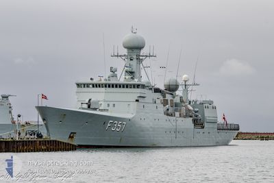
HDMS THETIS
Military ops
Current Trip
MILITARY OPS
| Time Travelled | 3 days |
|---|---|
| Remaining Time | --- |
| Distance Travelled | 1025.47 nm |
| Remaining Distance | --- |
| AVG Speed | 10.3 Knoten |
| MAX Speed | 17.4 Knoten |
| AVG Wind | 13.8 knots |
| MAX Wind | 23.7 knots |
| MIN Temp | 1.8°C / 35.24°F |
| MAX Temp | 8.3°C / 46.94°F |
| Tiefgang | 6.6 m |
| Position erhalten | 1 m alt |
Current Position
| Länge | 11.14562° |
|---|---|
| Breite | 57.46188° |
| Zustand | Under way using engine |
| Geschwindigkeit | 11.1 Knoten |
| Kurs | 89.3° |
| Gebiet | Kattegat |
| Station | T-AIS |
| Position erhalten | 1 m alt |
Info
Information
Die aktuelle Position von HDMS THETIS befindet sich in Kattegat mit den Koordinaten 57.46188° / 11.14562°, wie von AIS am 2024-04-26 08:57 an unsere Schiffsverfolgungs-App. Die aktuelle Geschwindigkeit des Schiffes betragt 11.1 Knoten
Das Schiff HDMS THETIS (MMSI: 219522000) ist Military ops Es segelt unter der Flagge [DK] Denmark.
Auf dieser Seite finden Sie Informationen zur aktuellen Position des Schiffes, zu den zuletzt erkannten Hafenanlaufen und zu aktuellen Reiseinformationen. Wenn die Schiffe nicht von AIS abgedeckt werden, finden Sie die neueste Position.
Die aktuelle Position von HDMS THETIS wird von unseren AIS-Empfangern erkannt und wir sind nicht fur die Zuverlassigkeit der Daten verantwortlich. Die letzte Position wurde von den Ais-Empfangern unserer Schiffsverfolgungs-App aufgezeichnet, wahrend sich das Schiff in Deckung befand.
Der aktuelle Entwurf von HDMS THETIS, wie von AIS gemeldet, betragt 6.6 meter
Weather
| Temperature | 5.3°C / 41.54°F |
|---|---|
| Wind Speed | 14 knots |
| Direction | 115° ESE |
| Pressure | 1007.8 hPa |
| Humidity | 71.8 % |
| Cloud Coverage | 97 % |
Featured Company
Last Port Calls
| Port | Arrival | Departure | Time In Port |
|---|---|---|---|
| 2024-04-22 06:14 | 2024-04-22 14:03 | 7 h | |
| 2024-04-19 07:15 | 2024-04-19 12:06 | 4 h | |
| 2024-04-19 06:21 | 2024-04-19 06:59 | 38 m | |
| 2024-04-12 13:48 | 2024-04-15 09:13 | 2 d | |
| 2024-03-18 08:41 | |||
| 2024-03-17 12:17 | 2024-03-17 14:04 | 1 h | |
| 2024-03-16 12:33 | 2024-03-17 09:50 | 21 h | |
| 2024-03-15 15:00 | 2024-03-16 10:03 | 19 h | |
| 2024-03-13 19:47 | 2024-03-14 07:19 | 11 h | |
| 2024-03-08 17:22 | 2024-03-11 09:42 | 2 d |
Most Visited Ports (Last year)
| Port | Arrivals | |
|---|---|---|
| 24 | ||
| 13 | ||
| 6 | ||
| 4 | ||
| 3 | ||
| 2 |
Last Trips
| Origin | Departure | Destination | Arrival | Distance | |
|---|---|---|---|---|---|
| 2024-04-19 14:06 | 2024-04-22 08:14 | 397.87 nm | |||
| 2024-04-19 08:59 | 2024-04-19 09:15 | 1.85 nm | |||
| 2024-04-15 11:13 | 2024-04-19 08:21 | 679.82 nm | |||
| 2024-03-17 15:04 | 2024-04-12 15:48 | 353.44 nm | |||
| 2024-03-17 15:04 | 2024-03-18 09:41 | 196.33 nm | |||
| 2024-03-17 10:50 | 2024-03-17 13:17 | 27.71 nm | |||
| 2024-03-16 11:03 | 2024-03-16 13:33 | 24.45 nm | |||
| 2024-03-14 08:19 | 2024-03-15 16:00 | 334.05 nm | |||
| 2024-03-11 10:42 | 2024-03-13 20:47 | 539.90 nm | |||
| 2024-03-08 11:06 | 2024-03-08 18:22 | 110.19 nm |
Events
| Zeit | Ereignis | Details | Position / Ziel | Information |
|---|---|---|---|---|
| 2024-04-25 05:20 | Ändere Seegebiet | Danish part of the Kattegat Danish part of the Baltic Sea |
54.75244 / 10.88249
Kattegat
|
Geschwindigkeit: 14.3 kn Kurs: 357.4° |
| 2024-04-24 21:44 | Ändere Seegebiet | Danish part of the Baltic Sea Danish part of the Kattegat |
55.29261 / 12.51468
Baltic Sea
|
Geschwindigkeit: 13.4 kn Kurs: 194.5° |
| 2024-04-24 11:41 | START Bewegung | 3.93 nm, North East of SJAELLANDS ODDE |
56.01089 / 11.39422
MILITARY OPS
|
Geschwindigkeit: 7.6 kn Kurs: 116° |
| 2024-04-24 11:29 | STOP Bewegung | 3.82 nm, North East of SJAELLANDS ODDE |
56.01017 / 11.39120
MILITARY OPS
|
Geschwindigkeit: 0.3 kn Kurs: 89° |
| 2024-04-24 11:12 | START Bewegung | 5.35 nm, North East of SJAELLANDS ODDE |
56.04570 / 11.39082
MILITARY OPS
|
Geschwindigkeit: 8.2 kn Kurs: 185.1° |
| 2024-04-24 11:09 | STOP Bewegung | 5.4 nm, North East of SJAELLANDS ODDE |
56.04736 / 11.38911
MILITARY OPS
|
Geschwindigkeit: 0.2 kn Kurs: 90° |
| 2024-04-22 17:47 | Ändere Seegebiet | Danish part of the Kattegat Swedish part of the Kattegat |
57.20467 / 11.59292
Kattegat
|
Geschwindigkeit: 11.2 kn Kurs: 162.9° |
| 2024-04-22 17:26 | Ändere Seegebiet | Swedish part of the Kattegat Danish part of the Kattegat |
57.26251 / 11.55062
Kattegat
|
Geschwindigkeit: 11.1 kn Kurs: 129.8° |
| 2024-04-22 14:03 | ABFAHRTSHAFEN |
|
57.43159 / 10.55597
MILITARY OPS
|
Geschwindigkeit: 8 kn Kurs: 134° |
| 2024-04-22 13:59 | START Bewegung |
57.43276 / 10.54553
[DK] FREDERIKSHAVN
|
Geschwindigkeit: 4.4 kn Kurs: 49° |