
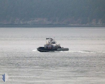
YT813 SENTINEL
Tug
Current Trip
| Time Travelled | 14 days |
|---|---|
| Remaining Time | --- |
| Distance Travelled | 47.85 nm |
| Remaining Distance | --- |
| AVG Speed | 8.6 Knots |
| MAX Speed | 12.5 Knots |
| AVG Wind | 4.4 knots |
| MAX Wind | 6 knots |
| MIN Temp | -3.3°C / 26.06°F |
| MAX Temp | 5.8°C / 42.44°F |
| Dybgang | 5 m |
| Position Modtaget | 15 h, 8 m siden |
Current Position
| Longitude | --- |
|---|---|
| Latitude | --- |
| Status | Under way using engine |
| Fart | |
| Kurs | 270° |
| Område | The Coastal Waters of Southeast Alaska and British Columbia |
| Station | T-AIS |
| Position Modtaget | 15 h, 8 m siden |
Info
Information
The current position of YT813 SENTINEL is in The Coastal Waters of Southeast Alaska and British Columbia with coordinates 47.55355° / -122.64902° as reported on 2025-02-17 17:18 by AIS to our vessel tracker app. The vessel's current speed is 0 Knots
The vessel YT813 SENTINEL (MMSI: 368926641) is a Tug It's sailing under the flag of [US] USA.
In this page you can find informations about the vessels current position, last detected port calls, and current voyage information. If the vessels is not in coverage by AIS you will find the latest position.
The current position of YT813 SENTINEL is detected by our AIS receivers and we are not responsible for the reliability of the data. The last position was recorded while the vessel was in Coverage by the Ais receivers of our vessel tracking app.
The current draught of YT813 SENTINEL as reported by AIS is 5 meters
Weather
| Temperature | 5.7°C / 42.26°F |
|---|---|
| Wind Speed | 2 knots |
| Direction | 190° S |
| Pressure | 1011.7 hPa |
| Humidity | 98.9 % |
| Cloud Coverage | 100 % |
Featured Company
Last Port Calls
| Port | Arrival | Departure | Time In Port |
|---|---|---|---|
| 2025-02-03 21:32 | 2025-02-03 21:43 | 10 m | |
| 2025-02-03 19:37 | 2025-02-03 21:08 | 1 h | |
| 2025-01-31 16:36 | 2025-01-31 17:23 | 46 m | |
| 2025-01-31 12:13 | 2025-01-31 14:52 | 2 h | |
| 2025-01-30 22:11 | 2025-01-30 23:49 | 1 h | |
| 2025-01-25 15:42 | 2025-01-25 16:50 | 1 h | |
| 2025-01-23 00:01 | 2025-01-23 01:10 | 1 h | |
| 2025-01-22 20:01 | 2025-01-22 23:08 | 3 h | |
| 2025-01-22 16:05 | 2025-01-22 17:24 | 1 h | |
| 2025-01-21 21:29 | 2025-01-21 22:30 | 1 h |
Most Visited Ports (Last year)
| Port | Arrivals | |
|---|---|---|
| 29 | ||
| 24 | ||
| 16 | ||
| 2 |
Last Trips
| Origin | Departure | Destination | Arrival | Distance | |
|---|---|---|---|---|---|
| 2025-02-03 13:08 | 2025-02-03 13:32 | 2.78 nm | |||
| 2025-01-31 09:23 | 2025-02-03 11:37 | 9.17 nm | |||
| 2025-01-31 06:52 | 2025-01-31 08:36 | 1.45 nm | |||
| 2025-01-30 15:49 | 2025-01-31 04:13 | 8.22 nm | |||
| 2025-01-25 08:50 | 2025-01-30 14:11 | 114.62 nm | |||
| 2025-01-22 17:10 | 2025-01-25 07:42 | 41.66 nm | |||
| 2025-01-22 15:08 | 2025-01-22 16:01 | 4.06 nm | |||
| 2025-01-22 09:24 | 2025-01-22 12:01 | 30.30 nm | |||
| 2025-01-21 14:30 | 2025-01-22 08:05 | 19.72 nm | |||
| 2025-01-20 11:13 | 2025-01-21 13:29 | 8.75 nm |
Events
| Tid | Hændelsen | Detaljer | Position / Dest | Info |
|---|---|---|---|---|
| 2025-02-17 17:18 | Udenfor Dækning |
47.55355 / -122.64902
The Coastal Waters of Southeast Alaska and British Columbia
|
Fart: Kurs: 248.1° |
|
| 2025-02-17 17:09 | STOP Sejllads | 1.07 nm, South West of BREMERTON |
47.55341 / -122.64874
BREMERTON
|
Fart: 0.3 kn Kurs: 275° |
| 2025-02-17 16:45 | ETA er ændret | 2025/02/10 20:00 |
47.55121 / -122.64183
BREMERTON
|
Fart: 2.9 kn Kurs: 261° |
| 2025-02-17 15:46 | START Sejllads | 2.23 nm, East of MANCHESTER |
47.55839 / -122.48144
BREMERTON
|
Fart: 5.3 kn Kurs: 293° |
| 2025-02-17 13:44 | STOP Sejllads | 2.24 nm, East of MANCHESTER |
47.55653 / -122.48124
BREMERTON
|
Fart: Kurs: 15° |
| 2025-02-17 13:34 | START Sejllads | 2.37 nm, North of VASHON ISLAND |
47.55145 / -122.46733
BREMERTON
|
Fart: 6.8 kn Kurs: 332.1° |
| 2025-02-17 13:21 | STOP Sejllads | 2.26 nm, North of VASHON ISLAND |
47.54957 / -122.46708
BREMERTON
|
Fart: 0.3 kn Kurs: 349° |
| 2025-02-17 13:11 | START Sejllads | 2.37 nm, South East of PORT BLAKELY |
47.56295 / -122.47082
BREMERTON
|
Fart: 3.2 kn Kurs: 352° |
| 2025-02-17 12:45 | ETA er ændret | 2025/02/10 20:00 |
47.56524 / -122.46990
BREMERTON
|
Fart: 0.1 kn Kurs: 0° |
| 2025-02-17 12:27 | ETA er ændret | 2025/02/10 20:00 |
47.56496 / -122.47001
BREMERTON
|
Fart: Kurs: 338° |