
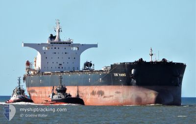
XIN HANG
Bulk Carrier
Current Trip
| Time Travelled | 7 days |
|---|---|
| Remaining Time | --- |
| Distance Travelled | 490.12 nm |
| Remaining Distance | --- |
| AVG Speed | 8.7 Knots |
| MAX Speed | 12.2 Knots |
| AVG Wind | 8.8 knots |
| MAX Wind | 14 knots |
| MIN Temp | 16.6°C / 61.88°F |
| MAX Temp | 22.4°C / 72.32°F |
| Dybgang | 18.2 m |
| Position Modtaget | 9 d siden |
Current Position
| Longitude | 119.76614° |
|---|---|
| Latitude | 35.20403° |
| Status | At anchor |
| Fart | 0.1 Knots |
| Kurs | 171° |
| Område | Yellow Sea |
| Station | T-AIS |
| Position Modtaget | 9 d siden |
Info
Information
The current position of XIN HANG is in Yellow Sea with coordinates 35.20403° / 119.76614° as reported on 2024-05-19 10:12 by AIS to our vessel tracker app. The vessel's current speed is 0.1 Knots
The vessel XIN HANG (IMO: 9469649, MMSI: 636014628) is a Bulk Carrier that was built in 2010 ( 14 år gamle ). It's sailing under the flag of [LR] Liberia.
In this page you can find informations about the vessels current position, last detected port calls, and current voyage information. If the vessels is not in coverage by AIS you will find the latest position.
The current position of XIN HANG is detected by our AIS receivers and we are not responsible for the reliability of the data. The last position was recorded while the vessel was in Coverage by the Ais receivers of our vessel tracking app.
The current draught of XIN HANG as reported by AIS is 18.2 meters
Weather
| Temperature | 19.8°C / 67.64°F |
|---|---|
| Wind Speed | 12 knots |
| Direction | 107° ESE |
| Pressure | 1011.7 hPa |
| Humidity | 72.7 % |
| Cloud Coverage | 93 % |
Featured Company
Last Port Calls
| Port | Arrival | Departure | Time In Port |
|---|---|---|---|
| 2024-05-21 09:52 | 2024-05-22 07:40 | 21 h | |
| 2024-05-14 02:52 | 2024-05-16 09:44 | 2 d | |
| 2024-03-13 07:59 | 2024-03-15 09:50 | 2 d |
Last Trips
| Origin | Departure | Destination | Arrival | Distance | |
|---|---|---|---|---|---|
| 2024-05-16 09:44 | 2024-05-21 09:52 | 571.83 nm | |||
| 2024-03-15 09:50 | 2024-05-14 02:52 | 6558.24 nm | |||
| 2024-02-26 11:58 | 2024-03-13 07:59 | 3545.35 nm |
Events
| Tid | Hændelsen | Detaljer | Position / Dest | Info |
|---|---|---|---|---|
| 2024-05-24 19:05 | STOP Sejllads | 9.48 nm, West of JINHAI HEAVY INDUSTR |
30.28647 / 122.07083
CN TAO
|
Fart: 0.3 kn Kurs: 296° |
| 2024-05-24 18:28 | START Sejllads | 9.24 nm, West of JINHAI HEAVY INDUSTR |
30.24474 / 122.07228
CN TAO
|
Fart: 3.1 kn Kurs: 330° |
| 2024-05-24 05:20 | STOP Sejllads | 9.22 nm, West of JINHAI HEAVY INDUSTR |
30.24101 / 122.07304
CN TAO
|
Fart: 0.3 kn Kurs: 359° |
| 2024-05-21 23:40 | Afsejlet fra sidste havn |
|
35.10317 / 119.42645
CN TAO
|
Fart: 5.1 kn Kurs: 127° |
| 2024-05-21 23:28 | START Sejllads |
35.11426 / 119.41784
[CN] LANSHAN
|
Fart: 3.2 kn Kurs: 219° |
|
| 2024-05-21 02:16 | STOP Sejllads |
35.11383 / 119.42090
[CN] LANSHAN
|
Fart: 0.3 kn Kurs: 341° |
|
| 2024-05-21 01:52 | Skibe i havn |
|
35.10635 / 119.42268
[CN] LANSHAN
|
Fart: 4.6 kn Kurs: 300° |
| 2024-05-20 23:01 | START Sejllads | 17.54 nm, South East of RIZHAO |
35.14702 / 119.82246
CN TAO
|
Fart: 3.1 kn Kurs: 252° |
| 2024-05-20 13:53 | STOP Sejllads | 17.41 nm, South East of RIZHAO |
35.14800 / 119.82010
CN TAO
|
Fart: Kurs: 83° |
| 2024-05-20 10:25 | START Sejllads | 13.82 nm, South East of RIZHAO |
35.19723 / 119.77274
CN TAO
|
Fart: 4.6 kn Kurs: 135° |