

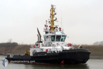
WULF 10
Tug

Current Trip
| Trip Time | 2 days |
|---|---|
| Trip Distance | 176.80 nm |
| AVG Speed | 4.7 Knots |
| MAX Speed | 8.2 Knots |
| Dybgang | 5.9 m |
| AVG Wind | 10.5 knots |
| MAX Wind | 18.9 knots |
| MIN Temp | -1.8°C / 28.76°F |
| MAX Temp | 4.4°C / 39.92°F |
| Position Modtaget | 1 m siden |
Current Position
| Longitude | --- |
|---|---|
| Latitude | --- |
| Status | Restricted manoeuverability |
| Fart | 0.1 Knots |
| Kurs | 292° |
| Område | Baltic Sea |
| Station | T-AIS |
| Position Modtaget | 1 m siden |
Information
The current position of WULF 10 is in Baltic Sea with coordinates 54.36595° / 10.14014° as reported on 2025-02-21 06:45 by AIS to our vessel tracker app. The vessel's current speed is 0.1 Knots and is currently inside the port of KIEL.
The vessel WULF 10 (IMO: 9432983, MMSI: 255915969) is a Tug that was built in 2009 ( 16 år gamle ). It's sailing under the flag of [PT] Portugal.
In this page you can find informations about the vessels current position, last detected port calls, and current voyage information. If the vessels is not in coverage by AIS you will find the latest position.
The current position of WULF 10 is detected by our AIS receivers and we are not responsible for the reliability of the data. The last position was recorded while the vessel was in Coverage by the Ais receivers of our vessel tracking app.
The current draught of WULF 10 as reported by AIS is 5.9 meters
Weather
| Temperature | 4.4°C / 39.92°F |
|---|---|
| Wind Speed | 6 knots |
| Direction | 189° S |
| Pressure | 1020.5 hPa |
| Humidity | 98.6 % |
| Cloud Coverage | 100 % |


Featured Company
Last Port Calls
| Port | Arrival | Departure | Time In Port |
|---|---|---|---|
| 2025-02-21 06:11 | |||
| 2025-02-16 19:57 | 2025-02-18 17:14 | 1 d | |
| 2025-02-13 13:40 | 2025-02-14 01:53 | 12 h | |
| 2025-02-12 14:28 | 2025-02-12 15:16 | 47 m | |
| 2025-02-12 05:43 | 2025-02-12 06:35 | 52 m | |
| 2025-02-09 14:08 | 2025-02-11 11:05 | 1 d | |
| 2025-02-07 06:28 | 2025-02-07 06:44 | 16 m | |
| 2025-02-06 12:11 | 2025-02-06 18:13 | 6 h | |
| 2025-02-06 05:20 | 2025-02-06 12:01 | 6 h | |
| 2025-02-05 06:24 | 2025-02-05 07:12 | 47 m |
Most Visited Ports (Last year)
| Port | Arrivals | |
|---|---|---|
| 10 | ||
| 4 | ||
| 3 | ||
| 3 | ||
| 2 | ||
| 1 |
Last Trips
| Origin | Departure | Destination | Arrival | Distance | |
|---|---|---|---|---|---|
| 2025-02-18 18:14 | 2025-02-21 07:11 | 176.80 nm | |||
| 2025-02-14 02:53 | 2025-02-16 20:57 | 310.92 nm | |||
| 2025-02-12 16:16 | 2025-02-13 14:40 | 99.91 nm | |||
| 2025-02-12 07:35 | 2025-02-12 15:28 | 50.98 nm | |||
| 2025-02-11 12:05 | 2025-02-12 06:43 | 175.60 nm | |||
| 2025-02-07 07:44 | 2025-02-09 15:08 | 227.15 nm | |||
| 2025-02-06 19:13 | 2025-02-07 07:28 | 86.27 nm | |||
| 2025-02-06 13:01 | 2025-02-06 13:11 | 0.42 nm | |||
| 2025-02-05 08:12 | 2025-02-06 06:20 | 147.29 nm | |||
| 2025-02-03 10:10 | 2025-02-05 07:24 | 180.24 nm |
Events
| Tid | Hændelsen | Detaljer | Position / Dest | Info |
|---|---|---|---|---|
| 2025-02-21 06:25 | STOP Sejllads |
54.36592 / 10.14032
[DE] KIEL
|
Fart: 0.2 kn Kurs: 287° |
|
| 2025-02-21 06:11 | Skibe i havn |
|
54.36368 / 10.15644
[DE] KIEL
|
Fart: 4 kn Kurs: 271° |
| 2025-02-21 05:56 | START Sejllads | 0.48 nm, South East of STICKENHΟRN SPORT |
54.37631 / 10.17552
NORDENHAM
|
Fart: 3.4 kn Kurs: 216° |
| 2025-02-21 05:50 | STOP Sejllads | 0.43 nm, South East of STICKENHΟRN SPORT |
54.37795 / 10.17693
NORDENHAM
|
Fart: 0.3 kn Kurs: 199° |
| 2025-02-21 05:37 | START Sejllads | 0.28 nm, East of STICKENHΟRN SPORT |
54.38385 / 10.17559
NORDENHAM
|
Fart: 4.4 kn Kurs: 177° |
| 2025-02-20 03:52 | STOP Sejllads | 0.29 nm, North East of STICKENHΟRN SPORT |
54.38571 / 10.17451
NORDENHAM
|
Fart: 0.3 kn Kurs: 145° |
| 2025-02-19 22:56 | Ændre havområde | German part of the Baltic Sea Danish part of the Baltic Sea |
54.56818 / 10.55291
Baltic Sea
NORDENHAM
|
Fart: 3.6 kn Kurs: 250.7° |
| 2025-02-19 20:14 | Fundet i havområde | Danish part of the Baltic Sea |
54.59525 / 10.82542
Baltic Sea
NORDENHAM
|
Fart: 3.8 kn Kurs: 263.5° |
| 2025-02-19 16:10 | Ændre havområde | German part of the Baltic Sea Danish part of the Baltic Sea |
54.55832 / 11.33915
Baltic Sea
NORDENHAM
|
Fart: 4.8 kn Kurs: 296.1° |
| 2025-02-19 07:40 | Ændre havområde | Danish part of the Baltic Sea German part of the Baltic Sea |
54.56311 / 12.29022
Baltic Sea
NORDENHAM
|
Fart: 5.9 kn Kurs: 244.1° |