
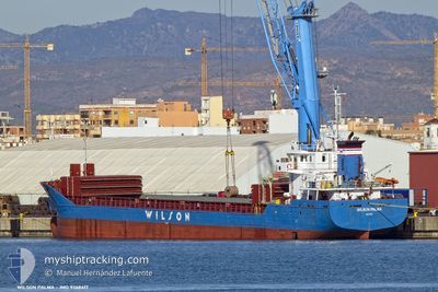
WILSON PALMA
General Cargo
Current Trip
| Time Travelled | 8 days |
|---|---|
| Remaining Time | --- |
| Distance Travelled | 241.02 nm |
| Remaining Distance | --- |
| AVG Speed | 11.3 Knots |
| MAX Speed | 12.9 Knots |
| AVG Wind | 10.3 knots |
| MAX Wind | 31.7 knots |
| MIN Temp | -15.3°C / 4.46°F |
| MAX Temp | 6.2°C / 43.16°F |
| Dybgang | 4.4 m |
| Position Modtaget | 4 m siden |
Current Position
| Longitude | --- |
|---|---|
| Latitude | --- |
| Status | Moored |
| Fart | |
| Kurs | 128° |
| Område | North Sea |
| Station | T-AIS |
| Position Modtaget | 4 m siden |
Info
Information
The current position of WILSON PALMA is in North Sea with coordinates 60.08550° / 6.53762° as reported on 2024-12-31 10:04 by AIS to our vessel tracker app. The vessel's current speed is 0 Knots
The vessel WILSON PALMA (IMO: 9368417, MMSI: 257237000) is a General Cargo that was built in 2009 ( 15 år gamle ). It's sailing under the flag of [NO] Norway.
In this page you can find informations about the vessels current position, last detected port calls, and current voyage information. If the vessels is not in coverage by AIS you will find the latest position.
The current position of WILSON PALMA is detected by our AIS receivers and we are not responsible for the reliability of the data. The last position was recorded while the vessel was in Coverage by the Ais receivers of our vessel tracking app.
The current draught of WILSON PALMA as reported by AIS is 4.4 meters
Weather
| Temperature | -12.8°C / 8.96°F |
|---|---|
| Wind Speed | 6 knots |
| Direction | 90° E |
| Pressure | 1012.8 hPa |
| Humidity | 94.3 % |
| Cloud Coverage | 100 % |
Featured Company
Last Port Calls
| Port | Arrival | Departure | Time In Port |
|---|---|---|---|
| 2024-12-21 21:11 | 2024-12-22 17:36 | 20 h | |
| 2024-12-20 12:35 | 2024-12-21 10:16 | 21 h | |
| 2024-12-19 14:23 | 2024-12-20 09:28 | 19 h | |
| 2024-12-06 02:43 | 2024-12-10 06:45 | 4 d | |
| 2024-10-28 23:03 | 2024-12-04 10:05 | ||
| 2024-10-16 10:16 | 2024-10-17 18:45 | 1 d | |
| 2024-10-11 06:23 | 2024-10-11 21:27 | 15 h | |
| 2024-10-05 12:41 | 2024-10-10 11:28 | 4 d | |
| 2024-10-02 15:04 | 2024-10-03 17:43 | 1 d | |
| 2024-10-01 19:10 |
Last Trips
| Origin | Departure | Destination | Arrival | Distance | |
|---|---|---|---|---|---|
| 2024-12-21 11:16 | 2024-12-21 22:11 | 106.13 nm | |||
| 2024-12-20 10:28 | 2024-12-20 13:35 | 34.58 nm | |||
| 2024-12-10 07:45 | 2024-12-19 15:23 | 684.75 nm | |||
| 2024-12-04 11:05 | 2024-12-06 03:43 | 79.93 nm | |||
| 2024-10-17 20:45 | 2024-10-29 00:03 | 1447.35 nm | |||
| 2024-10-11 22:27 | 2024-10-16 12:16 | 993.67 nm | |||
| 2024-10-10 12:28 | 2024-10-11 07:23 | 138.56 nm | |||
| 2024-10-03 18:43 | 2024-10-05 13:41 | 364.07 nm | |||
| 2024-10-01 20:10 | 2024-10-02 16:04 | 158.64 nm |
Events
| Tid | Hændelsen | Detaljer | Position / Dest | Info |
|---|---|---|---|---|
| 2024-12-31 06:05 | Status er ændret | Moored Under way using engine |
60.08553 / 6.53763
NOARD=>NOODD
|
Fart: Kurs: 127° |
| 2024-12-31 05:36 | Status er ændret | Under way using engine Moored |
60.08215 / 6.54290
NOARD=>NOODD
|
Fart: 0.8 kn Kurs: 128° |
| 2024-12-30 20:55 | STOP Sejllads | 1.02 nm, North of ODDA |
60.08896 / 6.54118
NOARD=>NOODD
|
Fart: 0.2 kn Kurs: 177° |
| 2024-12-30 20:39 | START Sejllads | 1.06 nm, North of ODDA |
60.08975 / 6.54415
NOARD=>NOODD
|
Fart: 3.4 kn Kurs: 344° |
| 2024-12-27 08:32 | Status er ændret | Moored Under way using engine |
60.08571 / 6.53721
NOARD=>NOODD
|
Fart: Kurs: 128° |
| 2024-12-27 07:37 | Status er ændret | Under way using engine At anchor |
60.08116 / 6.53975
NOARD=>NOODD
|
Fart: 0.4 kn Kurs: 158° |
| 2024-12-25 17:04 | Status er ændret | At anchor Moored |
60.08220 / 6.53984
NOARD=>NOODD
|
Fart: 0.7 kn Kurs: 163° |
| 2024-12-23 14:43 | Status er ændret | Moored Under way using engine |
60.08563 / 6.53730
NOARD=>NOODD
|
Fart: Kurs: 126° |
| 2024-12-23 14:26 | STOP Sejllads | 0.85 nm, North of ODDA |
60.08544 / 6.53747
NOARD=>NOODD
|
Fart: 0.3 kn Kurs: 133° |
| 2024-12-23 01:39 | Ændre havområde | Norwegian part of the North Sea Norwegian part of the Norwegian Sea |
60.99914 / 4.78737
North Sea
NOARD=>NOODD
|
Fart: 11.9 kn Kurs: 232.4° |