
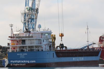
WILSON HANSA
General Cargo
Current Trip
| Time Travelled | 6 days |
|---|---|
| Remaining Time | 7 days |
| Distance Travelled | 665.40 nm |
| Remaining Distance | 1075.24 nm |
| AVG Speed | 8.1 Knots |
| MAX Speed | 13.5 Knots |
| AVG Wind | 16.7 knots |
| MAX Wind | 37 knots |
| MIN Temp | -1°C / 30.2°F |
| MAX Temp | 16.6°C / 61.88°F |
| Dybgang | 5.7 m |
| Position Modtaget | 3 h, 25 m siden |
Current Position
| Longitude | --- |
|---|---|
| Latitude | --- |
| Status | Under way using engine |
| Fart | 4.6 Knots |
| Kurs | 246° |
| Område | English Channel |
| Station | T-AIS |
| Position Modtaget | 3 h, 25 m siden |
Info
Information
The current position of WILSON HANSA is in English Channel with coordinates 49.74524° / -3.52176° as reported on 2024-11-26 01:42 by AIS to our vessel tracker app. The vessel's current speed is 4.6 Knots and is heading at the port of CEUTA. The estimated time of arrival as calculated by MyShipTracking vessel tracking app is 2024-12-04 05:30 LT
The vessel WILSON HANSA (IMO: 9583859, MMSI: 257755000) is a General Cargo that was built in 2013 ( 11 år gamle ). It's sailing under the flag of [NO] Norway.
In this page you can find informations about the vessels current position, last detected port calls, and current voyage information. If the vessels is not in coverage by AIS you will find the latest position.
The current position of WILSON HANSA is detected by our AIS receivers and we are not responsible for the reliability of the data. The last position was recorded while the vessel was in Coverage by the Ais receivers of our vessel tracking app.
The current draught of WILSON HANSA as reported by AIS is 5.7 meters
Weather
| Temperature | 11.8°C / 53.24°F |
|---|---|
| Wind Speed | 17 knots |
| Direction | 265° W |
| Pressure | 1014.3 hPa |
| Humidity | 67.2 % |
| Cloud Coverage | 77 % |
Featured Company
Last Port Calls
| Port | Arrival | Departure | Time In Port |
|---|---|---|---|
| 2024-11-18 18:00 | 2024-11-20 03:55 | 1 d | |
| 2024-11-14 05:13 | 2024-11-16 18:06 | 2 d | |
| 2024-10-28 07:04 | 2024-10-29 20:55 | 1 d | |
| 2024-10-26 20:44 | 2024-10-27 23:05 | 1 d | |
| 2024-10-15 20:02 | 2024-10-18 11:32 | 2 d | |
| 2024-10-09 07:13 | 2024-10-11 18:05 | 2 d | |
| 2024-10-02 11:50 | 2024-10-02 16:57 | 5 h | |
| 2024-09-22 17:13 | 2024-09-24 20:14 | 2 d | |
| 2024-09-16 15:49 | 2024-09-16 16:12 | 23 m | |
| 2024-09-15 03:04 | 2024-09-15 03:33 | 29 m |
Last Trips
| Origin | Departure | Destination | Arrival | Distance | |
|---|---|---|---|---|---|
| 2024-11-16 18:06 | 2024-11-18 18:00 | 422.13 nm | |||
| 2024-10-29 20:55 | 2024-11-14 05:13 | 3203.46 nm | |||
| 2024-10-27 23:05 | 2024-10-28 07:04 | 66.72 nm | |||
| 2024-10-18 11:32 | 2024-10-26 20:44 | 1451.84 nm | |||
| 2024-10-11 18:05 | 2024-10-15 20:02 | 977.23 nm | |||
| 2024-10-02 16:57 | 2024-10-09 07:13 | 1410.70 nm | |||
| 2024-09-24 20:14 | 2024-10-02 11:50 | 1433.48 nm | |||
| 2024-09-16 16:12 | 2024-09-22 17:13 | 259.98 nm | |||
| 2024-09-15 03:33 | 2024-09-16 15:49 | 0.48 nm | |||
| 2024-09-11 11:39 | 2024-09-15 03:04 | 190.09 nm |
Events
| Tid | Hændelsen | Detaljer | Position / Dest | Info |
|---|---|---|---|---|
| 2024-11-26 01:51 | Status er ændret | Default Under way using engine |
49.74018 / -3.53657
ESCEU
|
Fart: 4.6 kn Kurs: 246° |
| 2024-11-26 01:42 | Udenfor Dækning |
49.74524 / -3.52176
English Channel
ESCEU
|
Fart: 4.6 kn Kurs: 240.7° |
|
| 2024-11-26 00:12 | Status er ændret | Under way using engine Default |
49.80470 / -3.35092
ESCEU
|
Fart: 6 kn Kurs: 243° |
| 2024-11-26 00:10 | Status er ændret | Default Under way using engine |
49.80627 / -3.34626
ESCEU
|
Fart: 6 kn Kurs: 242.1° |
| 2024-11-26 00:00 | Status er ændret | Under way using engine Default |
49.81465 / -3.32214
ESCEU
|
Fart: 5.9 kn Kurs: 241° |
| 2024-11-25 23:55 | Status er ændret | Default Under way using engine |
49.81891 / -3.31045
ESCEU
|
Fart: 5.8 kn Kurs: 241.7° |
| 2024-11-25 23:54 | Status er ændret | Under way using engine Default |
49.81943 / -3.30898
ESCEU
|
Fart: 5.8 kn Kurs: 241° |
| 2024-11-25 23:54 | Fundet i havområde | United Kingdom part of the English Channel |
49.81943 / -3.30898
English Channel
ESCEU
|
Fart: 5.8 kn Kurs: 241.7° |
| 2024-11-25 23:46 | Indenfor Dækning |
49.81943 / -3.30898
English Channel
ESCEU
|
Fart: 5.8 kn Kurs: 241.7° |
|
| 2024-11-25 07:30 | START Sejllads | 7.24 nm, South East of ILE DE TATIHOU |
49.51993 / -1.09662
ESCEU
|
Fart: 5.6 kn Kurs: 23° |