
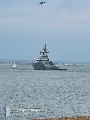
HMS TYNE
Military ops
Current Trip
Unknown
| Time Travelled | 1 day |
|---|---|
| Remaining Time | --- |
| Distance Travelled | 68.65 nm |
| Remaining Distance | --- |
| AVG Speed | 13.9 Knots |
| MAX Speed | 19.2 Knots |
| AVG Wind | 19.4 knots |
| MAX Wind | 20.7 knots |
| MIN Temp | 9.6°C / 49.28°F |
| MAX Temp | 10.1°C / 50.18°F |
| Dybgang | 3.8 m |
| Position Modtaget | 1 d siden |
Current Position
| Longitude | --- |
|---|---|
| Latitude | --- |
| Status | Under way using engine |
| Fart | 13.3 Knots |
| Kurs | 258° |
| Område | English Channel |
| Station | T-AIS |
| Position Modtaget | 1 d siden |
Info
Information
The current position of HMS TYNE is in English Channel with coordinates 50.50575° / -1.30442° as reported on 2025-02-24 16:29 by AIS to our vessel tracker app. The vessel's current speed is 13.3 Knots
The vessel HMS TYNE (IMO: 4327, MMSI: 232729000) is a Military ops It's sailing under the flag of [GB] United Kingdom.
In this page you can find informations about the vessels current position, last detected port calls, and current voyage information. If the vessels is not in coverage by AIS you will find the latest position.
The current position of HMS TYNE is detected by our AIS receivers and we are not responsible for the reliability of the data. The last position was recorded while the vessel was in Coverage by the Ais receivers of our vessel tracking app.
The current draught of HMS TYNE as reported by AIS is 3.8 meters
Weather
| Temperature | 9.6°C / 49.28°F |
|---|---|
| Wind Speed | 20 knots |
| Direction | 242° WSW |
| Pressure | 1014 hPa |
| Humidity | 85.3 % |
| Cloud Coverage | 1 % |
Featured Company
Last Port Calls
| Port | Arrival | Departure | Time In Port |
|---|---|---|---|
| 2025-02-22 14:00 | 2025-02-24 11:08 | 1 d | |
| 2025-02-17 10:24 | 2025-02-21 13:54 | 4 d | |
| 2025-02-11 09:05 | 2025-02-12 09:01 | 23 h | |
| 2025-02-11 08:52 | 2025-02-11 08:56 | 3 m | |
| 2025-02-11 08:46 | 2025-02-11 08:48 | 1 m | |
| 2025-02-07 16:10 | 2025-02-07 16:12 | 2 m | |
| 2025-02-05 13:22 | 2025-02-07 16:01 | 2 d | |
| 2025-01-30 18:27 | 2025-02-01 07:51 | 1 d | |
| 2024-12-21 08:27 | 2025-01-13 14:55 | 23 d | |
| 2024-12-18 09:23 | 2024-12-18 09:24 | 1 m |
Most Visited Ports (Last year)
| Port | Arrivals | |
|---|---|---|
| 23 | ||
| 10 | ||
| 7 | ||
| 4 | ||
| 1 | ||
| 1 |
Last Trips
| Origin | Departure | Destination | Arrival | Distance | |
|---|---|---|---|---|---|
| 2025-02-21 13:54 | 2025-02-22 14:00 | 191.53 nm | |||
| 2025-02-12 09:01 | 2025-02-17 10:24 | 376.73 nm | |||
| 2025-02-11 08:56 | 2025-02-11 09:05 | 1.38 nm | |||
| 2025-02-11 08:48 | 2025-02-11 08:52 | 0.90 nm | |||
| 2025-02-07 16:12 | 2025-02-11 08:46 | 76.63 nm | |||
| 2025-02-07 16:01 | 2025-02-07 16:10 | 1.86 nm | |||
| 2025-02-01 07:51 | 2025-02-05 13:22 | 744.25 nm | |||
| 2025-01-13 14:55 | 2025-01-30 18:27 | 1277.50 nm | |||
| 2024-12-18 09:24 | 2024-12-21 08:27 | 162.21 nm | |||
| 2024-12-12 11:45 | 2024-12-17 09:24 | 71.53 nm |
Events
| Tid | Hændelsen | Detaljer | Position / Dest | Info |
|---|---|---|---|---|
| 2025-02-24 16:29 | Udenfor Dækning |
50.50575 / -1.30442
English Channel
|
Fart: 13.3 kn Kurs: 258° |
|
| 2025-02-24 11:08 | Afsejlet fra sidste havn |
|
50.80699 / -1.11524
|
Fart: 8.3 kn Kurs: 221° |
| 2025-02-24 11:07 | START Sejllads |
50.80810 / -1.11074
[GB] PORTSMOUTH
|
Fart: 3.3 kn Kurs: 262° |
|
| 2025-02-24 10:56 | Status er ændret | Under way using engine Moored |
50.80721 / -1.10486
[GB] PORTSMOUTH
|
Fart: Kurs: 91° |
| 2025-02-24 10:37 | Indenfor Dækning |
50.80723 / -1.10487
English Channel
[GB] PORTSMOUTH
|
Fart: Kurs: 12.3° |
|
| 2025-02-22 14:10 | Udenfor Dækning |
50.80723 / -1.10489
English Channel
[GB] PORTSMOUTH
|
Fart: Kurs: 12.3° |
|
| 2025-02-22 14:10 | Status er ændret | Moored Under way using engine |
50.80723 / -1.10488
[GB] PORTSMOUTH
|
Fart: Kurs: 91° |
| 2025-02-22 14:00 | STOP Sejllads |
50.80683 / -1.10542
[GB] PORTSMOUTH
|
Fart: 0.3 kn Kurs: 110° |
|
| 2025-02-22 14:00 | Skibe i havn |
|
50.80683 / -1.10542
[GB] PORTSMOUTH
|
Fart: 0.8 kn Kurs: 112° |
| 2025-02-22 12:17 | Ændre havområde | United Kingdom part of the English Channel Belgian part of the North Sea |
50.53357 / -1.09072
English Channel
|
Fart: 14.2 kn Kurs: 55.7° |