
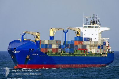
VENTO DI SCIROCCO
Container Ship
Current Trip
| Time Travelled | 3 days |
|---|---|
| Remaining Time | 1 day |
| Distance Travelled | 1025.05 nm |
| Remaining Distance | 289.26 nm |
| AVG Speed | 11.8 Knots |
| MAX Speed | 19.1 Knots |
| AVG Wind | 6.7 knots |
| MAX Wind | 16 knots |
| MIN Temp | 13.8°C / 56.84°F |
| MAX Temp | 21.3°C / 70.34°F |
| Dybgang | 8.6 m |
| Position Modtaget | 1 m siden |
Current Position
| Longitude | 24.72281° |
|---|---|
| Latitude | 38.15308° |
| Status | Under way using engine |
| Fart | 11.6 Knots |
| Kurs | 16.2° |
| Område | Aegean Sea |
| Station | T-AIS |
| Position Modtaget | 1 m siden |
Info
Information
The current position of VENTO DI SCIROCCO is in Aegean Sea with coordinates 38.15308° / 24.72281° as reported on 2024-05-14 00:40 by AIS to our vessel tracker app. The vessel's current speed is 11.6 Knots and is heading at the port of GEMLIK. The estimated time of arrival as calculated by MyShipTracking vessel tracking app is 2024-05-15 03:43 LT
The vessel VENTO DI SCIROCCO (IMO: 9305908, MMSI: 215426000) is a Container Ship that was built in 2005 ( 19 år gamle ). It's sailing under the flag of [MT] Malta.
In this page you can find informations about the vessels current position, last detected port calls, and current voyage information. If the vessels is not in coverage by AIS you will find the latest position.
The current position of VENTO DI SCIROCCO is detected by our AIS receivers and we are not responsible for the reliability of the data. The last position was recorded while the vessel was in Coverage by the Ais receivers of our vessel tracking app.
The current draught of VENTO DI SCIROCCO as reported by AIS is 8.6 meters
Weather
| Temperature | 16.5°C / 61.7°F |
|---|---|
| Wind Speed | 12 knots |
| Direction | 12° NNE |
| Pressure | 1016.3 hPa |
| Humidity | 69.9 % |
| Cloud Coverage | 66 % |
Featured Company
Last Port Calls
| Port | Arrival | Departure | Time In Port |
|---|---|---|---|
| 2024-05-09 04:02 | 2024-05-10 08:10 | 1 d | |
| 2024-05-07 18:49 | 2024-05-08 17:15 | 22 h | |
| 2024-05-06 04:30 | 2024-05-06 17:51 | 13 h | |
| 2024-05-03 06:45 | 2024-05-03 20:14 | 13 h | |
| 2024-05-01 10:04 | 2024-05-02 01:12 | 15 h | |
| 2024-04-30 11:53 | 2024-05-01 06:20 | 18 h | |
| 2024-04-29 09:59 | 2024-04-30 06:52 | 20 h | |
| 2024-04-24 03:16 | 2024-04-25 15:20 | 1 d | |
| 2024-04-22 20:41 | 2024-04-23 20:59 | 1 d | |
| 2024-04-21 04:22 | 2024-04-21 22:25 | 18 h |
Last Trips
| Origin | Departure | Destination | Arrival | Distance | |
|---|---|---|---|---|---|
| 2024-05-08 19:15 | 2024-05-09 06:02 | 57.13 nm | |||
| 2024-05-06 19:51 | 2024-05-07 20:49 | 365.95 nm | |||
| 2024-05-03 23:14 | 2024-05-06 06:30 | 799.67 nm | |||
| 2024-05-02 04:12 | 2024-05-03 09:45 | 262.99 nm | |||
| 2024-05-01 09:20 | 2024-05-01 13:04 | 45.92 nm | |||
| 2024-04-30 09:52 | 2024-04-30 14:53 | 61.09 nm | |||
| 2024-04-25 17:20 | 2024-04-29 12:59 | 1316.31 nm | |||
| 2024-04-23 22:59 | 2024-04-24 05:16 | 54.56 nm | |||
| 2024-04-22 00:25 | 2024-04-22 22:41 | 366.93 nm | |||
| 2024-04-18 14:46 | 2024-04-21 06:22 | 804.21 nm |
Events
| Tid | Hændelsen | Detaljer | Position / Dest | Info |
|---|---|---|---|---|
| 2024-05-13 16:52 | Status er ændret | Under way using engine Default |
36.99572 / 23.68850
TRGEM
|
Fart: 11 kn Kurs: 28° |
| 2024-05-13 16:46 | Status er ændret | Default Under way using engine |
36.97666 / 23.67500
TRGEM
|
Fart: 11.3 kn Kurs: 29° |
| 2024-05-13 16:41 | Status er ændret | Under way using engine Default |
36.96466 / 23.66747
TRGEM
|
Fart: 11 kn Kurs: 31° |
| 2024-05-13 16:30 | Status er ændret | Default Under way using engine |
36.93500 / 23.64500
TRGEM
|
Fart: 11.3 kn Kurs: 32.2° |
| 2024-05-13 12:26 | Ændre havområde | Greek part of the Aegean Sea Greek part of the Mediterranean Sea - Eastern Basin |
36.39774 / 23.02445
Aegean Sea
TRGEM
|
Fart: 11.8 kn Kurs: 99.4° |
| 2024-05-13 12:13 | Ændre havområde | Greek part of the Mediterranean Sea - Eastern Basin Greek part of the Ionian Sea |
36.40643 / 22.97002
Mediterranean Sea - Eastern Basin
TRGEM
|
Fart: 12.2 kn Kurs: 103.3° |
| 2024-05-13 12:13 | Status er ændret | Under way using engine Default |
36.40667 / 22.96873
TRGEM
|
Fart: 12 kn Kurs: 92° |
| 2024-05-13 12:00 | Indenfor Dækning |
36.40643 / 22.97002
Mediterranean Sea - Eastern Basin
TRGEM
|
Fart: 12.2 kn Kurs: 103.3° |
|
| 2024-05-13 03:33 | Status er ændret | Default Under way using engine |
36.68294 / 20.89849
TRGEM
|
Fart: 11.7 kn Kurs: 105° |
| 2024-05-13 03:16 | Udenfor Dækning |
36.69724 / 20.83329
Ionian Sea
TRGEM
|
Fart: 11.7 kn Kurs: 105° |