
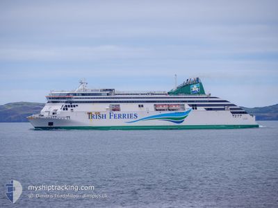
ULYSSES
Ro-Ro/Passenger Ship
Current Trip
| Time Travelled | 3 h, 41 mins |
|---|---|
| Remaining Time | -8 mins |
| Distance Travelled | 54.81 nm |
| Remaining Distance | 3.99 nm |
| AVG Speed | 15.6 Knots |
| MAX Speed | 17.2 Knots |
| AVG Wind | 11.2 knots |
| MAX Wind | 17.3 knots |
| MIN Temp | 8°C / 46.4°F |
| MAX Temp | 10.5°C / 50.9°F |
| Dybgang | 6.1 m |
| Position Modtaget | 2 m siden |
Current Position
| Longitude | --- |
|---|---|
| Latitude | --- |
| Status | Under way using engine |
| Fart | 8.1 Knots |
| Kurs | 102.5° |
| Område | Irish Sea and St. George's Channel |
| Station | T-AIS |
| Position Modtaget | 2 m siden |
Info
Information
The current position of ULYSSES is in Irish Sea and St. George's Channel with coordinates 53.33567° / -4.62115° as reported on 2025-12-12 12:13 by AIS to our vessel tracker app. The vessel's current speed is 8.1 Knots and is heading at the port of HOLYHEAD. The estimated time of arrival as calculated by MyShipTracking vessel tracking app is 2025-12-12 12:08 LT
The vessel ULYSSES (IMO: 9214991, MMSI: 209952000) is a Ro-Ro/Passenger Ship that was built in 2001 ( 24 år gamle ). It's sailing under the flag of [CY] Cyprus.
In this page you can find informations about the vessels current position, last detected port calls, and current voyage information. If the vessels is not in coverage by AIS you will find the latest position.
The current position of ULYSSES is detected by our AIS receivers and we are not responsible for the reliability of the data. The last position was recorded while the vessel was in Coverage by the Ais receivers of our vessel tracking app.
The current draught of ULYSSES as reported by AIS is 6.1 meters
Weather
| Temperature | 10.5°C / 50.9°F |
|---|---|
| Wind Speed | 17 knots |
| Direction | 231° SW |
| Pressure | 1015.4 hPa |
| Humidity | 70.4 % |
| Cloud Coverage | 93 % |
Featured Company
Last Port Calls
| Port | Arrival | Departure | Time In Port |
|---|---|---|---|
| 2025-12-12 06:50 | 2025-12-12 08:35 | 1 h | |
| 2025-12-12 02:38 | 2025-12-12 03:55 | 1 h | |
| 2025-12-11 21:08 | 2025-12-11 23:55 | 2 h | |
| 2025-12-11 13:51 | 2025-12-11 16:53 | 3 h | |
| 2025-12-11 07:46 | 2025-12-11 10:28 | 2 h | |
| 2025-12-11 01:15 | 2025-12-11 04:32 | 3 h | |
| 2025-12-10 17:43 | 2025-12-10 21:20 | 3 h | |
| 2025-12-10 13:00 | 2025-12-10 14:41 | 1 h | |
| 2025-12-10 08:20 | 2025-12-10 10:14 | 1 h | |
| 2025-12-10 01:11 | 2025-12-10 04:54 | 3 h |
Last Trips
| Origin | Departure | Destination | Arrival | Distance | |
|---|---|---|---|---|---|
| 2025-12-12 03:55 | 2025-12-12 06:50 | 58.56 nm | |||
| 2025-12-11 23:55 | 2025-12-12 02:38 | 56.92 nm | |||
| 2025-12-11 16:53 | 2025-12-11 21:08 | 61.68 nm | |||
| 2025-12-11 10:28 | 2025-12-11 13:51 | 59.94 nm | |||
| 2025-12-11 04:32 | 2025-12-11 07:46 | 60.49 nm | |||
| 2025-12-10 21:20 | 2025-12-11 01:15 | 64.95 nm | |||
| 2025-12-10 14:41 | 2025-12-10 17:43 | 58.42 nm | |||
| 2025-12-10 10:14 | 2025-12-10 13:00 | 57.55 nm | |||
| 2025-12-10 04:54 | 2025-12-10 08:20 | 58.80 nm | |||
| 2025-12-09 22:07 | 2025-12-10 01:11 | 58.80 nm |
Events
| Tid | Hændelsen | Detaljer | Position / Dest | Info |
|---|---|---|---|---|
| 2025-12-12 12:00 | Status er ændret | Under way using engine Default |
53.34140 / -4.68159
DUBLIN<>HOLYHEAD
|
Fart: 10.9 kn Kurs: 85° |
| 2025-12-12 11:59 | Status er ændret | Default Under way using engine |
53.34119 / -4.68816
DUBLIN<>HOLYHEAD
|
Fart: 10.7 kn Kurs: 86.6° |
| 2025-12-12 11:26 | Status er ændret | Under way using engine Default |
53.32594 / -4.91498
DUBLIN<>HOLYHEAD
|
Fart: 16.4 kn Kurs: 95° |
| 2025-12-12 11:15 | Status er ændret | Default Under way using engine |
53.32930 / -4.99564
DUBLIN<>HOLYHEAD
|
Fart: 16.4 kn Kurs: 99.9° |
| 2025-12-12 11:07 | Status er ændret | Under way using engine Default |
53.33544 / -5.05567
DUBLIN<>HOLYHEAD
|
Fart: 16.5 kn Kurs: 100° |
| 2025-12-12 10:55 | Status er ændret | Default Under way using engine |
53.34106 / -5.14628
DUBLIN<>HOLYHEAD
|
Fart: 16.7 kn Kurs: 90.9° |
| 2025-12-12 10:35 | Ændre havområde | United Kingdom part of the Irish Sea and St. George's Channel Irish part of the Irish Sea and St. George's Channel |
53.34582 / -5.30147
Irish Sea and St. George's Channel
DUBLIN<>HOLYHEAD
|
Fart: 16.5 kn Kurs: 94.3° |
| 2025-12-12 08:35 | Afsejlet fra sidste havn |
|
53.34354 / -6.17477
DUBLIN<>HOLYHEAD
|
Fart: 10.3 kn Kurs: 90° |
| 2025-12-12 08:29 | START Sejllads |
53.34321 / -6.19493
[IE] DUBLIN
|
Fart: 3.8 kn Kurs: 209° |
|
| 2025-12-12 08:26 | Dybgangen er ændret | 6.1 6.2 |
53.34500 / -6.19583
[IE] DUBLIN
|
Fart: 0.6 kn Kurs: 271° |