
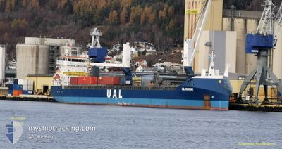
UAL COLOGNE
General Cargo
Current Trip
| Time Travelled | 1 day |
|---|---|
| Remaining Time | 9 h, 8 mins |
| Distance Travelled | 344.72 nm |
| Remaining Distance | 97.92 nm |
| AVG Speed | 11.2 Knots |
| MAX Speed | 12.6 Knots |
| AVG Wind | 22.7 knots |
| MAX Wind | 31.8 knots |
| MIN Temp | 7.5°C / 45.5°F |
| MAX Temp | 9.9°C / 49.82°F |
| Dybgang | 7 m |
| Position Modtaget | Nu |
Current Position
| Longitude | 8.45382° |
|---|---|
| Latitude | 57.86795° |
| Status | Under way using engine |
| Fart | 10.1 Knots |
| Kurs | 64.9° |
| Område | Skaggerak |
| Station | T-AIS |
| Position Modtaget | Nu |
Info
Information
The current position of UAL COLOGNE is in Skaggerak with coordinates 57.86795° / 8.45382° as reported on 2024-05-01 09:20 by AIS to our vessel tracker app. The vessel's current speed is 10.1 Knots and is heading at the port of LARVIK. The estimated time of arrival as calculated by MyShipTracking vessel tracking app is 2024-05-01 18:28 LT
The vessel UAL COLOGNE (IMO: 9681534, MMSI: 244620675) is a General Cargo that was built in 2014 ( 10 år gamle ). It's sailing under the flag of [NL] Netherlands.
In this page you can find informations about the vessels current position, last detected port calls, and current voyage information. If the vessels is not in coverage by AIS you will find the latest position.
The current position of UAL COLOGNE is detected by our AIS receivers and we are not responsible for the reliability of the data. The last position was recorded while the vessel was in Coverage by the Ais receivers of our vessel tracking app.
The current draught of UAL COLOGNE as reported by AIS is 7 meters
Weather
| Temperature | 8.9°C / 48.02°F |
|---|---|
| Wind Speed | 26 knots |
| Direction | 53° NE |
| Pressure | 1020.5 hPa |
| Humidity | 80.7 % |
| Cloud Coverage | 80 % |
Featured Company
Last Port Calls
| Port | Arrival | Departure | Time In Port |
|---|---|---|---|
| 2024-04-27 14:47 | 2024-04-30 02:39 | 2 d | |
| 2024-04-17 18:04 | 2024-04-25 14:46 | 7 d | |
| 2024-03-28 05:05 | 2024-04-14 07:17 | 17 d | |
| 2024-03-28 04:28 | 2024-03-28 04:40 | 12 m | |
| 2024-03-18 18:05 | 2024-03-18 20:40 | 2 h | |
| 2024-03-10 18:50 | 2024-03-13 15:46 | 2 d | |
| 2024-03-07 12:11 | 2024-03-08 13:09 | 1 d |
Last Trips
| Origin | Departure | Destination | Arrival | Distance | |
|---|---|---|---|---|---|
| 2024-04-25 16:46 | 2024-04-27 15:47 | 463.54 nm | |||
| 2024-04-14 09:17 | 2024-04-17 20:04 | 853.79 nm | |||
| 2024-03-28 05:40 | 2024-03-28 06:05 | 1.77 nm | |||
| 2024-03-18 20:40 | 2024-03-28 05:28 | 1984.27 nm | |||
| 2024-03-13 15:46 | 2024-03-18 18:05 | 985.20 nm | |||
| 2024-03-08 13:09 | 2024-03-10 18:50 | 558.99 nm | |||
| 2024-02-21 20:14 | 2024-03-07 12:11 | 3394.18 nm |
Events
| Tid | Hændelsen | Detaljer | Position / Dest | Info |
|---|---|---|---|---|
| 2024-05-01 06:26 | Ændre havområde | Norwegian part of the Skaggerak Norwegian part of the North Sea |
57.69025 / 7.56645
Skaggerak
NOLAR
|
Fart: 10.3 kn Kurs: 86.9° |
| 2024-04-30 20:57 | Status er ændret | Under way using engine Default |
57.60630 / 4.39585
NOLAR
|
Fart: 10.7 kn Kurs: 78° |
| 2024-04-30 20:49 | Status er ændret | Default Under way using engine |
57.60352 / 4.34663
NOLAR
|
Fart: 11.1 kn Kurs: 83.6° |
| 2024-04-30 20:20 | Status er ændret | Under way using engine Default |
57.59455 / 4.18717
NOLAR
|
Fart: 10.8 kn Kurs: 84° |
| 2024-04-30 20:03 | Status er ændret | Default Under way using engine |
57.58970 / 4.09439
NOLAR
|
Fart: 11.3 kn Kurs: 86.3° |
| 2024-04-30 19:38 | Status er ændret | Under way using engine Default |
57.58215 / 3.94930
NOLAR
|
Fart: 11.2 kn Kurs: 86° |
| 2024-04-30 19:26 | Status er ændret | Default Under way using engine |
57.57858 / 3.87930
NOLAR
|
Fart: 11.2 kn Kurs: 82.2° |
| 2024-04-30 19:17 | Fundet i havområde | Norwegian part of the North Sea |
57.57619 / 3.83026
North Sea
NOLAR
|
Fart: 11.2 kn Kurs: 82.2° |
| 2024-04-30 19:17 | Indenfor Dækning |
57.57619 / 3.83026
North Sea
NOLAR
|
Fart: 11.2 kn Kurs: 82.2° |
|
| 2024-04-30 04:59 | Udenfor Dækning |
57.21554 / -1.26317
North Sea
NOLAR
|
Fart: 11.6 kn Kurs: 80° |