
TRITO NAVIGATOR
General Cargo
Current Trip
| Time Travelled | 2 days |
|---|---|
| Remaining Time | --- |
| Distance Travelled | 634.43 nm |
| Remaining Distance | --- |
| AVG Speed | 11.9 Knots |
| MAX Speed | 13.7 Knots |
| AVG Wind | 16 knots |
| MAX Wind | 32.3 knots |
| MIN Temp | 6.1°C / 42.98°F |
| MAX Temp | 16.8°C / 62.24°F |
| Dybgang | 6.2 m |
| Position Modtaget | Nu |
Current Position
| Longitude | --- |
|---|---|
| Latitude | --- |
| Status | Under way using engine |
| Fart | 10.3 Knots |
| Kurs | 264.4° |
| Område | Alboran Sea |
| Station | T-AIS |
| Position Modtaget | Nu |
Info
Information
The current position of TRITO NAVIGATOR is in Alboran Sea with coordinates 36.20100° / -4.14082° as reported on 2025-02-17 01:04 by AIS to our vessel tracker app. The vessel's current speed is 10.3 Knots and is heading at the port of BOULOGNE-SUR-MER. The estimated time of arrival as calculated by MyShipTracking vessel tracking app is 2025-02-21 17:00 LT
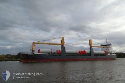
The vessel TRITO NAVIGATOR (IMO: 9631357, MMSI: 245237000) is a General Cargo that was built in 2013 ( 12 år gamle ). It's sailing under the flag of [NL] Netherlands.
In this page you can find informations about the vessels current position, last detected port calls, and current voyage information. If the vessels is not in coverage by AIS you will find the latest position.
The current position of TRITO NAVIGATOR is detected by our AIS receivers and we are not responsible for the reliability of the data. The last position was recorded while the vessel was in Coverage by the Ais receivers of our vessel tracking app.
The current draught of TRITO NAVIGATOR as reported by AIS is 6.2 meters
Weather
| Temperature | 15.8°C / 60.44°F |
|---|---|
| Wind Speed | 15 knots |
| Direction | 272° W |
| Pressure | 1015.9 hPa |
| Humidity | 79.6 % |
| Cloud Coverage | --- |
Featured Company
Last Port Calls
| Port | Arrival | Departure | Time In Port |
|---|---|---|---|
| 2025-02-13 21:19 | 2025-02-14 19:31 | 22 h | |
| 2025-02-07 06:35 | 2025-02-08 12:09 | 1 d | |
| 2025-02-01 07:33 | 2025-02-03 12:01 | 2 d | |
| 2025-01-26 16:17 | 2025-01-28 20:25 | 2 d | |
| 2025-01-16 13:55 | 2025-01-16 22:20 | 8 h | |
| 2025-01-12 18:33 | 2025-01-15 12:25 | 2 d | |
| 2024-12-31 09:34 | 2025-01-02 10:54 | 2 d | |
| 2024-12-23 08:49 | 2024-12-29 20:25 | 6 d | |
| 2024-12-13 04:38 | 2024-12-13 22:36 | 17 h |
Last Trips
| Origin | Departure | Destination | Arrival | Distance | |
|---|---|---|---|---|---|
| 2025-02-08 15:09 | 2025-02-13 22:19 | 1353.98 nm | |||
| 2025-02-03 13:01 | 2025-02-07 09:35 | 773.76 nm | |||
| 2025-01-28 21:25 | 2025-02-01 08:33 | 1005.18 nm | |||
| 2025-01-17 00:20 | 2025-01-26 17:17 | 2585.77 nm | |||
| 2025-01-15 13:25 | 2025-01-16 15:55 | 294.60 nm | |||
| 2025-01-02 12:54 | 2025-01-12 19:33 | 943.37 nm | |||
| 2024-12-29 22:25 | 2024-12-31 11:34 | 407.03 nm | |||
| 2024-12-13 23:36 | 2024-12-23 10:49 | 2286.76 nm | |||
| 2024-11-29 10:18 | 2024-12-13 05:38 | 3879.03 nm |
Events
| Tid | Hændelsen | Detaljer | Position / Dest | Info |
|---|---|---|---|---|
| 2025-02-16 21:07 | Status er ændret | Under way using engine Default |
36.29750 / -3.26538
FRBOL
|
Fart: 11.9 kn Kurs: 262° |
| 2025-02-16 20:58 | Indenfor Dækning |
36.29710 / -3.26863
Alboran Sea
FRBOL
|
Fart: 11.7 kn Kurs: 261.9° |
|
| 2025-02-16 19:53 | Status er ændret | Default Under way using engine |
36.33292 / -2.97207
FRBOL
|
Fart: 11.3 kn Kurs: 262° |
| 2025-02-16 19:52 | Udenfor Dækning |
36.33320 / -2.96963
Alboran Sea
FRBOL
|
Fart: 11.3 kn Kurs: 262° |
|
| 2025-02-16 19:46 | Status er ændret | Under way using engine Default |
36.33630 / -2.94427
FRBOL
|
Fart: 11.2 kn Kurs: 262° |
| 2025-02-16 19:06 | Status er ændret | Default Under way using engine |
36.35453 / -2.79353
FRBOL
|
Fart: 10.6 kn Kurs: 261.1° |
| 2025-02-16 18:51 | Status er ændret | Under way using engine Default |
36.36072 / -2.74207
FRBOL
|
Fart: 10.7 kn Kurs: 262° |
| 2025-02-16 18:47 | Status er ændret | Default Under way using engine |
36.36278 / -2.72508
FRBOL
|
Fart: 11.1 kn Kurs: 262.5° |
| 2025-02-16 18:35 | Status er ændret | Under way using engine Default |
36.36812 / -2.68053
FRBOL
|
Fart: 11.3 kn Kurs: 260° |
| 2025-02-16 18:27 | Status er ændret | Default Under way using engine |
36.37168 / -2.65195
FRBOL
|
Fart: 11.4 kn Kurs: 262° |