
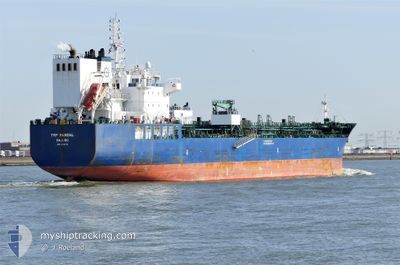
TRF MANDAL
Tanker B
Current Trip
| Time Travelled | 2 days |
|---|---|
| Remaining Time | 1 day |
| Distance Travelled | 811.91 nm |
| Remaining Distance | 563.14 nm |
| AVG Speed | 12.5 Knots |
| MAX Speed | 16 Knots |
| AVG Wind | 7.2 knots |
| MAX Wind | 12 knots |
| MIN Temp | 22.2°C / 71.96°F |
| MAX Temp | 27.6°C / 81.68°F |
| Dybgang | 10.8 m |
| Position Modtaget | 2 d siden |
Current Position
| Longitude | -90.01668° |
|---|---|
| Latitude | 29.78575° |
| Status | Under way using engine |
| Fart | 14.5 Knots |
| Kurs | 211° |
| Område | Gulf of Mexico |
| Station | T-AIS |
| Position Modtaget | 2 d siden |
Info
Information
The current position of TRF MANDAL is in Gulf of Mexico with coordinates 29.78575° / -90.01668° as reported on 2024-04-30 00:31 by AIS to our vessel tracker app. The vessel's current speed is 14.5 Knots and is heading at the port of CRISTOBAL. The estimated time of arrival as calculated by MyShipTracking vessel tracking app is 2024-05-04 14:54 LT
The vessel TRF MANDAL (IMO: 9732773, MMSI: 538006542) is a Tanker B It's sailing under the flag of [MH] Marshall Is.
In this page you can find informations about the vessels current position, last detected port calls, and current voyage information. If the vessels is not in coverage by AIS you will find the latest position.
The current position of TRF MANDAL is detected by our AIS receivers and we are not responsible for the reliability of the data. The last position was recorded while the vessel was in Coverage by the Ais receivers of our vessel tracking app.
The current draught of TRF MANDAL as reported by AIS is 10.8 meters
Weather
| Temperature | 27.5°C / 81.5°F |
|---|---|
| Wind Speed | 11 knots |
| Direction | 48° NE |
| Pressure | 1010.9 hPa |
| Humidity | 70.5 % |
| Cloud Coverage | --- |
Featured Company
Last Port Calls
| Port | Arrival | Departure | Time In Port |
|---|---|---|---|
| 2024-04-23 23:14 | 2024-04-30 00:42 | 6 d | |
| 2024-04-18 00:59 | 2024-04-22 05:00 | 4 d | |
| 2024-03-05 21:19 | 2024-04-09 05:47 |
Most Visited Ports (Last year)
| Port | Arrivals | |
|---|---|---|
| 3 | ||
| 2 | ||
| 2 | ||
| 1 | ||
| 1 | ||
| 1 |
Last Trips
| Origin | Departure | Destination | Arrival | Distance | |
|---|---|---|---|---|---|
| 2024-04-22 00:00 | 2024-04-23 18:14 | 434.44 nm | |||
| 2024-04-09 00:47 | 2024-04-17 19:59 | 937.50 nm | |||
| 2024-02-07 19:53 | 2024-03-05 15:19 | 8265.13 nm |
Events
| Tid | Hændelsen | Detaljer | Position / Dest | Info |
|---|---|---|---|---|
| 2024-04-30 00:42 | Afsejlet fra sidste havn |
|
29.74698 / -90.01668
PACTB
|
Fart: 14.4 kn Kurs: 163° |
| 2024-04-30 00:38 | Status er ændret | Default Under way using engine |
29.76067 / -90.02550
[US] NEW ORLEANS
|
Fart: 14.5 kn Kurs: 211° |
| 2024-04-30 00:31 | Udenfor Dækning |
29.78575 / -90.01668
Gulf of Mexico
PACTB
|
Fart: 14.5 kn Kurs: 211.9° |
|
| 2024-04-29 23:51 | START Sejllads |
29.87349 / -89.94591
[US] NEW ORLEANS
|
Fart: 3.9 kn Kurs: 320° |
|
| 2024-04-29 22:59 | Dybgangen er ændret | 10.8 10.7 |
29.87152 / -89.94573
[US] NEW ORLEANS
|
Fart: Kurs: 120° |
| 2024-04-29 22:59 | Destination er ændret | PACTB USMSY |
29.87152 / -89.94573
[US] NEW ORLEANS
|
Fart: Kurs: 120° |
| 2024-04-29 22:59 | ETA er ændret | 2024/05/04 19:00 2024/04/23 10:00 |
29.87152 / -89.94573
[US] NEW ORLEANS
|
Fart: Kurs: 120° |
| 2024-04-29 22:59 | Status er ændret | Under way using engine Default |
29.87152 / -89.94573
[US] NEW ORLEANS
|
Fart: Kurs: 120° |
| 2024-04-29 22:50 | Indenfor Dækning |
29.87152 / -89.94573
Gulf of Mexico
[US] NEW ORLEANS
|
Fart: Kurs: 121.7° |
|
| 2024-04-29 11:56 | Udenfor Dækning |
29.87150 / -89.94573
Gulf of Mexico
[US] NEW ORLEANS
|
Fart: Kurs: 121.7° |