
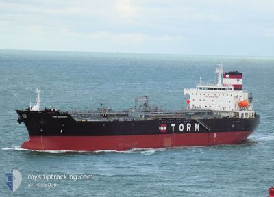
TORM RESILIENCE
Tanker
Current Trip
| Time Travelled | 15 h, 35 mins |
|---|---|
| Remaining Time | --- |
| Distance Travelled | 9.74 nm |
| Remaining Distance | --- |
| AVG Speed | 7.9 Knots |
| MAX Speed | 10.5 Knots |
| AVG Wind | 7.8 knots |
| MAX Wind | 11.3 knots |
| MIN Temp | 13°C / 55.4°F |
| MAX Temp | 22.7°C / 72.86°F |
| Dybgang | 8.5 m |
| Position Modtaget | 3 m siden |
Current Position
| Longitude | 31.12494° |
|---|---|
| Latitude | -29.74005° |
| Status | At anchor |
| Fart | 0.7 Knots |
| Kurs | 141° |
| Område | Indian Ocean |
| Station | T-AIS |
| Position Modtaget | 3 m siden |
Info
Information
The current position of TORM RESILIENCE is in Indian Ocean with coordinates -29.74005° / 31.12494° as reported on 2024-06-05 06:38 by AIS to our vessel tracker app. The vessel's current speed is 0.7 Knots and is heading at the port of HAMRIYA. The estimated time of arrival as calculated by MyShipTracking vessel tracking app is 2024-06-17 12:00 LT
The vessel TORM RESILIENCE (IMO: 930458800, MMSI: 219027876) is a Tanker It's sailing under the flag of [DK] Denmark.
In this page you can find informations about the vessels current position, last detected port calls, and current voyage information. If the vessels is not in coverage by AIS you will find the latest position.
The current position of TORM RESILIENCE is detected by our AIS receivers and we are not responsible for the reliability of the data. The last position was recorded while the vessel was in Coverage by the Ais receivers of our vessel tracking app.
The current draught of TORM RESILIENCE as reported by AIS is 8.5 meters
Weather
| Temperature | 15°C / 59°F |
|---|---|
| Wind Speed | 6 knots |
| Direction | 292° WNW |
| Pressure | 1009.5 hPa |
| Humidity | 53.5 % |
| Cloud Coverage | --- |
Featured Company
Last Port Calls
| Port | Arrival | Departure | Time In Port |
|---|---|---|---|
| 2024-06-01 20:34 | 2024-06-04 17:07 | 2 d | |
| 2024-04-26 07:31 | 2024-04-27 21:23 | 1 d | |
| 2024-04-23 08:16 | 2024-04-25 09:22 | 2 d | |
| 2024-04-19 11:06 | 2024-04-21 19:39 | 2 d | |
| 2024-04-01 08:31 |
Most Visited Ports (Last year)
| Port | Arrivals | |
|---|---|---|
| 3 | ||
| 3 | ||
| 2 | ||
| 2 | ||
| 2 | ||
| 1 |
Last Trips
| Origin | Departure | Destination | Arrival | Distance | |
|---|---|---|---|---|---|
| 2024-04-27 21:23 | 2024-06-01 20:34 | 7572.21 nm | |||
| 2024-04-25 09:22 | 2024-04-26 07:31 | 163.47 nm | |||
| 2024-04-21 19:39 | 2024-04-23 08:16 | 298.23 nm | |||
| 2024-04-01 08:31 | 2024-04-19 11:06 | 5023.01 nm |
Events
| Tid | Hændelsen | Detaljer | Position / Dest | Info |
|---|---|---|---|---|
| 2024-06-04 16:47 | STOP Sejllads | 9.64 nm, North East of DURBAN |
-29.74252 / 31.12450
HAMRIYAH
|
Fart: 0.2 kn Kurs: 48° |
| 2024-06-04 16:23 | Status er ændret | At anchor Under way using engine |
-29.74268 / 31.12575
HAMRIYAH
|
Fart: 1.4 kn Kurs: 26° |
| 2024-06-04 15:41 | Status er ændret | Under way using engine Moored |
-29.80841 / 31.13354
HAMRIYAH
|
Fart: 9.7 kn Kurs: 10° |
| 2024-06-04 15:07 | Afsejlet fra sidste havn |
|
-29.86774 / 31.05836
HAMRIYAH
|
Fart: 10.5 kn Kurs: 38° |
| 2024-06-04 14:56 | START Sejllads |
-29.88661 / 31.03633
[ZA] DURBAN
|
Fart: 3.6 kn Kurs: 57° |
|
| 2024-06-04 14:00 | Destination er ændret | HAMRIYAH SIKKA |
-29.88778 / 31.03486
[ZA] DURBAN
|
Fart: Kurs: 64° |
| 2024-06-04 11:41 | Dybgangen er ændret | 8.5 8.6 |
-29.88782 / 31.03491
[ZA] DURBAN
|
Fart: Kurs: 64° |
| 2024-06-04 10:31 | Status er ændret | Moored Default |
-29.88781 / 31.03489
[ZA] DURBAN
|
Fart: Kurs: 64° |
| 2024-06-04 10:28 | Status er ændret | Default Moored |
-29.88781 / 31.03489
[ZA] DURBAN
|
Fart: Kurs: 64° |
| 2024-06-04 10:04 | Status er ændret | Moored Default |
-29.88780 / 31.03485
[ZA] DURBAN
|
Fart: Kurs: 64° |