

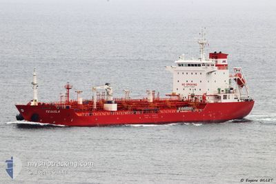
TEQUILA
Oil/Chemical Tanker

Current Trip
| Time Travelled | 1 day |
|---|---|
| Remaining Time | --- |
| Distance Travelled | 235.20 nm |
| Remaining Distance | --- |
| AVG Speed | 9.7 Knots |
| MAX Speed | 13.6 Knots |
| AVG Wind | 12.1 knots |
| MAX Wind | 16.7 knots |
| MIN Temp | 4.1°C / 39.38°F |
| MAX Temp | 9.6°C / 49.28°F |
| Dybgang | 6.3 m |
| Position Modtaget | 2 m siden |
Current Position
| Longitude | --- |
|---|---|
| Latitude | --- |
| Status | At anchor |
| Fart | |
| Kurs | 77° |
| Område | English Channel |
| Station | T-AIS |
| Position Modtaget | 2 m siden |
Information
The current position of TEQUILA is in English Channel with coordinates 50.61389° / -1.07546° as reported on 2025-03-29 15:49 by AIS to our vessel tracker app. The vessel's current speed is 0 Knots
The vessel TEQUILA (IMO: 9345219, MMSI: 538002883) is a Oil/Chemical Tanker that was built in 2007 ( 18 år gamle ). It's sailing under the flag of [MH] Marshall Is.
In this page you can find informations about the vessels current position, last detected port calls, and current voyage information. If the vessels is not in coverage by AIS you will find the latest position.
The current position of TEQUILA is detected by our AIS receivers and we are not responsible for the reliability of the data. The last position was recorded while the vessel was in Coverage by the Ais receivers of our vessel tracking app.
The current draught of TEQUILA as reported by AIS is 6.3 meters
Weather
| Temperature | 8.7°C / 47.66°F |
|---|---|
| Wind Speed | 15 knots |
| Direction | 249° WSW |
| Pressure | 1023.5 hPa |
| Humidity | 78.6 % |
| Cloud Coverage | 64 % |


Featured Company
Last Port Calls
| Port | Arrival | Departure | Time In Port |
|---|---|---|---|
| 2025-03-26 20:45 | 2025-03-28 14:56 | 1 d | |
| 2025-03-23 14:14 | 2025-03-24 17:14 | 1 d | |
| 2025-03-18 23:28 | 2025-03-19 00:08 | 39 m | |
| 2025-03-16 13:58 | 2025-03-18 23:01 | 2 d | |
| 2025-03-16 12:26 | 2025-03-16 13:23 | 56 m | |
| 2025-03-16 03:26 | 2025-03-16 09:45 | 6 h | |
| 2025-03-12 07:06 | 2025-03-13 10:48 | 1 d | |
| 2025-03-12 05:38 | 2025-03-12 06:31 | 52 m | |
| 2025-03-06 15:11 | 2025-03-06 15:45 | 34 m | |
| 2025-03-04 16:41 | 2025-03-06 09:18 | 1 d |
Last Trips
| Origin | Departure | Destination | Arrival | Distance | |
|---|---|---|---|---|---|
| 2025-03-24 17:14 | 2025-03-26 20:45 | 317.55 nm | |||
| 2025-03-19 00:08 | 2025-03-23 14:14 | 568.85 nm | |||
| 2025-03-18 23:01 | 2025-03-18 23:28 | 1.98 nm | |||
| 2025-03-16 13:23 | 2025-03-16 13:58 | 2.03 nm | |||
| 2025-03-13 10:48 | 2025-03-16 12:26 | 755.66 nm | |||
| 2025-03-13 10:48 | 2025-03-16 03:26 | 726.27 nm | |||
| 2025-03-12 06:31 | 2025-03-12 07:06 | 4.76 nm | |||
| 2025-03-06 15:45 | 2025-03-12 05:38 | 792.68 nm | |||
| 2025-03-06 09:18 | 2025-03-06 15:11 | 1.95 nm | |||
| 2025-03-04 16:07 | 2025-03-04 16:41 | 2.11 nm |
Events
| Tid | Hændelsen | Detaljer | Position / Dest | Info |
|---|---|---|---|---|
| 2025-03-29 11:55 | STOP Sejllads | 3.71 nm, South East of SANDOWN |
50.61387 / -1.07544
GB FAW
|
Fart: 0.1 kn Kurs: 77° |
| 2025-03-29 11:40 | Status er ændret | At anchor Under way using engine |
50.61473 / -1.07478
GB FAW
|
Fart: 2.1 kn Kurs: 18° |
| 2025-03-29 01:19 | Ændre havområde | United Kingdom part of the English Channel United Kingdom part of the North Sea |
51.07558 / 1.46417
English Channel
GB FAW
|
Fart: 9 kn Kurs: 237.2° |
| 2025-03-28 20:09 | ETA er ændret | 2025/03/29 11:00 2025/03/30 11:00 |
51.76460 / 2.42778
GB FAW
|
Fart: 13.4 kn Kurs: 221.5° |
| 2025-03-28 20:02 | Ændre havområde | United Kingdom part of the North Sea Belgian part of the North Sea |
51.78520 / 2.45737
North Sea
GB FAW
|
Fart: 13.4 kn Kurs: 221.4° |
| 2025-03-28 19:38 | Ændre havområde | Belgian part of the North Sea Dutch part of the North Sea |
51.85181 / 2.55291
North Sea
GB FAW
|
Fart: 13.4 kn Kurs: 221.8° |
| 2025-03-28 18:16 | Status er ændret | Under way using engine Default |
52.03844 / 2.91589
GB FAW
|
Fart: 11.9 kn Kurs: 264° |
| 2025-03-28 17:57 | Status er ændret | Default Under way using engine |
52.04499 / 3.01763
GB FAW
|
Fart: 11.8 kn Kurs: 266.6° |
| 2025-03-28 16:33 | Status er ændret | Under way using engine Default |
52.05538 / 3.45634
GB FAW
|
Fart: 11.1 kn Kurs: 267° |
| 2025-03-28 16:18 | Status er ændret | Default Under way using engine |
52.05744 / 3.53256
GB FAW
|
Fart: 11 kn Kurs: 267.7° |