
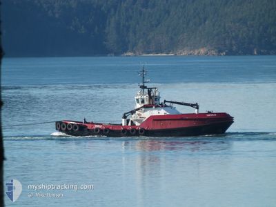
TANERLIQ
Tug
Current Trip
VARIOUS PORTS
| Time Travelled | 8 h, 51 mins |
|---|---|
| Remaining Time | --- |
| Distance Travelled | 23.97 nm |
| Remaining Distance | --- |
| AVG Speed | 8.8 Knots |
| MAX Speed | 10.5 Knots |
| AVG Wind | 2 knots |
| MAX Wind | 3 knots |
| MIN Temp | 14.8°C / 58.64°F |
| MAX Temp | 19.3°C / 66.74°F |
| Dybgang | 7 m |
| Position Modtaget | 2 m siden |
Current Position
| Longitude | -122.76722° |
|---|---|
| Latitude | 48.86885° |
| Status | At anchor |
| Fart | |
| Kurs | 308° |
| Område | The Coastal Waters of Southeast Alaska and British Columbia |
| Station | T-AIS |
| Position Modtaget | 2 m siden |
Info
Information
The current position of TANERLIQ is in The Coastal Waters of Southeast Alaska and British Columbia with coordinates 48.86885° / -122.76722° as reported on 2024-07-07 10:33 by AIS to our vessel tracker app. The vessel's current speed is 0 Knots
The vessel TANERLIQ (MMSI: 366760670) is a Tug It's sailing under the flag of [US] USA.
In this page you can find informations about the vessels current position, last detected port calls, and current voyage information. If the vessels is not in coverage by AIS you will find the latest position.
The current position of TANERLIQ is detected by our AIS receivers and we are not responsible for the reliability of the data. The last position was recorded while the vessel was in Coverage by the Ais receivers of our vessel tracking app.
The current draught of TANERLIQ as reported by AIS is 7 meters
Weather
| Temperature | 14.7°C / 58.46°F |
|---|---|
| Wind Speed | 2 knots |
| Direction | 179° S |
| Pressure | 1014.2 hPa |
| Humidity | 86.6 % |
| Cloud Coverage | --- |
Featured Company
Last Port Calls
| Port | Arrival | Departure | Time In Port |
|---|---|---|---|
| 2024-07-06 20:18 | 2024-07-07 01:45 | 5 h | |
| 2024-07-05 20:22 | 2024-07-06 20:06 | 23 h | |
| 2024-07-05 16:50 | 2024-07-05 17:16 | 26 m | |
| 2024-07-04 19:55 | 2024-07-05 13:43 | 17 h | |
| 2024-07-04 14:51 | 2024-07-04 15:19 | 28 m | |
| 2024-07-04 08:46 | 2024-07-04 09:57 | 1 h | |
| 2024-07-04 00:32 | 2024-07-04 01:13 | 41 m | |
| 2024-07-02 23:33 | 2024-07-03 00:19 | 46 m | |
| 2024-07-02 17:38 | 2024-07-02 18:24 | 46 m | |
| 2024-07-02 05:49 | 2024-07-02 06:22 | 33 m |
Most Visited Ports (Last year)
| Port | Arrivals | |
|---|---|---|
| 273 | ||
| 213 | ||
| 80 | ||
| 48 | ||
| 21 | ||
| 5 |
Last Trips
| Origin | Departure | Destination | Arrival | Distance | |
|---|---|---|---|---|---|
| 2024-07-06 13:06 | 2024-07-06 13:18 | 0.63 nm | |||
| 2024-07-05 10:16 | 2024-07-05 13:22 | 39.24 nm | |||
| 2024-07-05 06:43 | 2024-07-05 09:50 | 23.36 nm | |||
| 2024-07-04 08:19 | 2024-07-04 12:55 | 39.94 nm | |||
| 2024-07-04 02:57 | 2024-07-04 07:51 | 25.46 nm | |||
| 2024-07-03 18:13 | 2024-07-04 01:46 | 22.28 nm | |||
| 2024-07-02 17:19 | 2024-07-03 17:32 | 103.13 nm | |||
| 2024-07-02 11:24 | 2024-07-02 16:33 | 1.78 nm | |||
| 2024-07-01 23:22 | 2024-07-02 10:38 | 3.50 nm | |||
| 2024-06-30 17:47 | 2024-07-01 22:49 | 3.04 nm |
Events
| Tid | Hændelsen | Detaljer | Position / Dest | Info |
|---|---|---|---|---|
| 2024-07-07 10:19 | ETA er ændret | 2025/01/01 01:00 |
48.86885 / -122.76718
VARIOUS PORTS
|
Fart: Kurs: 305° |
| 2024-07-07 10:01 | ETA er ændret | 2025/01/01 01:00 |
48.86883 / -122.76722
VARIOUS PORTS
|
Fart: Kurs: 317° |
| 2024-07-07 09:43 | ETA er ændret | 2025/01/01 01:00 |
48.86886 / -122.76733
VARIOUS PORTS
|
Fart: Kurs: 320° |
| 2024-07-07 08:45 | Status er ændret | At anchor Default |
48.86878 / -122.76725
VARIOUS PORTS
|
Fart: Kurs: 325° |
| 2024-07-07 08:42 | Status er ændret | Default At anchor |
48.86877 / -122.76726
VARIOUS PORTS
|
Fart: Kurs: 328° |
| 2024-07-07 08:31 | ETA er ændret | 2025/01/01 01:00 |
48.86877 / -122.76728
VARIOUS PORTS
|
Fart: Kurs: 326° |
| 2024-07-07 07:37 | ETA er ændret | 2025/01/01 01:00 |
48.86878 / -122.76720
VARIOUS PORTS
|
Fart: Kurs: 319° |
| 2024-07-07 07:13 | ETA er ændret | 2025/01/01 01:00 |
48.86874 / -122.76728
VARIOUS PORTS
|
Fart: Kurs: 320° |
| 2024-07-07 06:57 | Status er ændret | At anchor Default |
48.86874 / -122.76730
VARIOUS PORTS
|
Fart: Kurs: 324° |
| 2024-07-07 06:54 | Status er ændret | Default At anchor |
48.86876 / -122.76726
VARIOUS PORTS
|
Fart: Kurs: 317° |