
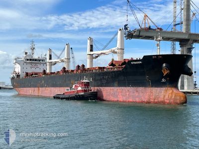
STRADION
Bulk Carrier
Current Trip
| Time Travelled | 2 days |
|---|---|
| Remaining Time | --- |
| Distance Travelled | 224.65 nm |
| Remaining Distance | --- |
| AVG Speed | 12.1 Knots |
| MAX Speed | 13.7 Knots |
| AVG Wind | 13.2 knots |
| MAX Wind | 23.8 knots |
| MIN Temp | -2.3°C / 27.86°F |
| MAX Temp | 4.2°C / 39.56°F |
| Dybgang | 10.1 m |
| Position Modtaget | 2025-11-21 17:14 |
Current Position
| Longitude | --- |
|---|---|
| Latitude | --- |
| Status | Under way using engine |
| Fart | 12 Knots |
| Kurs | 161.3° |
| Område | South China Sea |
| Station | T-AIS |
| Position Modtaget | 2025-11-21 17:14 |
Info
Information
The current position of STRADION is in South China Sea with coordinates 20.52607° / 107.30660° as reported on 2025-11-21 17:14 by AIS to our vessel tracker app. The vessel's current speed is 12 Knots and is heading at the port of HON GAI.
The vessel STRADION (IMO: 9522922, MMSI: 538008954) is a Bulk Carrier that was built in 2011 ( 15 år gamle ). It's sailing under the flag of [MH] Marshall Is.
In this page you can find informations about the vessels current position, last detected port calls, and current voyage information. If the vessels is not in coverage by AIS you will find the latest position.
The current position of STRADION is detected by our AIS receivers and we are not responsible for the reliability of the data. The last position was recorded while the vessel was in Coverage by the Ais receivers of our vessel tracking app.
The current draught of STRADION as reported by AIS is 10.1 meters
Weather
| Temperature | 2.8°C / 37.04°F |
|---|---|
| Wind Speed | 12 knots |
| Direction | 331° NNW |
| Pressure | 1030 hPa |
| Humidity | 37.4 % |
| Cloud Coverage | 83 % |
Featured Company
Events
| Tid | Hændelsen | Detaljer | Position / Dest | Info |
|---|---|---|---|---|
| 2026-01-06 04:05 | STOP Sejllads | 18.42 nm, South East of TIANJIN |
38.84404 / 118.09940
VN HON
|
Fart: 0.3 kn Kurs: 313° |
| 2026-01-05 09:36 | Afsejlet fra sidste havn |
|
40.29407 / 122.01953
VN HON
|
Fart: 12.6 kn Kurs: 277° |
| 2026-01-05 09:05 | START Sejllads |
40.25517 / 122.08881
[CN] BAYUQUAN
|
Fart: 5.1 kn Kurs: 11° |
|
| 2026-01-03 00:13 | STOP Sejllads |
40.25177 / 122.08215
[CN] BAYUQUAN
|
Fart: 0.3 kn Kurs: 179° |
|
| 2026-01-02 23:24 | Skibe i havn |
|
40.28995 / 122.06362
[CN] BAYUQUAN
|
Fart: 11.7 kn Kurs: 98° |
| 2026-01-02 21:25 | START Sejllads | 15.35 nm, West of BAYUQUAN |
40.22946 / 121.73324
VN HON
|
Fart: 6.4 kn Kurs: 107° |