
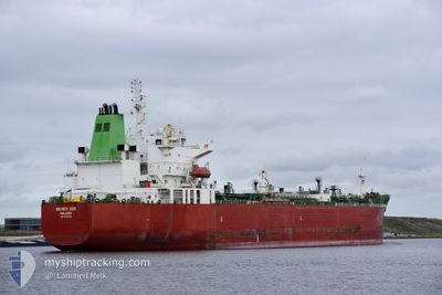
SILVER ZOE
Tanker
Current Trip
| Time Travelled | 1 day |
|---|---|
| Remaining Time | 1 day |
| Distance Travelled | 534.83 nm |
| Remaining Distance | 417.25 nm |
| AVG Speed | 12.6 Knots |
| MAX Speed | 13.5 Knots |
| AVG Wind | 6.5 knots |
| MAX Wind | 10 knots |
| MIN Temp | 20.4°C / 68.72°F |
| MAX Temp | 26.4°C / 79.52°F |
| Dybgang | 11.2 m |
| Position Modtaget | 21 d siden |
Current Position
| Longitude | --- |
|---|---|
| Latitude | --- |
| Status | Under way using engine |
| Fart | 10.6 Knots |
| Kurs | 165.9° |
| Område | Gulf of Mexico |
| Station | T-AIS |
| Position Modtaget | 21 d siden |
Info
Information
The current position of SILVER ZOE is in Gulf of Mexico with coordinates 29.12586° / -93.66470° as reported on 2024-11-05 20:16 by AIS to our vessel tracker app. The vessel's current speed is 10.6 Knots and is heading at the port of TUXPAN. The estimated time of arrival as calculated by MyShipTracking vessel tracking app is 2024-11-28 14:51 LT
The vessel SILVER ZOE (IMO: 9692325, MMSI: 538006366) is a Tanker It's sailing under the flag of [MH] Marshall Is.
In this page you can find informations about the vessels current position, last detected port calls, and current voyage information. If the vessels is not in coverage by AIS you will find the latest position.
The current position of SILVER ZOE is detected by our AIS receivers and we are not responsible for the reliability of the data. The last position was recorded while the vessel was in Coverage by the Ais receivers of our vessel tracking app.
The current draught of SILVER ZOE as reported by AIS is 11.2 meters
Weather
| Temperature | 22.6°C / 72.68°F |
|---|---|
| Wind Speed | 6 knots |
| Direction | 163° SSE |
| Pressure | 1018.6 hPa |
| Humidity | 77.3 % |
| Cloud Coverage | 71 % |
Featured Company
Last Port Calls
| Port | Arrival | Departure | Time In Port |
|---|---|---|---|
| 2024-11-24 00:39 | 2024-11-25 10:14 | 1 d | |
| 2024-11-03 05:38 | 2024-11-05 12:00 | 2 d | |
| 2024-10-26 16:55 | 2024-10-27 12:19 | 19 h | |
| 2024-10-14 14:05 | 2024-10-15 12:18 | 22 h | |
| 2024-10-11 23:32 | 2024-10-12 14:28 | 14 h | |
| 2024-10-05 16:36 | 2024-10-06 15:53 | 23 h | |
| 2024-10-04 22:35 | 2024-10-05 14:24 | 15 h |
Last Trips
| Origin | Departure | Destination | Arrival | Distance | |
|---|---|---|---|---|---|
| 2024-11-05 06:00 | 2024-11-23 18:39 | 944.96 nm | |||
| 2024-10-27 06:19 | 2024-11-03 00:38 | 746.08 nm | |||
| 2024-10-15 07:18 | 2024-10-26 11:55 | 630.61 nm | |||
| 2024-10-12 09:28 | 2024-10-14 09:05 | 11.19 nm | |||
| 2024-10-06 10:53 | 2024-10-11 18:32 | 173.48 nm | |||
| 2024-10-05 09:24 | 2024-10-05 11:36 | 13.83 nm | |||
| 2024-08-25 07:30 | 2024-10-04 17:35 | 4996.63 nm |
Events
| Tid | Hændelsen | Detaljer | Position / Dest | Info |
|---|---|---|---|---|
| 2024-11-25 10:14 | Afsejlet fra sidste havn |
|
18.17022 / -94.41534
TUXPAN
|
Fart: 11.3 kn Kurs: 342° |
| 2024-11-25 09:58 | START Sejllads |
18.13182 / -94.40473
[MX] COATZACOALCOS
|
Fart: 4.5 kn Kurs: 352° |
|
| 2024-11-24 00:39 | STOP Sejllads |
18.12388 / -94.40333
[MX] COATZACOALCOS
|
Fart: 0.1 kn Kurs: 180° |
|
| 2024-11-24 00:39 | Skibe i havn |
|
18.12388 / -94.40333
[MX] COATZACOALCOS
|
Fart: 0.8 kn Kurs: 176° |
| 2024-11-23 22:59 | START Sejllads | 6.62 nm, North East of COATZACOALCOS |
18.24925 / -94.36216
TUXPAN
|
Fart: 4.4 kn Kurs: 210° |