
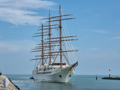
SEA CLOUD SPIRIT
Passenger
Current Trip
| Time Travelled | 3 days |
|---|---|
| Remaining Time | --- |
| Distance Travelled | 180.06 nm |
| Remaining Distance | --- |
| AVG Speed | 5.1 Knots |
| MAX Speed | 10.9 Knots |
| AVG Wind | 14.2 knots |
| MAX Wind | 17.7 knots |
| MIN Temp | 26.6°C / 79.88°F |
| MAX Temp | 27.5°C / 81.5°F |
| Dybgang | 5.9 m |
| Position Modtaget | 4 h, 8 m siden |
Current Position
| Longitude | --- |
|---|---|
| Latitude | --- |
| Status | Under way using engine |
| Fart | 10.6 Knots |
| Kurs | 116.9° |
| Område | Caribbean Sea |
| Station | T-AIS |
| Position Modtaget | 4 h, 8 m siden |
Info
Information
The current position of SEA CLOUD SPIRIT is in Caribbean Sea with coordinates 18.20215° / -64.41508° as reported on 2024-12-25 00:12 by AIS to our vessel tracker app. The vessel's current speed is 10.6 Knots
The vessel SEA CLOUD SPIRIT (IMO: 9483712, MMSI: 215855000) is a Passenger It's sailing under the flag of [MT] Malta.
In this page you can find informations about the vessels current position, last detected port calls, and current voyage information. If the vessels is not in coverage by AIS you will find the latest position.
The current position of SEA CLOUD SPIRIT is detected by our AIS receivers and we are not responsible for the reliability of the data. The last position was recorded while the vessel was in Coverage by the Ais receivers of our vessel tracking app.
The current draught of SEA CLOUD SPIRIT as reported by AIS is 5.9 meters
Weather
| Temperature | 27.2°C / 80.96°F |
|---|---|
| Wind Speed | 14 knots |
| Direction | 79° E |
| Pressure | 1015 hPa |
| Humidity | 72.9 % |
| Cloud Coverage | 14 % |
Featured Company
Last Port Calls
| Port | Arrival | Departure | Time In Port |
|---|---|---|---|
| 2024-12-21 06:34 | 2024-12-21 20:33 | 13 h | |
| 2024-12-16 07:12 | 2024-12-16 22:57 | 15 h | |
| 2024-12-11 06:19 | 2024-12-11 19:07 | 12 h | |
| 2024-12-06 08:27 | 2024-12-06 23:18 | 14 h | |
| 2024-12-04 06:08 | 2024-12-04 19:46 | 13 h | |
| 2024-11-27 05:58 | 2024-11-27 19:49 | 13 h | |
| 2024-11-11 05:45 | 2024-11-11 22:24 | 16 h | |
| 2024-11-10 06:32 | 2024-11-10 13:10 | 6 h | |
| 2024-11-08 07:36 | 2024-11-08 19:13 | 11 h | |
| 2024-11-06 07:46 | 2024-11-06 18:25 | 10 h |
Last Trips
| Origin | Departure | Destination | Arrival | Distance | |
|---|---|---|---|---|---|
| 2024-12-16 22:57 | 2024-12-21 06:34 | 447.34 nm | |||
| 2024-12-11 19:07 | 2024-12-16 07:12 | 458.43 nm | |||
| 2024-12-06 23:18 | 2024-12-11 06:19 | 308.29 nm | |||
| 2024-12-04 19:46 | 2024-12-06 08:27 | 195.22 nm | |||
| 2024-11-27 19:49 | 2024-12-04 06:08 | 678.09 nm | |||
| 2024-11-11 22:24 | 2024-11-27 05:58 | 3026.95 nm | |||
| 2024-11-10 13:10 | 2024-11-11 05:45 | 140.50 nm | |||
| 2024-11-08 19:13 | 2024-11-10 06:32 | 229.12 nm | |||
| 2024-11-06 18:25 | 2024-11-08 07:36 | 299.43 nm | |||
| 2024-11-04 22:58 | 2024-11-06 07:46 | 174.14 nm |
Events
| Tid | Hændelsen | Detaljer | Position / Dest | Info |
|---|---|---|---|---|
| 2024-12-25 00:25 | Status er ændret | Default Under way using engine |
18.18531 / -64.37981
VG VIJ
|
Fart: 10.6 kn Kurs: 116.9° |
| 2024-12-25 00:12 | Udenfor Dækning |
18.20215 / -64.41508
Caribbean Sea
|
Fart: 10.6 kn Kurs: 116.9° |
|
| 2024-12-25 00:08 | Status er ændret | Under way using engine Default |
18.20711 / -64.42509
VG VIJ
|
Fart: 10.7 kn Kurs: 115° |
| 2024-12-24 23:30 | Status er ændret | Default Under way using engine |
18.25843 / -64.53096
VG VIJ
|
Fart: 10 kn Kurs: 117° |
| 2024-12-24 23:06 | Status er ændret | Under way using engine Default |
18.29049 / -64.59882
VG VIJ
|
Fart: 10.9 kn Kurs: 120° |
| 2024-12-24 23:00 | Status er ændret | Default Under way using engine |
18.29821 / -64.61495
VG VIJ
|
Fart: 9 kn Kurs: 135° |
| 2024-12-24 22:48 | START Sejllads | 1.04 nm, West of NORMAN ISLAND |
18.32034 / -64.63343
VG VIJ
|
Fart: 7.8 kn Kurs: 203.8° |
| 2024-12-24 22:41 | Status er ændret | Under way using engine At anchor |
18.31995 / -64.62930
VG VIJ
|
Fart: 0.1 kn Kurs: 95° |
| 2024-12-24 22:09 | Status er ændret | At anchor Default |
18.31962 / -64.62849
VG VIJ
|
Fart: Kurs: 104° |
| 2024-12-24 21:48 | Status er ændret | Default At anchor |
18.31964 / -64.62849
VG VIJ
|
Fart: 0.1 kn Kurs: 100° |