
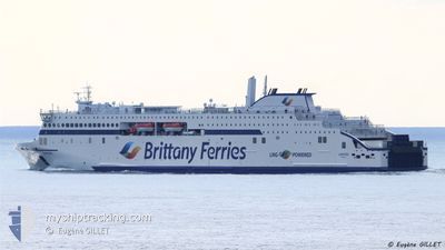
SANTONA
Passenger
Current Trip
| Time Travelled | 18 h, 31 mins |
|---|---|
| Remaining Time | 10 h, 45 mins |
| Distance Travelled | 328.99 nm |
| Remaining Distance | 190.64 nm |
| AVG Speed | 16.8 Knots |
| MAX Speed | 19.4 Knots |
| AVG Wind | 8.8 knots |
| MAX Wind | 25.8 knots |
| MIN Temp | 10°C / 50°F |
| MAX Temp | 14.4°C / 57.92°F |
| Dybgang | 6 m |
| Position Modtaget | 1 m siden |
Current Position
| Longitude | -4.50373° |
|---|---|
| Latitude | 48.80524° |
| Status | Under way using engine |
| Fart | 17.8 Knots |
| Kurs | 48.4° |
| Område | English Channel |
| Station | T-AIS |
| Position Modtaget | 1 m siden |
Info
Information
The current position of SANTONA is in English Channel with coordinates 48.80524° / -4.50373° as reported on 2024-05-06 06:43 by AIS to our vessel tracker app. The vessel's current speed is 17.8 Knots and is heading at the port of PORTSMOUTH. The estimated time of arrival as calculated by MyShipTracking vessel tracking app is 2024-05-06 17:29 LT
The vessel SANTONA (IMO: 9886847, MMSI: 228433900) is a Passenger It's sailing under the flag of [FR] France.
In this page you can find informations about the vessels current position, last detected port calls, and current voyage information. If the vessels is not in coverage by AIS you will find the latest position.
The current position of SANTONA is detected by our AIS receivers and we are not responsible for the reliability of the data. The last position was recorded while the vessel was in Coverage by the Ais receivers of our vessel tracking app.
The current draught of SANTONA as reported by AIS is 6 meters
Weather
| Temperature | 11.6°C / 52.88°F |
|---|---|
| Wind Speed | 11 knots |
| Direction | 30° NNE |
| Pressure | 1004.5 hPa |
| Humidity | 82 % |
| Cloud Coverage | 100 % |
Featured Company
Last Port Calls
| Port | Arrival | Departure | Time In Port |
|---|---|---|---|
| 2024-05-05 05:44 | 2024-05-05 12:13 | 6 h | |
| 2024-05-03 19:55 | 2024-05-03 23:01 | 3 h | |
| 2024-05-02 11:19 | 2024-05-02 17:11 | 5 h | |
| 2024-05-01 04:42 | 2024-05-01 08:23 | 3 h | |
| 2024-04-30 05:54 | 2024-04-30 10:58 | 5 h | |
| 2024-04-29 17:41 | 2024-04-29 21:18 | 3 h | |
| 2024-04-28 05:42 | 2024-04-28 12:17 | 6 h | |
| 2024-04-26 19:43 | 2024-04-26 23:00 | 3 h | |
| 2024-04-25 11:20 | 2024-04-25 17:25 | 6 h | |
| 2024-04-24 04:42 | 2024-04-24 08:12 | 3 h |
Last Trips
| Origin | Departure | Destination | Arrival | Distance | |
|---|---|---|---|---|---|
| 2024-05-04 00:01 | 2024-05-05 07:44 | 526.70 nm | |||
| 2024-05-02 19:11 | 2024-05-03 20:55 | 527.81 nm | |||
| 2024-05-01 09:23 | 2024-05-02 13:19 | 558.63 nm | |||
| 2024-04-30 12:58 | 2024-05-01 05:42 | 318.07 nm | |||
| 2024-04-29 22:18 | 2024-04-30 07:54 | 94.68 nm | |||
| 2024-04-28 14:17 | 2024-04-29 18:41 | 524.55 nm | |||
| 2024-04-27 00:00 | 2024-04-28 07:42 | 531.25 nm | |||
| 2024-04-25 19:25 | 2024-04-26 20:43 | 531.35 nm | |||
| 2024-04-24 09:12 | 2024-04-25 13:20 | 560.58 nm | |||
| 2024-04-23 12:42 | 2024-04-24 05:42 | 318.93 nm |
Events
| Tid | Hændelsen | Detaljer | Position / Dest | Info |
|---|---|---|---|---|
| 2024-05-06 06:20 | Ændre havområde | French part of the English Channel French part of the Celtic Sea |
48.72564 / -4.62729
English Channel
GB PME
|
Fart: 17.9 kn Kurs: 44.9° |
| 2024-05-06 02:53 | Ændre havområde | French part of the Celtic Sea Spanish part of the Bay of Biscay |
47.81654 / -4.68483
Celtic Sea
GB PME
|
Fart: 18.1 kn Kurs: 348.6° |
| 2024-05-06 02:52 | Status er ændret | Under way using engine Default |
47.81307 / -4.68403
GB PME
|
Fart: 18 kn Kurs: 353° |
| 2024-05-06 02:43 | Indenfor Dækning |
47.81654 / -4.68483
Celtic Sea
GB PME
|
Fart: 18.1 kn Kurs: 348.6° |
|
| 2024-05-05 12:42 | Status er ændret | Default Under way using engine |
43.57758 / -3.76762
GB PME
|
Fart: 18.8 kn Kurs: 354.7° |
| 2024-05-05 12:37 | Udenfor Dækning |
43.55181 / -3.76399
Bay of Biscay
GB PME
|
Fart: 18.8 kn Kurs: 354.7° |
|
| 2024-05-05 12:29 | Destination er ændret | GB PME ES SDR |
43.50568 / -3.75366
GB PME
|
Fart: 19.3 kn Kurs: 350.4° |
| 2024-05-05 12:29 | ETA er ændret | 2024/05/06 18:00 2024/05/05 06:00 |
43.50568 / -3.75366
GB PME
|
Fart: 19.3 kn Kurs: 350.4° |
| 2024-05-05 12:24 | Indenfor Dækning |
43.48844 / -3.74930
Bay of Biscay
|
Fart: 18.9 kn Kurs: 350° |
|
| 2024-05-05 12:13 | Afsejlet fra sidste havn |
|
43.48071 / -3.74743
ES SDR
|
Fart: Kurs: 203° |