
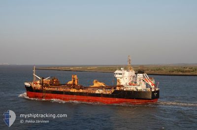
SAND FULMAR
Trailing Suction Hopper Dredger
Current Trip
GB CHN>===DREDGEA511
| Time Travelled | 5 days |
|---|---|
| Remaining Time | --- |
| Distance Travelled | 533.81 nm |
| Remaining Distance | --- |
| AVG Speed | 10.3 Knots |
| MAX Speed | 14.3 Knots |
| AVG Wind | 7.4 knots |
| MAX Wind | 22 knots |
| MIN Temp | 7.8°C / 46.04°F |
| MAX Temp | 15.4°C / 59.72°F |
| Dybgang | 4.5 m |
| Position Modtaget | 6 m siden |
Current Position
| Longitude | 0.02104° |
|---|---|
| Latitude | 51.49594° |
| Status | Moored |
| Fart | |
| Kurs | 109° |
| Område | North Sea |
| Station | T-AIS |
| Position Modtaget | 6 m siden |
Info
Information
The current position of SAND FULMAR is in North Sea with coordinates 51.49594° / 0.02104° as reported on 2024-05-05 23:20 by AIS to our vessel tracker app. The vessel's current speed is 0 Knots
The vessel SAND FULMAR (IMO: 9174127, MMSI: 232003580) is a Trailing Suction Hopper Dredger that was built in 1998 ( 26 år gamle ). It's sailing under the flag of [GB] United Kingdom.
In this page you can find informations about the vessels current position, last detected port calls, and current voyage information. If the vessels is not in coverage by AIS you will find the latest position.
The current position of SAND FULMAR is detected by our AIS receivers and we are not responsible for the reliability of the data. The last position was recorded while the vessel was in Coverage by the Ais receivers of our vessel tracking app.
The current draught of SAND FULMAR as reported by AIS is 4.5 meters
Weather
| Temperature | 10.2°C / 50.36°F |
|---|---|
| Wind Speed | 2 knots |
| Direction | 144° SE |
| Pressure | 1006.7 hPa |
| Humidity | 95.3 % |
| Cloud Coverage | 41 % |
Featured Company
Last Port Calls
| Port | Arrival | Departure | Time In Port |
|---|---|---|---|
| 2024-04-30 05:02 | 2024-04-30 12:37 | 7 h | |
| 2024-04-22 08:34 | 2024-04-25 14:08 | 3 d | |
| 2024-04-14 14:46 | 2024-04-17 08:10 | 2 d | |
| 2024-04-07 18:41 | 2024-04-10 12:34 | 2 d | |
| 2024-04-03 03:59 | 2024-04-03 17:30 | 13 h | |
| 2024-04-03 03:45 | 2024-04-03 03:49 | 3 m | |
| 2024-03-28 08:06 | 2024-03-29 08:32 | 1 d | |
| 2024-03-28 00:44 | 2024-03-28 07:24 | 6 h | |
| 2024-03-24 01:00 | 2024-03-24 20:35 | 19 h | |
| 2024-03-22 12:23 | 2024-03-22 20:10 | 7 h |
Last Trips
| Origin | Departure | Destination | Arrival | Distance | |
|---|---|---|---|---|---|
| 2024-04-25 15:08 | 2024-04-30 06:02 | 301.87 nm | |||
| 2024-04-17 10:10 | 2024-04-22 09:34 | 662.02 nm | |||
| 2024-04-10 13:34 | 2024-04-14 16:46 | 393.20 nm | |||
| 2024-04-03 18:30 | 2024-04-07 19:41 | 256.91 nm | |||
| 2024-04-03 04:49 | 2024-04-03 04:59 | 0.70 nm | |||
| 2024-03-29 08:32 | 2024-04-03 04:45 | 93.63 nm | |||
| 2024-03-28 07:24 | 2024-03-28 08:06 | 4.65 nm | |||
| 2024-03-24 20:35 | 2024-03-28 00:44 | 596.30 nm | |||
| 2024-03-22 20:10 | 2024-03-24 01:00 | 221.79 nm | |||
| 2024-03-20 19:35 | 2024-03-22 12:23 | 403.43 nm |
Events
| Tid | Hændelsen | Detaljer | Position / Dest | Info |
|---|---|---|---|---|
| 2024-05-05 22:47 | Dybgangen er ændret | 4.5 5 |
51.49593 / .02106
GB CHN>===DREDGEA511
|
Fart: Kurs: 109° |
| 2024-05-05 22:11 | Dybgangen er ændret | 5 7.2 |
51.49592 / .02105
GB CHN>===DREDGEA511
|
Fart: Kurs: 109° |
| 2024-05-05 21:30 | Destination er ændret | GB CHN>===DREDGEA511 ===DREDGEA507>GB CHN |
51.49593 / .02105
GB CHN>===DREDGEA511
|
Fart: Kurs: 109° |
| 2024-05-05 21:30 | ETA er ændret | 2024/05/06 15:30 2024/05/05 22:00 |
51.49593 / .02105
GB CHN>===DREDGEA511
|
Fart: Kurs: 109° |
| 2024-05-05 20:50 | Status er ændret | Moored Under way using engine |
51.49592 / .02111
===DREDGEA507>GB CHN
|
Fart: Kurs: 108° |
| 2024-05-05 20:47 | STOP Sejllads | 0.92 nm, West of SILVERTOWN |
51.49597 / .02105
===DREDGEA507>GB CHN
|
Fart: 0.3 kn Kurs: 114° |
| 2024-05-05 12:33 | START Sejllads | 15.53 nm, East of FELIXSTOWE |
51.95932 / 1.71801
===DREDGEA507>GB CHN
|
Fart: 3.2 kn Kurs: 248° |
| 2024-05-05 12:32 | Dybgangen er ændret | 7.2 6 |
51.95939 / 1.71924
===DREDGEA507>GB CHN
|
Fart: 2 kn Kurs: 241° |
| 2024-05-05 12:32 | Status er ændret | Under way using engine Restricted manoeuverability |
51.95940 / 1.71938
===DREDGEA507>GB CHN
|
Fart: 1.9 kn Kurs: 238° |
| 2024-05-05 12:01 | STOP Sejllads | 15.96 nm, East of FELIXSTOWE |
51.96639 / 1.72954
===DREDGEA507>GB CHN
|
Fart: 0.3 kn Kurs: 227° |