
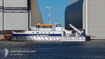
RV WIM WOLFF
Other Type
Current Trip
Current Position
| Longitude | 4.79401° |
|---|---|
| Latitude | 53.00613° |
| Status | Under way sailing |
| Fart | |
| Kurs | 112° |
| Område | North Sea |
| Station | T-AIS |
| Position Modtaget | Nu |
Info
Information
The current position of RV WIM WOLFF is in North Sea with coordinates 53.00613° / 4.79401° as reported on 2024-07-06 08:31 by AIS to our vessel tracker app. The vessel's current speed is 0 Knots and is currently inside the port of TEXEL.
The vessel RV WIM WOLFF (IMO: 9958559, MMSI: 246144000) is a Other Type It's sailing under the flag of [NL] Netherlands.
In this page you can find informations about the vessels current position, last detected port calls, and current voyage information. If the vessels is not in coverage by AIS you will find the latest position.
The current position of RV WIM WOLFF is detected by our AIS receivers and we are not responsible for the reliability of the data. The last position was recorded while the vessel was in Coverage by the Ais receivers of our vessel tracking app.
The current draught of RV WIM WOLFF as reported by AIS is 1.1 meters
Weather
| Temperature | 16.7°C / 62.06°F |
|---|---|
| Wind Speed | 24 knots |
| Direction | 216° SW |
| Pressure | 995.8 hPa |
| Humidity | 92.8 % |
| Cloud Coverage | 100 % |
Featured Company
Last Port Calls
| Port | Arrival | Departure | Time In Port |
|---|---|---|---|
| 2024-07-03 15:34 | |||
| 2024-06-28 18:07 | 2024-06-29 09:23 | 15 h | |
| 2024-06-21 12:13 | 2024-06-24 12:48 | 3 d | |
| 2024-06-11 14:58 | 2024-06-17 08:39 | 5 d | |
| 2024-05-28 15:49 | 2024-06-11 07:49 | 13 d | |
| 2024-05-13 15:05 | 2024-05-28 05:59 | 14 d | |
| 2024-05-13 08:12 |
Last Trips
| Origin | Departure | Destination | Arrival | Distance | |
|---|---|---|---|---|---|
| 2024-06-29 11:23 | 2024-07-03 17:34 | 84.95 nm | |||
| 2024-06-24 14:48 | 2024-06-28 20:07 | 47.52 nm | |||
| 2024-06-17 10:39 | 2024-06-21 14:13 | 74.02 nm | |||
| 2024-06-11 09:49 | 2024-06-11 16:58 | 49.36 nm | |||
| 2024-05-28 07:59 | 2024-05-28 17:49 | 75.29 nm | |||
| 2024-05-13 10:12 | 2024-05-13 17:05 | 48.24 nm |
Events
| Tid | Hændelsen | Detaljer | Position / Dest | Info |
|---|---|---|---|---|
| 2024-07-03 15:37 | STOP Sejllads |
53.00629 / 4.79406
[NL] TEXEL
|
Fart: 0.3 kn Kurs: 209° |
|
| 2024-07-03 15:34 | Skibe i havn |
|
53.00657 / 4.79876
[NL] TEXEL
|
Fart: 7 kn Kurs: 254° |
| 2024-07-03 09:50 | Status er ændret | Under way sailing At anchor |
53.31284 / 5.10762
TEXEL
|
Fart: 7.2 kn Kurs: 352.4° |
| 2024-07-03 09:40 | START Sejllads | 0.31 nm, East of VLIELAND |
53.29319 / 5.09032
TEXEL
|
Fart: 6.6 kn Kurs: 60.3° |
| 2024-07-03 06:04 | Status er ændret | At anchor Under way sailing |
53.29240 / 5.08817
TEXEL
|
Fart: 0.1 kn Kurs: 221° |
| 2024-07-03 06:00 | STOP Sejllads | 0.26 nm, South East of VLIELAND |
53.29219 / 5.08764
TEXEL
|
Fart: 0.3 kn Kurs: 226° |
| 2024-07-03 05:06 | START Sejllads | 2.7 nm, East of VLIELAND |
53.28501 / 5.15522
TEXEL
|
Fart: 3.4 kn Kurs: 118° |
| 2024-07-03 04:54 | Status er ændret | Under way sailing At anchor |
53.28486 / 5.15303
TEXEL
|
Fart: 0.1 kn Kurs: 241° |
| 2024-07-02 07:06 | Status er ændret | At anchor Under way sailing |
53.28447 / 5.15285
TEXEL
|
Fart: Kurs: 305° |
| 2024-07-02 06:40 | STOP Sejllads | 2.58 nm, East of VLIELAND |
53.28464 / 5.15170
TEXEL
|
Fart: 0.2 kn Kurs: 270° |