
RUN AWAY
Pleasure Craft
Current Trip
| Time Travelled | 3 days |
|---|---|
| Remaining Time | --- |
| Distance Travelled | 26.90 nm |
| Remaining Distance | --- |
| AVG Speed | 12.6 Knots |
| MAX Speed | 13.7 Knots |
| AVG Wind | 18.4 knots |
| MAX Wind | 19.4 knots |
| MIN Temp | 24.5°C / 76.1°F |
| MAX Temp | 27°C / 80.6°F |
| Dybgang | 2.3 m |
| Position Modtaget | 3 d siden |
Current Position
| Longitude | 27.34056° |
|---|---|
| Latitude | 36.95578° |
| Status | Under way using engine |
| Fart | 13.7 Knots |
| Kurs | 62° |
| Område | Aegean Sea |
| Station | T-AIS |
| Position Modtaget | 3 d siden |
Info
Information
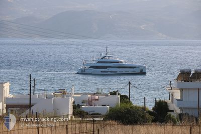
The current position of RUN AWAY is in Aegean Sea with coordinates 36.95578° / 27.34056° as reported on 2024-07-01 13:39 by AIS to our vessel tracker app. The vessel's current speed is 13.7 Knots
The vessel RUN AWAY (IMO: 9904375, MMSI: 319208800) is a Pleasure Craft It's sailing under the flag of [KY] Cayman Is.
In this page you can find informations about the vessels current position, last detected port calls, and current voyage information. If the vessels is not in coverage by AIS you will find the latest position.
The current position of RUN AWAY is detected by our AIS receivers and we are not responsible for the reliability of the data. The last position was recorded while the vessel was in Coverage by the Ais receivers of our vessel tracking app.
The current draught of RUN AWAY as reported by AIS is 2.3 meters
Weather
| Temperature | 27°C / 80.6°F |
|---|---|
| Wind Speed | 17 knots |
| Direction | 309° NW |
| Pressure | 1005.6 hPa |
| Humidity | 54.2 % |
| Cloud Coverage | --- |
Featured Company
Events
| Tid | Hændelsen | Detaljer | Position / Dest | Info |
|---|---|---|---|---|
| 2024-07-01 13:39 | Udenfor Dækning |
36.95578 / 27.34056
Aegean Sea
LEROS
|
Fart: 13.7 kn Kurs: 62° |
|
| 2024-07-01 13:10 | Fundet i havområde | Turkish part of the Aegean Sea |
36.96784 / 27.21787
Aegean Sea
LEROS
|
Fart: 12.8 kn Kurs: 119.1° |
| 2024-07-01 11:24 | Afsejlet fra sidste havn |
|
37.10798 / 26.82994
LEROS
|
Fart: 10.9 kn Kurs: 187° |
| 2024-07-01 11:23 | Indenfor Dækning |
37.10550 / 26.83160
Aegean Sea
LEROS
|
Fart: 11.8 kn Kurs: 154.5° |
|
| 2024-07-01 09:24 | Skibe i havn |
|
37.11216 / 26.83051
[GR] LEROS
|
Fart: 10.8 kn Kurs: 88.9° |
| 2024-07-01 09:22 | Udenfor Dækning |
37.10981 / 26.82112
Aegean Sea
LEROS
|
Fart: 10.8 kn Kurs: 88.9° |
|
| 2024-07-01 01:49 | Afsejlet fra sidste havn |
|
37.15087 / 25.25083
LEROS
|
Fart: 8.9 kn Kurs: 32° |
| 2024-07-01 01:46 | ETA er ændret | 2024/07/01 13:40 2024/07/01 13:00 |
37.14494 / 25.24529
[GR] NAOUSA
|
Fart: 7.9 kn Kurs: 29° |
| 2024-07-01 01:40 | Status er ændret | Under way using engine At anchor |
37.13807 / 25.23189
[GR] NAOUSA
|
Fart: 5.6 kn Kurs: 106° |
| 2024-07-01 01:38 | START Sejllads |
37.13947 / 25.22917
[GR] NAOUSA
|
Fart: 4.6 kn Kurs: 126° |