
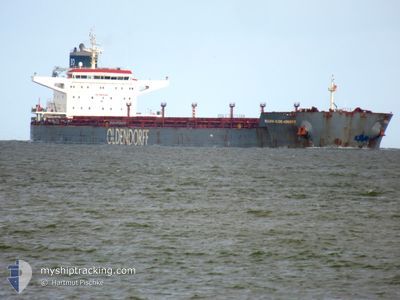
REGINA OLDENDORFF
Bulk Carrier
Current Trip
| Trip Time | 7 days |
|---|---|
| Trip Distance | 1500.50 nm |
| AVG Speed | 8.5 Knots |
| MAX Speed | 14.1 Knots |
| Dybgang | 7.4 m |
| AVG Wind | 17.3 knots |
| MAX Wind | 29.9 knots |
| MIN Temp | -8°C / 17.6°F |
| MAX Temp | 8.2°C / 46.76°F |
| Position Modtaget | 6 m siden |
Current Position
| Longitude | --- |
|---|---|
| Latitude | --- |
| Status | Moored |
| Fart | |
| Kurs | 278° |
| Område | Norwegian Sea |
| Station | T-AIS |
| Position Modtaget | 6 m siden |
Info
Information
The current position of REGINA OLDENDORFF is in Norwegian Sea with coordinates 68.42945° / 17.39066° as reported on 2024-12-02 12:01 by AIS to our vessel tracker app. The vessel's current speed is 0 Knots and is currently inside the port of NARVIK.
The vessel REGINA OLDENDORFF (IMO: 9535242, MMSI: 636092979) is a Bulk Carrier that was built in 2011 ( 13 år gamle ). It's sailing under the flag of [LR] Liberia.
In this page you can find informations about the vessels current position, last detected port calls, and current voyage information. If the vessels is not in coverage by AIS you will find the latest position.
The current position of REGINA OLDENDORFF is detected by our AIS receivers and we are not responsible for the reliability of the data. The last position was recorded while the vessel was in Coverage by the Ais receivers of our vessel tracking app.
The current draught of REGINA OLDENDORFF as reported by AIS is 7.4 meters
Weather
| Temperature | -3.6°C / 25.52°F |
|---|---|
| Wind Speed | 10 knots |
| Direction | 269° W |
| Pressure | 996.3 hPa |
| Humidity | 83.8 % |
| Cloud Coverage | 100 % |
Featured Company
Last Port Calls
| Port | Arrival | Departure | Time In Port |
|---|---|---|---|
| 2024-11-26 21:04 | |||
| 2024-11-14 21:15 | 2024-11-19 00:17 | 4 d | |
| 2024-10-19 20:49 | 2024-10-22 14:53 | 2 d |
Last Trips
| Origin | Departure | Destination | Arrival | Distance | |
|---|---|---|---|---|---|
| 2024-11-19 00:17 | 2024-11-26 21:04 | 1500.50 nm | |||
| 2024-10-22 14:53 | 2024-11-14 21:15 | 5571.95 nm | |||
| 2024-09-25 19:16 | 2024-10-19 20:49 | 3927.76 nm |
Events
| Tid | Hændelsen | Detaljer | Position / Dest | Info |
|---|---|---|---|---|
| 2024-12-01 01:40 | Status er ændret | Moored Under way using engine |
68.42941 / 17.39055
[NO] NARVIK
|
Fart: Kurs: 279° |
| 2024-12-01 00:57 | Status er ændret | Under way using engine At anchor |
68.42328 / 17.40964
[NO] NARVIK
|
Fart: 0.3 kn Kurs: 114° |
| 2024-12-01 00:03 | ETA er ændret | 2025/11/25 16:30 2024/11/25 16:30 |
68.42317 / 17.41075
[NO] NARVIK
|
Fart: Kurs: 114° |
| 2024-11-26 20:42 | Status er ændret | At anchor Under way using engine |
68.42518 / 17.41180
[NO] NARVIK
|
Fart: Kurs: 160° |
| 2024-11-26 20:18 | STOP Sejllads |
68.42387 / 17.41030
[NO] NARVIK
|
Fart: 0.3 kn Kurs: 130° |
|
| 2024-11-26 20:04 | Skibe i havn |
|
68.42677 / 17.38472
[NO] NARVIK
|
Fart: 4.2 kn Kurs: 128° |
| 2024-11-26 14:01 | ETA er ændret | 2024/11/25 16:30 2024/11/26 16:00 |
68.10453 / 15.09436
NONVK
|
Fart: 5.8 kn Kurs: 55.1° |
| 2024-11-26 11:13 | Dybgangen er ændret | 7.4 7.6 |
67.94499 / 14.50786
NONVK
|
Fart: 5.8 kn Kurs: 46.7° |
| 2024-11-25 00:59 | Status er ændret | Under way using engine Default |
66.86238 / 9.74057
NONVK
|
Fart: 8.2 kn Kurs: 180° |
| 2024-11-25 00:13 | Status er ændret | Default Under way using engine |
66.96764 / 9.72624
NONVK
|
Fart: 2.6 kn Kurs: 136° |