
RED RESOURCE
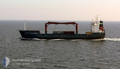
General Cargo
Current Trip
| Trip Time | 2 days |
|---|---|
| Trip Distance | 401.10 nm |
| AVG Speed | 9.5 Knots |
| MAX Speed | 11.2 Knots |
| Dybgang | 6.1 m |
| AVG Wind | 6.7 knots |
| MAX Wind | 15.8 knots |
| MIN Temp | 22.3°C / 72.14°F |
| MAX Temp | 28.7°C / 83.66°F |
| Position Modtaget | 6 d siden |
Current Position
| Longitude | 113.20340° |
|---|---|
| Latitude | -6.81440° |
| Status | Under way using engine |
| Fart | 9.7 Knots |
| Kurs | 92.2° |
| Område | Java Sea |
| Station | T-AIS |
| Position Modtaget | 6 d siden |
Info
Information
The current position of RED RESOURCE is in Java Sea with coordinates -6.81440° / 113.20340° as reported on 2024-06-30 18:30 by AIS to our vessel tracker app. The vessel's current speed is 9.7 Knots and is currently inside the port of MAUMERE.
The vessel RED RESOURCE (IMO: 9051583, MMSI: 525025099) is a General Cargo that was built in 1995 ( 29 år gamle ). It's sailing under the flag of [ID] Indonesia.
In this page you can find informations about the vessels current position, last detected port calls, and current voyage information. If the vessels is not in coverage by AIS you will find the latest position.
The current position of RED RESOURCE is detected by our AIS receivers and we are not responsible for the reliability of the data. The last position was recorded while the vessel was in Coverage by the Ais receivers of our vessel tracking app.
The current draught of RED RESOURCE as reported by AIS is 6.1 meters
Weather
| Temperature | 28.3°C / 82.94°F |
|---|---|
| Wind Speed | 6 knots |
| Direction | 207° SSW |
| Pressure | 1008.8 hPa |
| Humidity | 62 % |
| Cloud Coverage | 3 % |
Featured Company
Last Port Calls
| Port | Arrival | Departure | Time In Port |
|---|---|---|---|
| 2024-07-04 23:11 | |||
| 2024-07-02 04:05 | 2024-07-02 18:12 | 14 h | |
| 2024-06-27 22:40 | 2024-06-30 13:42 | 2 d | |
| 2024-06-20 07:06 | 2024-06-22 16:08 | 2 d | |
| 2024-06-18 02:20 | 2024-06-18 15:28 | 13 h | |
| 2024-06-14 16:55 | 2024-06-16 16:18 | 1 d | |
| 2024-06-07 23:49 | 2024-06-11 05:13 | 3 d | |
| 2024-06-05 09:58 | 2024-06-06 01:10 | 15 h | |
| 2024-05-31 17:21 | 2024-06-02 17:58 | 2 d | |
| 2024-05-27 20:36 | 2024-05-28 11:00 | 14 h |
Last Trips
| Origin | Departure | Destination | Arrival | Distance | |
|---|---|---|---|---|---|
| 2024-07-03 02:12 | 2024-07-05 07:11 | 401.10 nm | |||
| 2024-06-30 20:42 | 2024-07-02 12:05 | 329.28 nm | |||
| 2024-06-23 00:08 | 2024-06-28 05:40 | 624.41 nm | |||
| 2024-06-18 23:28 | 2024-06-20 15:06 | 371.22 nm | |||
| 2024-06-16 23:18 | 2024-06-18 10:20 | 326.45 nm | |||
| 2024-06-11 13:13 | 2024-06-14 23:55 | 623.08 nm | |||
| 2024-06-06 09:10 | 2024-06-08 07:49 | 365.21 nm | |||
| 2024-06-03 00:58 | 2024-06-05 17:58 | 337.13 nm | |||
| 2024-05-28 18:00 | 2024-06-01 00:21 | 54.38 nm | |||
| 2024-05-22 13:23 | 2024-05-28 03:36 | 778.53 nm |
Events
| Tid | Hændelsen | Detaljer | Position / Dest | Info |
|---|---|---|---|---|
| 2024-07-04 23:35 | STOP Sejllads |
-8.61549 / 122.22093
[ID] MAUMERE
|
Fart: 0.2 kn Kurs: -1° |
|
| 2024-07-04 23:11 | Skibe i havn |
|
-8.61705 / 122.22136
[ID] MAUMERE
|
Fart: 2 kn Kurs: -1° |
| 2024-07-04 20:58 | START Sejllads | 14.2 nm, North West of MAUMERE |
-8.44391 / 122.05302
ID.SWQ ___
|
Fart: 9.7 kn Kurs: 80° |
| 2024-07-04 09:12 | STOP Sejllads | 14.92 nm, North West of MAUMERE |
-8.44234 / 122.03776
ID.SWQ ___
|
Fart: 0.1 kn Kurs: -1° |
| 2024-07-02 18:12 | Afsejlet fra sidste havn |
|
-8.88636 / 116.73716
ID.SWQ ___
|
Fart: 5.7 kn Kurs: -1° |
| 2024-07-02 04:42 | STOP Sejllads |
-8.89755 / 116.74719
[ID] BENETE
|
Fart: Kurs: -1° |
|
| 2024-07-02 04:05 | Skibe i havn |
|
-8.89258 / 116.74503
[ID] BENETE
|
Fart: 5.5 kn Kurs: 119° |
| 2024-07-02 03:24 | START Sejllads | 2.64 nm, North of BENETE |
-8.84897 / 116.74274
ID.SWQ ___
|
Fart: 6.9 kn Kurs: 258° |
| 2024-07-01 23:33 | STOP Sejllads | 2.49 nm, North of BENETE |
-8.85126 / 116.74675
ID.SWQ ___
|
Fart: 0.3 kn Kurs: -1° |
| 2024-06-30 18:30 | Udenfor Dækning |
-6.81440 / 113.20340
Java Sea
ID.SWQ ___
|
Fart: 9.7 kn Kurs: 92.2° |