
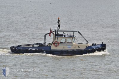
PROTECTOR
Tug
Current Trip
| Trip Time | 4 mins |
|---|---|
| Trip Distance | 0.30 nm |
| AVG Speed | --- |
| MAX Speed | --- |
| Dybgang | 2 m |
| AVG Wind | 11 knots |
| MAX Wind | 11 knots |
| MIN Temp | 11.5°C / 52.7°F |
| MAX Temp | 11.7°C / 53.06°F |
| Position Modtaget | 2 d siden |
Current Position
| Longitude | --- |
|---|---|
| Latitude | --- |
| Status | Under way using engine |
| Fart | |
| Kurs | --- |
| Område | North Sea |
| Station | T-AIS |
| Position Modtaget | 2 d siden |
Info
Information
The current position of PROTECTOR is in North Sea with coordinates 51.50150° / -0.12341° as reported on 2026-03-19 09:45 by AIS to our vessel tracker app. The vessel's current speed is 0 Knots and is currently inside the port of LONDON.
The vessel PROTECTOR (MMSI: 235040606) is a Tug It's sailing under the flag of [GB] United Kingdom.
In this page you can find informations about the vessels current position, last detected port calls, and current voyage information. If the vessels is not in coverage by AIS you will find the latest position.
The current position of PROTECTOR is detected by our AIS receivers and we are not responsible for the reliability of the data. The last position was recorded while the vessel was in Coverage by the Ais receivers of our vessel tracking app.
The current draught of PROTECTOR as reported by AIS is 2 meters
Weather
| Temperature | 10.9°C / 51.62°F |
|---|---|
| Wind Speed | 5 knots |
| Direction | 73° ENE |
| Pressure | 1027.4 hPa |
| Humidity | 63 % |
| Cloud Coverage | 2 % |
Featured Company
Last Port Calls
| Port | Arrival | Departure | Time In Port |
|---|---|---|---|
| 2026-03-11 13:23 | |||
| 2026-03-11 12:06 | 2026-03-11 13:19 | 1 h | |
| 2026-03-05 10:19 | 2026-03-11 11:46 | 6 d | |
| 2026-03-05 09:45 | 2026-03-05 10:15 | 30 m | |
| 2026-02-10 13:12 | 2026-03-05 09:00 | 22 d | |
| 2026-02-10 12:45 | 2026-02-10 12:57 | 12 m | |
| 2026-02-10 11:51 | 2026-02-10 12:03 | 12 m | |
| 2026-01-27 18:06 | 2026-02-10 10:32 | 13 d | |
| 2026-01-27 13:50 | 2026-01-27 14:16 | 25 m | |
| 2026-01-27 12:37 | 2026-01-27 13:08 | 31 m |
Last Trips
| Origin | Departure | Destination | Arrival | Distance | |
|---|---|---|---|---|---|
| 2026-03-11 13:19 | 2026-03-11 13:23 | 0.30 nm | |||
| 2026-03-11 11:46 | 2026-03-11 12:06 | 1.90 nm | |||
| 2026-03-05 10:15 | 2026-03-05 10:19 | 0.30 nm | |||
| 2026-03-05 09:00 | 2026-03-05 09:45 | 1.71 nm | |||
| 2026-02-10 12:57 | 2026-02-10 13:12 | 1.24 nm | |||
| 2026-02-10 12:03 | 2026-02-10 12:45 | 4.42 nm | |||
| 2026-02-10 10:32 | 2026-02-10 11:51 | 6.16 nm | |||
| 2026-01-27 14:16 | 2026-01-27 18:06 | 30.06 nm | |||
| 2026-01-27 13:08 | 2026-01-27 13:50 | 3.51 nm | |||
| 2026-01-27 10:26 | 2026-01-27 12:37 | 16.54 nm |
Events
| Tid | Hændelsen | Detaljer | Position / Dest | Info |
|---|---|---|---|---|
| 2026-03-19 09:45 | Udenfor Dækning |
51.50150 / -.12341
North Sea
[GB] LONDON
|
Fart: Kurs: 283.5° |
|
| 2026-03-19 07:45 | Indenfor Dækning |
51.50157 / -.12341
North Sea
[GB] LONDON
|
Fart: Kurs: 53.9° |
|
| 2026-03-18 15:45 | Status er ændret | Default Under way using engine |
51.50135 / -.12354
[GB] LONDON
|
Fart: 0.1 kn Kurs: 511° |
| 2026-03-18 15:42 | Udenfor Dækning |
51.50156 / -.12342
North Sea
[GB] LONDON
|
Fart: 0.1 kn Kurs: 132.8° |
|
| 2026-03-18 15:38 | STOP Sejllads |
51.50152 / -.12348
[GB] LONDON
|
Fart: 0.3 kn Kurs: 511° |
|
| 2026-03-18 15:21 | START Sejllads |
51.50987 / -.09969
[GB] LONDON
|
Fart: 3.8 kn Kurs: 287.4° |
|
| 2026-03-18 08:45 | STOP Sejllads |
51.50887 / -.09728
[GB] LONDON
|
Fart: 0.2 kn Kurs: 511° |
|
| 2026-03-18 08:28 | START Sejllads |
51.50326 / -.12194
[GB] LONDON
|
Fart: 4.7 kn Kurs: 16.5° |
|
| 2026-03-18 07:48 | Indenfor Dækning |
51.50151 / -.12339
North Sea
[GB] LONDON
|
Fart: Kurs: 322.7° |
|
| 2026-03-17 08:55 | Udenfor Dækning |
51.50157 / -.12338
North Sea
[GB] LONDON
|
Fart: Kurs: 296.7° |