
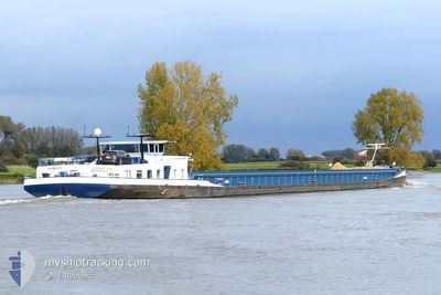
PORTERO
Cargo
Current Trip
ILE MONSIN
| Time Travelled | 1 day |
|---|---|
| Remaining Time | --- |
| Distance Travelled | 64.14 nm |
| Remaining Distance | --- |
| AVG Speed | 6.5 Knots |
| MAX Speed | 7.6 Knots |
| AVG Wind | 4.8 knots |
| MAX Wind | 6 knots |
| MIN Temp | 5.3°C / 41.54°F |
| MAX Temp | 11.4°C / 52.52°F |
| Dybgang | 3.7 m |
| Position Modtaget | 16 h, 35 m siden |
Current Position
| Longitude | --- |
|---|---|
| Latitude | --- |
| Status | Under way using engine |
| Fart | 7.7 Knots |
| Kurs | 174.9° |
| Område | North Sea |
| Station | T-AIS |
| Position Modtaget | 16 h, 35 m siden |
Info
Information
The current position of PORTERO is in North Sea with coordinates 50.79013° / 5.68862° as reported on 2025-12-12 04:41 by AIS to our vessel tracker app. The vessel's current speed is 7.7 Knots
The vessel PORTERO (MMSI: 244014269) is a Cargo It's sailing under the flag of [NL] Netherlands.
In this page you can find informations about the vessels current position, last detected port calls, and current voyage information. If the vessels is not in coverage by AIS you will find the latest position.
The current position of PORTERO is detected by our AIS receivers and we are not responsible for the reliability of the data. The last position was recorded while the vessel was in Coverage by the Ais receivers of our vessel tracking app.
The current draught of PORTERO as reported by AIS is 3.7 meters
Weather
| Temperature | 6.8°C / 44.24°F |
|---|---|
| Wind Speed | 5 knots |
| Direction | 183° S |
| Pressure | 1023.6 hPa |
| Humidity | 88.8 % |
| Cloud Coverage | 61 % |
Featured Company
Last Port Calls
| Port | Arrival | Departure | Time In Port |
|---|---|---|---|
| 2025-12-11 15:01 | 2025-12-11 17:59 | 2 h | |
| 2025-12-11 01:35 | 2025-12-11 06:32 | 4 h | |
| 2025-12-10 19:18 | 2025-12-11 01:06 | 5 h | |
| 2025-12-10 14:32 | 2025-12-10 14:56 | 24 m | |
| 2025-12-10 10:56 | 2025-12-10 11:56 | 59 m | |
| 2025-12-07 23:01 | 2025-12-10 07:05 | 2 d | |
| 2025-12-07 14:27 | 2025-12-07 15:09 | 41 m | |
| 2025-12-06 17:23 | 2025-12-06 17:36 | 13 m | |
| 2025-12-04 20:20 | 2025-12-04 21:55 | 1 h | |
| 2025-12-02 21:01 | 2025-12-02 22:58 | 1 h |
Last Trips
| Origin | Departure | Destination | Arrival | Distance | |
|---|---|---|---|---|---|
| 2025-12-11 06:32 | 2025-12-11 15:01 | 57.99 nm | |||
| 2025-12-11 01:06 | 2025-12-11 01:35 | 2.62 nm | |||
| 2025-12-10 14:56 | 2025-12-10 19:18 | 45.97 nm | |||
| 2025-12-10 11:56 | 2025-12-10 14:32 | 23.53 nm | |||
| 2025-12-10 07:05 | 2025-12-10 10:56 | 32.03 nm | |||
| 2025-12-07 15:09 | 2025-12-07 23:01 | 61.05 nm | |||
| 2025-12-06 17:36 | 2025-12-07 14:27 | 84.94 nm | |||
| 2025-12-04 21:55 | 2025-12-06 17:23 | 109.37 nm | |||
| 2025-12-02 22:58 | 2025-12-04 20:20 | 76.56 nm | |||
| 2025-12-02 17:18 | 2025-12-02 21:01 | 15.96 nm |
Events
| Tid | Hændelsen | Detaljer | Position / Dest | Info |
|---|---|---|---|---|
| 2025-12-12 06:47 | STOP Sejllads | 0.34 nm, West of WANDRE |
50.66000 / 5.63833
ILE MONSIN
|
Fart: Kurs: -1° |
| 2025-12-12 05:02 | Status er ændret | Default Under way using engine |
50.74500 / 5.67667
ILE MONSIN
|
Fart: 7.7 kn Kurs: 174.9° |
| 2025-12-12 04:41 | Udenfor Dækning |
50.79013 / 5.68862
North Sea
|
Fart: 7.7 kn Kurs: 174.9° |
|
| 2025-12-12 04:29 | Status er ændret | Under way using engine Default |
50.81011 / 5.67162
ILE MONSIN
|
Fart: 7 kn Kurs: 155° |
| 2025-12-12 04:29 | Indenfor Dækning |
50.81011 / 5.67162
North Sea
|
Fart: 7.2 kn Kurs: 128.8° |
|
| 2025-12-12 02:08 | START Sejllads | 2.03 nm, West of GENK |
50.93667 / 5.44667
ILE MONSIN
|
Fart: 7 kn Kurs: 100° |
| 2025-12-12 01:26 | STOP Sejllads | 2.85 nm, West of GENK |
50.93833 / 5.42500
ILE MONSIN
|
Fart: Kurs: -1° |
| 2025-12-11 22:32 | START Sejllads | 7.78 nm, South of DESSEL |
51.09667 / 5.11333
ILE MONSIN
|
Fart: 6 kn Kurs: 107° |
| 2025-12-11 22:20 | STOP Sejllads | 7.79 nm, South of DESSEL |
51.09667 / 5.10667
ILE MONSIN
|
Fart: Kurs: -1° |
| 2025-12-11 20:35 | START Sejllads | 0.05 nm, East of OLEN |
51.15500 / 4.87333
ILE MONSIN
|
Fart: 7 kn Kurs: 112° |