
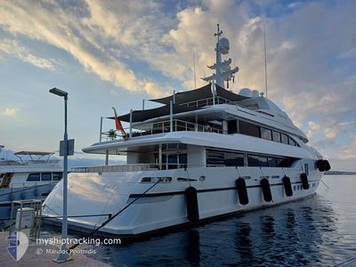
PERSEFONI I
Pleasure Craft
Current Trip
| Time Travelled | 1 day |
|---|---|
| Remaining Time | 1 day |
| Distance Travelled | 542.32 nm |
| Remaining Distance | 466.65 nm |
| AVG Speed | 13.8 Knots |
| MAX Speed | 17.1 Knots |
| AVG Wind | 4.6 knots |
| MAX Wind | 10 knots |
| MIN Temp | 16.6°C / 61.88°F |
| MAX Temp | 21.6°C / 70.88°F |
| Dybgang | 3 m |
| Position Modtaget | 2 m siden |
Current Position
| Longitude | 15.86635° |
|---|---|
| Latitude | 37.86798° |
| Status | Under way using engine |
| Fart | 13.5 Knots |
| Kurs | 93.7° |
| Område | Ionian Sea |
| Station | T-AIS |
| Position Modtaget | 2 m siden |
Info
Information
The current position of PERSEFONI I is in Ionian Sea with coordinates 37.86798° / 15.86635° as reported on 2024-05-29 04:05 by AIS to our vessel tracker app. The vessel's current speed is 13.5 Knots and is heading at the port of PIRAEUS. The estimated time of arrival as calculated by MyShipTracking vessel tracking app is 2024-05-30 18:12 LT
The vessel PERSEFONI I (IMO: 9636515, MMSI: 229702000) is a Pleasure Craft It's sailing under the flag of [MT] Malta.
In this page you can find informations about the vessels current position, last detected port calls, and current voyage information. If the vessels is not in coverage by AIS you will find the latest position.
The current position of PERSEFONI I is detected by our AIS receivers and we are not responsible for the reliability of the data. The last position was recorded while the vessel was in Coverage by the Ais receivers of our vessel tracking app.
The current draught of PERSEFONI I as reported by AIS is 3 meters
Weather
| Temperature | 20.3°C / 68.54°F |
|---|---|
| Wind Speed | 6 knots |
| Direction | 20° NNE |
| Pressure | 1012.9 hPa |
| Humidity | 65.9 % |
| Cloud Coverage | 19 % |
Featured Company
Last Port Calls
| Port | Arrival | Departure | Time In Port |
|---|---|---|---|
| 2024-05-17 17:37 | 2024-05-27 13:55 | 9 d | |
| 2024-05-14 15:12 |
Most Visited Ports (Last year)
| Port | Arrivals | |
|---|---|---|
| 9 | ||
| 4 | ||
| 4 | ||
| 3 | ||
| 3 | ||
| 3 |
Last Trips
| Origin | Departure | Destination | Arrival | Distance | |
|---|---|---|---|---|---|
| 2024-05-14 15:12 | 2024-05-17 17:37 | 930.60 nm |
Events
| Tid | Hændelsen | Detaljer | Position / Dest | Info |
|---|---|---|---|---|
| 2024-05-29 01:44 | Ændre havområde | Italian part of the Ionian Sea Italian part of the Tyrrhenian Sea |
38.25230 / 15.63511
Ionian Sea
ATHENS
|
Fart: 16.1 kn Kurs: 243.2° |
| 2024-05-29 00:03 | ETA er ændret | 2024/05/30 10:00 2024/05/30 16:00 |
38.54153 / 15.40771
ATHENS
|
Fart: 13.5 kn Kurs: 135.4° |
| 2024-05-28 23:19 | Indenfor Dækning |
38.65823 / 15.26111
Tyrrhenian Sea
ATHENS
|
Fart: 13.6 kn Kurs: 134.4° |
|
| 2024-05-28 16:47 | Udenfor Dækning |
39.64203 / 13.88171
Tyrrhenian Sea
ATHENS
|
Fart: 13.2 kn Kurs: 132° |
|
| 2024-05-28 16:45 | Indenfor Dækning |
39.64321 / 13.88000
Tyrrhenian Sea
ATHENS
|
Fart: 13.2 kn Kurs: 131° |
|
| 2024-05-28 10:21 | Udenfor Dækning |
40.62539 / 12.48052
Tyrrhenian Sea
ATHENS
|
Fart: 13.7 kn Kurs: 132.1° |
|
| 2024-05-28 10:21 | Indenfor Dækning |
40.62539 / 12.48052
Tyrrhenian Sea
ATHENS
|
Fart: 13.7 kn Kurs: 132.1° |
|
| 2024-05-28 00:18 | Udenfor Dækning |
42.14855 / 10.24559
Tyrrhenian Sea
ATHENS
|
Fart: 13.5 kn Kurs: 132.3° |
|
| 2024-05-27 21:51 | Ændre havområde | Italian part of the Tyrrhenian Sea French part of the Tyrrhenian Sea |
42.58154 / 9.81189
Tyrrhenian Sea
ATHENS
|
Fart: 13.6 kn Kurs: 153.3° |
| 2024-05-27 19:13 | Ændre havområde | French part of the Tyrrhenian Sea French part of the Ligurian Sea |
43.09914 / 9.47028
Tyrrhenian Sea
ATHENS
|
Fart: 13.6 kn Kurs: 155° |